Estimated Value: $473,000 - $512,000
3
Beds
3
Baths
2,316
Sq Ft
$215/Sq Ft
Est. Value
About This Home
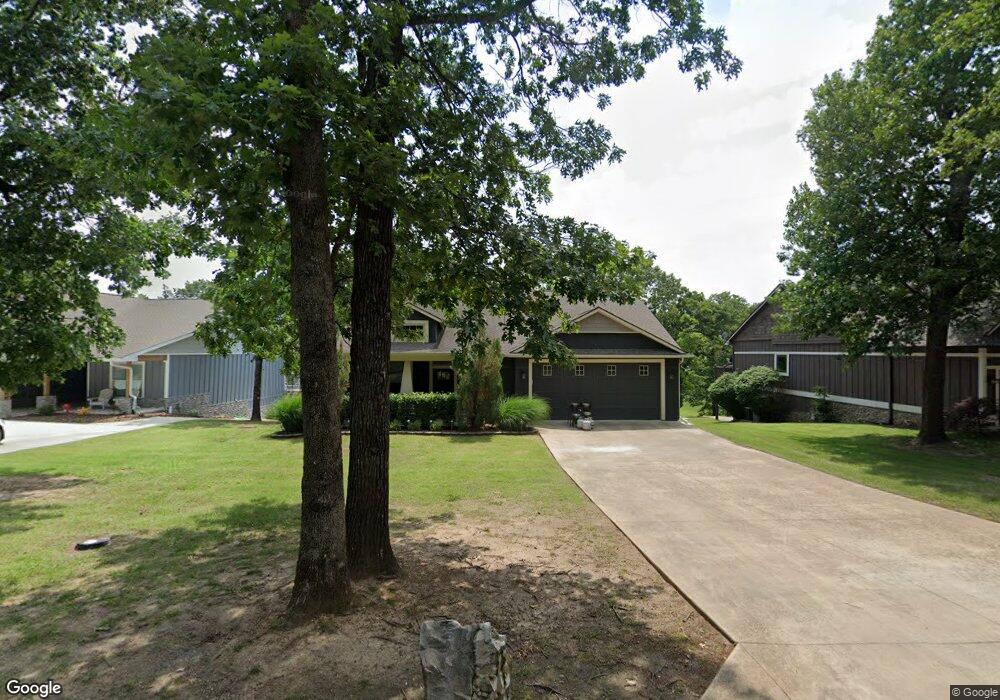
This home is located at 2096 Evans Dr, Grove, OK 74344 and is currently estimated at $499,016, approximately $215 per square foot. 2096 Evans Dr is a home located in Delaware County with nearby schools including Grove Lower Elementary School, Grove Upper Elementary School, and Grove Middle School.
Ownership History
Date
Name
Owned For
Owner Type
Purchase Details
Closed on
Jan 14, 2020
Sold by
Jones Steve
Bought by
Stafford Kenneth and Stafford Cynthia
Current Estimated Value
Home Financials for this Owner
Home Financials are based on the most recent Mortgage that was taken out on this home.
Original Mortgage
$265,374
Outstanding Balance
$233,965
Interest Rate
3.6%
Mortgage Type
FHA
Estimated Equity
$265,051
Purchase Details
Closed on
Dec 31, 2013
Sold by
Melody Point Llc
Bought by
Jones Steve
Create a Home Valuation Report for This Property
The Home Valuation Report is an in-depth analysis detailing your home's value as well as a comparison with similar homes in the area
Home Values in the Area
Average Home Value in this Area
Purchase History
| Date | Buyer | Sale Price | Title Company |
|---|---|---|---|
| Stafford Kenneth | $270,500 | Apex Title & Closing Svcs | |
| Jones Steve | $100,000 | -- |
Source: Public Records
Mortgage History
| Date | Status | Borrower | Loan Amount |
|---|---|---|---|
| Open | Stafford Kenneth | $265,374 |
Source: Public Records
Tax History
| Year | Tax Paid | Tax Assessment Tax Assessment Total Assessment is a certain percentage of the fair market value that is determined by local assessors to be the total taxable value of land and additions on the property. | Land | Improvement |
|---|---|---|---|---|
| 2025 | $2,774 | $34,267 | $4,614 | $29,653 |
| 2024 | $2,642 | $32,635 | $4,394 | $28,241 |
| 2023 | $2,642 | $31,082 | $4,313 | $26,769 |
| 2022 | $2,595 | $31,082 | $4,313 | $26,769 |
| 2021 | $2,589 | $31,082 | $4,313 | $26,769 |
| 2020 | $1,270 | $31,081 | $1,053 | $30,028 |
| 2019 | $1,214 | $14,273 | $1,053 | $13,220 |
| 2018 | $1,196 | $14,095 | $1,053 | $13,042 |
| 2017 | $1,231 | $14,802 | $1,053 | $13,749 |
| 2016 | $1,172 | $13,771 | $1,053 | $12,718 |
| 2015 | $66 | $765 | $765 | $0 |
| 2014 | $66 | $765 | $765 | $0 |
Source: Public Records
Map
Nearby Homes
- 2131 Dogwood Trail
- 2243 Lower Waterfall Rd
- 2668 Shasten St
- 2666 Shasten St
- 0 Upper Waterfall Dr
- 2373 Melody Point Cir
- 2850 Harber Oaks Loop
- 1019 Village Dr
- 1506 W 11th St
- 1709 Cardiac Cove Rd
- 1002 Poplar Ln
- 59488 E 301 Rd
- 1515 St Joseph Dr
- 1305 Dubois
- 59421 E 301 Rd
- 622 Alpine Dr
- 3126 Shore Dr
- 3112 Shore Dr
- 1616 Battle Dr
- 1663 Dilar Dr
- 2080 Evans Dr
- 2084 Evans Dr
- 2083 Evans Dr
- 2115 Mill Pond Cir
- 2113 Mill Pond Cir
- 2081 Evans Dr
- 2085 Evans Dr
- 2086 Evans Dr
- 2111 Mill Pond Cir
- 0 Mill Pond Cir
- 2087 Evans Dr
- 2123 Dogwood Trail
- 2092 Evans Dr
- 0 Evans Melody Point
- 1 & 2 Mill Pond Cir
- 3 & 4 Mill Pond Cir
- Lot 76 Evans Dr
- 0 Evans Dr
- 2079 Evans Dr
- 2505 Shasten St
Your Personal Tour Guide
Ask me questions while you tour the home.