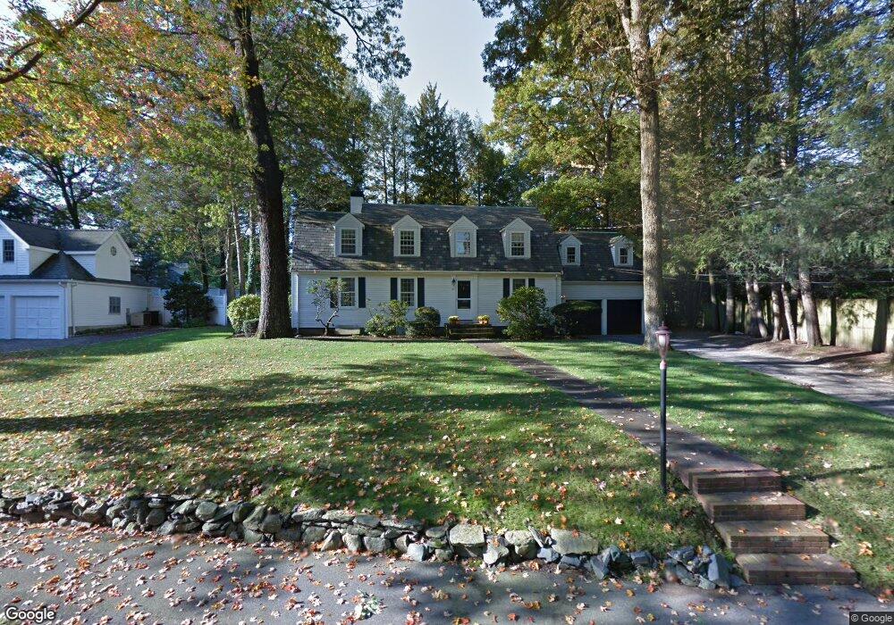
21 Barnstable Rd West Newton, MA 02465
West Newton NeighborhoodEstimated Value: $2,062,141 - $2,554,000
4
Beds
3
Baths
2,682
Sq Ft
$882/Sq Ft
Est. Value
About This Home
This home is located at 21 Barnstable Rd, West Newton, MA 02465 and is currently estimated at $2,365,785, approximately $882 per square foot. 21 Barnstable Rd is a home located in Middlesex County with nearby schools including Peirce Elementary School, F.A. Day Middle School, and Newton North High School.
Ownership History
Date
Name
Owned For
Owner Type
Purchase Details
Closed on
Jan 28, 2013
Sold by
Epstein Harvey and Esptein Debra S
Bought by
Epstein Rt and Epstein Harvey
Current Estimated Value
Home Financials for this Owner
Home Financials are based on the most recent Mortgage that was taken out on this home.
Original Mortgage
$248,000
Outstanding Balance
$172,354
Interest Rate
3.36%
Mortgage Type
New Conventional
Estimated Equity
$2,193,431
Purchase Details
Closed on
Jan 9, 2013
Sold by
Epstein Rt and Epstein Harvey
Bought by
Epstein Harvey and Epstein Debra S
Home Financials for this Owner
Home Financials are based on the most recent Mortgage that was taken out on this home.
Original Mortgage
$248,000
Outstanding Balance
$172,354
Interest Rate
3.36%
Mortgage Type
New Conventional
Estimated Equity
$2,193,431
Purchase Details
Closed on
May 19, 2008
Sold by
Luff-Epstein Debra
Bought by
Epstein Rt and Epstein Debra S
Purchase Details
Closed on
Sep 29, 1997
Sold by
Heller Robert F and Heller Sylvia C
Bought by
Epstein Harvey
Home Financials for this Owner
Home Financials are based on the most recent Mortgage that was taken out on this home.
Original Mortgage
$303,000
Interest Rate
7.47%
Purchase Details
Closed on
Aug 11, 1994
Sold by
Novich Neil S and Novich Deborah W
Bought by
Epstein Harvey and Luff-Epstein Debra
Purchase Details
Closed on
Oct 4, 1989
Sold by
Spencer Percy L
Bought by
Novich Neil S
Purchase Details
Closed on
Aug 15, 1988
Sold by
Moller Bernard
Bought by
Spencer Percy L
Create a Home Valuation Report for This Property
The Home Valuation Report is an in-depth analysis detailing your home's value as well as a comparison with similar homes in the area
Home Values in the Area
Average Home Value in this Area
Purchase History
| Date | Buyer | Sale Price | Title Company |
|---|---|---|---|
| Epstein Rt | -- | -- | |
| Epstein Harvey | -- | -- | |
| Epstein Rt | -- | -- | |
| Epstein Harvey | $13,000 | -- | |
| Epstein Harvey | $510,000 | -- | |
| Novich Neil S | $510,000 | -- | |
| Spencer Percy L | $524,000 | -- |
Source: Public Records
Mortgage History
| Date | Status | Borrower | Loan Amount |
|---|---|---|---|
| Open | Spencer Percy L | $248,000 | |
| Previous Owner | Spencer Percy L | $150,000 | |
| Previous Owner | Spencer Percy L | $303,000 |
Source: Public Records
Tax History Compared to Growth
Tax History
| Year | Tax Paid | Tax Assessment Tax Assessment Total Assessment is a certain percentage of the fair market value that is determined by local assessors to be the total taxable value of land and additions on the property. | Land | Improvement |
|---|---|---|---|---|
| 2025 | $18,561 | $1,894,000 | $1,310,300 | $583,700 |
| 2024 | $17,947 | $1,838,800 | $1,272,100 | $566,700 |
| 2023 | $17,161 | $1,685,800 | $992,700 | $693,100 |
| 2022 | $16,421 | $1,560,900 | $919,200 | $641,700 |
| 2021 | $15,844 | $1,472,500 | $867,200 | $605,300 |
| 2020 | $15,373 | $1,472,500 | $867,200 | $605,300 |
| 2019 | $11,580 | $1,429,600 | $841,900 | $587,700 |
| 2018 | $14,308 | $1,322,400 | $761,000 | $561,400 |
| 2017 | $13,872 | $1,247,500 | $717,900 | $529,600 |
| 2016 | $13,268 | $1,165,900 | $670,900 | $495,000 |
| 2015 | $12,650 | $1,089,600 | $627,000 | $462,600 |
Source: Public Records
Map
Nearby Homes
- 222 Prince St
- 39 Valentine Park
- 279 Chestnut St
- 308 Prince St
- 18 Sewall St
- 70 Bigelow Rd
- 1230 Commonwealth Ave
- 36 Troy Ln
- 46 Ellis Rd
- 10 Ruane Rd
- 443 Chestnut St
- 4 Hosmer Cir
- 479 Chestnut St
- 12 Inis Cir
- 79 Chestnut St Unit 2
- 68 Mignon Rd
- 318 Austin St Unit A
- 513 Chestnut St
- 154 Beaumont Ave
- 1488 Washington St Unit 1488
- 260 Chestnut St
- 27 Barnstable Rd
- 272 Chestnut St
- 22 Barnstable Rd
- 51 Barnstable Rd
- 8 Barnstable Rd
- 54 Hampshire St
- 38 Barnstable Rd
- 294 Chestnut St
- 288 Chestnut St
- 44 Barnstable Rd
- 271 Chestnut St
- 257 Chestnut St
- 56 Barnstable Rd
- 40 Hampshire St
- 51 Hampshire St
- 287 Chestnut St
- 64 Valentine Park
- 58 Valentine Park
- 54 Valentine Park