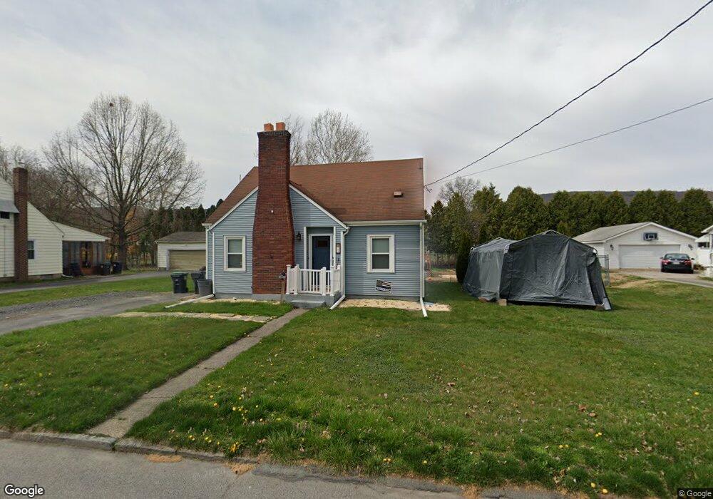
21 Bridge St Wyoming, PA 18644
Estimated Value: $181,000 - $230,302
3
Beds
2
Baths
1,470
Sq Ft
$136/Sq Ft
Est. Value
About This Home
This home is located at 21 Bridge St, Wyoming, PA 18644 and is currently estimated at $199,826, approximately $135 per square foot. 21 Bridge St is a home located in Luzerne County with nearby schools including Wyoming Area Secondary Center, Wyoming Area Catholic School, and Wyoming Seminary Lower School.
Ownership History
Date
Name
Owned For
Owner Type
Purchase Details
Closed on
Aug 25, 2018
Sold by
Labar Christine A
Bought by
Sims John H and Halecki Holly A
Current Estimated Value
Home Financials for this Owner
Home Financials are based on the most recent Mortgage that was taken out on this home.
Original Mortgage
$94,008
Outstanding Balance
$82,455
Interest Rate
4.87%
Mortgage Type
FHA
Estimated Equity
$117,371
Purchase Details
Closed on
Nov 3, 2017
Sold by
Loftus Thomas John and Estate Of Jeanine L Loftus
Bought by
Labar Christine A
Home Financials for this Owner
Home Financials are based on the most recent Mortgage that was taken out on this home.
Original Mortgage
$44,840
Interest Rate
3.83%
Mortgage Type
New Conventional
Purchase Details
Closed on
Jun 21, 1989
Bought by
Loftus Thomas and Loftus Jeanie
Create a Home Valuation Report for This Property
The Home Valuation Report is an in-depth analysis detailing your home's value as well as a comparison with similar homes in the area
Home Values in the Area
Average Home Value in this Area
Purchase History
| Date | Buyer | Sale Price | Title Company |
|---|---|---|---|
| Sims John H | $95,744 | None Available | |
| Labar Christine A | $46,235 | None Available | |
| Loftus Thomas | -- | -- |
Source: Public Records
Mortgage History
| Date | Status | Borrower | Loan Amount |
|---|---|---|---|
| Open | Sims John H | $94,008 | |
| Previous Owner | Labar Christine A | $44,840 |
Source: Public Records
Tax History Compared to Growth
Tax History
| Year | Tax Paid | Tax Assessment Tax Assessment Total Assessment is a certain percentage of the fair market value that is determined by local assessors to be the total taxable value of land and additions on the property. | Land | Improvement |
|---|---|---|---|---|
| 2025 | $2,674 | $89,400 | $34,700 | $54,700 |
| 2024 | $2,581 | $89,400 | $34,700 | $54,700 |
| 2023 | $2,393 | $89,400 | $34,700 | $54,700 |
| 2022 | $2,377 | $89,400 | $34,700 | $54,700 |
| 2021 | $2,255 | $89,400 | $34,700 | $54,700 |
| 2020 | $2,202 | $89,400 | $34,700 | $54,700 |
| 2019 | $2,139 | $89,400 | $34,700 | $54,700 |
| 2018 | $2,093 | $89,400 | $34,700 | $54,700 |
| 2017 | $2,046 | $89,400 | $34,700 | $54,700 |
| 2016 | -- | $89,400 | $34,700 | $54,700 |
| 2015 | $1,635 | $89,400 | $34,700 | $54,700 |
| 2014 | $1,635 | $89,400 | $34,700 | $54,700 |
Source: Public Records
Map
Nearby Homes
- 43 Hill St
- 271 Monument Ave
- 40-42 E 3rd St
- 282 Birchwood Ct
- 253 Birchwood Ct
- 547 Wyoming Ave
- 162 Birchwood Village Estates
- 36 Brown Crest Dr
- 5 Rowlands Ln
- 1946 Wyoming Ave Unit 134
- 1946 Wyoming Ave Unit 136
- 1946 Wyoming Ave Unit 193
- 1946 Wyoming Ave Unit 197
- 1946 Wyoming Ave Unit 148
- 1946 Wyoming Ave Unit 276
- 1946 Wyoming Ave Unit 131
- 1946 Wyoming Ave Unit 138
- 533 Dennison Ave
- 17 Mount Lookout Park
- 213 Cedar St