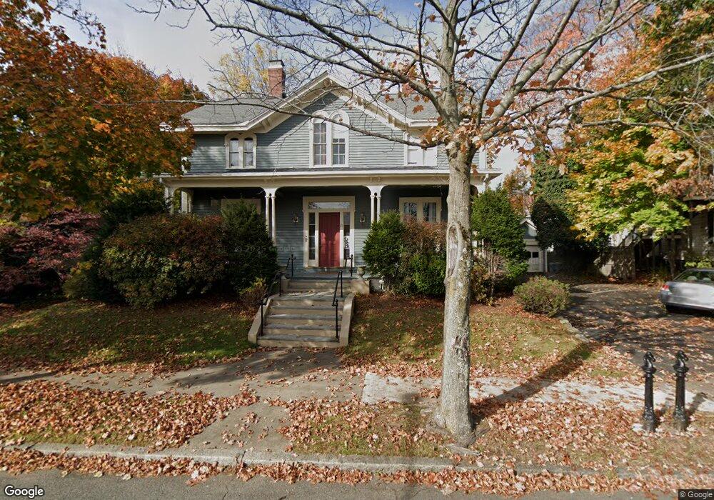
21 Chestnut St Wakefield, MA 01880
Downtown Wakefield NeighborhoodEstimated Value: $1,153,000 - $1,266,905
4
Beds
3
Baths
3,728
Sq Ft
$325/Sq Ft
Est. Value
About This Home
This home is located at 21 Chestnut St, Wakefield, MA 01880 and is currently estimated at $1,210,976, approximately $324 per square foot. 21 Chestnut St is a home located in Middlesex County with nearby schools including Wakefield Memorial High School, St Joseph School, and St. Patrick Elementary School.
Ownership History
Date
Name
Owned For
Owner Type
Purchase Details
Closed on
Nov 23, 2020
Sold by
21 Chestnut Street Rt
Bought by
John Gallo 2020 Ret
Current Estimated Value
Purchase Details
Closed on
Aug 6, 1999
Sold by
Lofton Nesbit C and Lofton Maryann
Bought by
21 Chestnut St Rt
Home Financials for this Owner
Home Financials are based on the most recent Mortgage that was taken out on this home.
Original Mortgage
$320,000
Interest Rate
7.54%
Mortgage Type
Purchase Money Mortgage
Purchase Details
Closed on
May 20, 1988
Sold by
Person Mark M
Bought by
Lofton Nesbit C
Create a Home Valuation Report for This Property
The Home Valuation Report is an in-depth analysis detailing your home's value as well as a comparison with similar homes in the area
Home Values in the Area
Average Home Value in this Area
Purchase History
| Date | Buyer | Sale Price | Title Company |
|---|---|---|---|
| John Gallo 2020 Ret | -- | None Available | |
| 21 Chestnut St Rt | $350,000 | -- | |
| Lofton Nesbit C | $288,000 | -- |
Source: Public Records
Mortgage History
| Date | Status | Borrower | Loan Amount |
|---|---|---|---|
| Previous Owner | Lofton Nesbit C | $400,000 | |
| Previous Owner | Lofton Nesbit C | $320,000 | |
| Previous Owner | Lofton Nesbit C | $35,000 | |
| Previous Owner | Lofton Nesbit C | $39,000 |
Source: Public Records
Tax History Compared to Growth
Tax History
| Year | Tax Paid | Tax Assessment Tax Assessment Total Assessment is a certain percentage of the fair market value that is determined by local assessors to be the total taxable value of land and additions on the property. | Land | Improvement |
|---|---|---|---|---|
| 2025 | $16,223 | $1,429,300 | $386,800 | $1,042,500 |
| 2024 | $15,986 | $1,421,000 | $384,500 | $1,036,500 |
| 2023 | $15,206 | $1,296,300 | $350,700 | $945,600 |
| 2022 | $14,550 | $1,181,000 | $319,400 | $861,600 |
| 2021 | $13,556 | $1,064,900 | $297,700 | $767,200 |
| 2020 | $12,713 | $995,500 | $278,300 | $717,200 |
| 2019 | $12,144 | $946,500 | $264,600 | $681,900 |
| 2018 | $11,311 | $873,400 | $244,100 | $629,300 |
| 2017 | $10,636 | $816,300 | $228,100 | $588,200 |
| 2016 | $9,960 | $738,300 | $215,800 | $522,500 |
| 2015 | $9,304 | $690,200 | $201,700 | $488,500 |
| 2014 | $8,482 | $663,700 | $193,900 | $469,800 |
Source: Public Records
Map
Nearby Homes
- 9 Avon St Unit 2
- 50 Albion St
- 6 Avon Ct Unit 2
- Unit 208 Plan at Wrenly
- Unit 310 Plan at Wrenly
- 47 Emerson St
- 62 Foundry St Unit 310
- 62 Foundry St Unit 312
- 62 Foundry St Unit 506
- 62 Foundry St Unit 202
- 62 Foundry St Unit 208
- 62 Foundry St Unit 414
- 62 Foundry St Unit 406
- 62 Foundry St Unit 313
- 51 Crescent St
- 34 Cedar St
- 69 Foundry St Unit 416
- 69 Foundry St Unit 310
- 24 Park St
- 16 Pleasant St
- 21 Chestnut St Unit 1
- 21 Chestnut St Unit 3
- 21 Chestnut St Unit 2
- 23 Chestnut St
- 19 Chestnut St Unit 2
- 19 Chestnut St Unit 1
- 19 Chestnut St
- 28 Avon St
- 30 Avon St
- 22 Chestnut St
- 26 Avon St Unit 2F
- 26 Avon St Unit 2
- 26 Avon St Unit 1
- 26 Avon St
- 32 Avon St
- 17 Chestnut St
- 17 Chestnut St Unit 1
- 24 Chestnut St
- 24 Chestnut St Unit 1
- 24 Chestnut St Unit 2