
Seller's Agent in 2026
Linda Filby
Compass Greater NY, LLC
(914) 772-5389
1 in this area
148 Total Sales
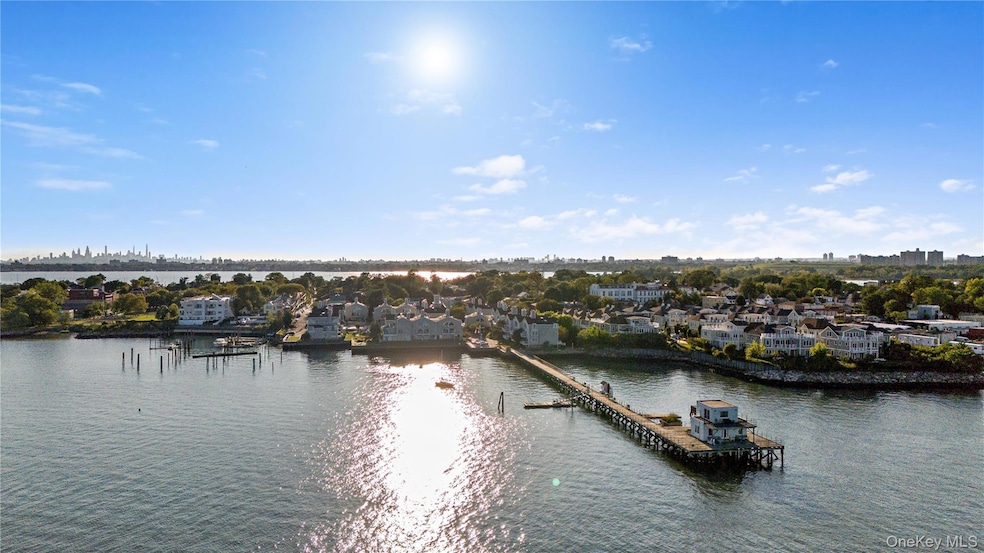
Yes, you can have it all! Discover the perfect blend of style, comfort, and security in this beautifully maintained tri-level residence located within City Island’s premier gated waterfront enclave. This turnkey 2-bedroom, 2.5-bath home offers modern upgrades, spacious living areas, and breathtaking water views—all designed for effortless, upscale living. The main level encompasses a light-filled living and entertaining space, step into a sun-drenched open-concept living and dining area featuring rich 1/2 inch engineered oak flooring and abundant natural light. The inviting living room boasts a cozy wood-burning fireplace and sliding glass doors that lead to your private balcony—ideal for relaxing with views of the in-ground pool and the sparkling Long Island Sound. The chef’s kitchen is a standout, equipped with top-of-the-line appliances including a Viking 6-burner gas range, Bosch dishwasher, French door refrigerator, granite countertops, and solid wood soft-close cabinetry. An oversized kitchen window brings in additional sunlight, while a stylish updated powder room adds convenience for guests. The second floor offers a spacious primary suite with spectacular water views, oversized windows, a Juliette balcony, generous closet space, and a fully renovated ensuite bathroom featuring a walk-in shower and elegant marble tile flooring. The second bedroom is equally bright and roomy, with two large closets and oversized windows. A beautifully updated hall bath with skylight serves the second bedroom, along with a separate laundry area featuring in-unit washer/dryer, linen closet, and utility closet for added convenience. Custom finishes throughout include crown molding, 3/4 inch solid oak floors and premium Graber window treatments. This home offers modern convenience with central air, forced heat and in -unit laundry, tandem garage parking space, which includes a 120V 20 amp outlet that has been permitted for a class 1 EV charger, and a storage shed. Beyond the residence, enjoy resort-style amenities: an outdoor in-ground pool, a pickleball court, a waterfront clubhouse for your private entertaining needs, dock and direct access to the Long Island Sound, a unit exclusive private mooring is fully transferable. With beach, golf and horse riding facilities near by relax and enjoy this wonderful gated community with 24-hour security and gatehouse attendant. Enjoy the tranquility of waterfront living without sacrificing access to the city. You're just minutes from schools, local shops, restaurants, and multiple transit options including, express bus service to Manhattan, city bus to the #6 subway line and easy access to major transportation links. Your waterfront lifestyle awaits at 21 Deepwater Way. Schedule your private showing today!
Last Agent to Sell the Property
Compass Greater NY, LLC Brokerage Phone: 914-341-1561 License #40ST0890979 Listed on: 09/13/2025
| Date | Type | Sale Price | Title Company |
|---|---|---|---|
| Deed | $680,000 | -- | |
| Deed | $447,500 | -- | |
| Bargain Sale Deed | $208,000 | Custom Title Services Inc |
| Date | Status | Loan Amount | Loan Type |
|---|---|---|---|
| Previous Owner | $225,125 | New Conventional | |
| Previous Owner | $166,400 | Purchase Money Mortgage |
| Date | Event | Price | List to Sale | Price per Sq Ft |
|---|---|---|---|---|
| 02/12/2026 02/12/26 | Sold | $680,000 | -2.9% | $436 / Sq Ft |
| 11/11/2025 11/11/25 | Pending | -- | -- | -- |
| 09/13/2025 09/13/25 | For Sale | $699,999 | -- | $449 / Sq Ft |
| Year | Tax Paid | Tax Assessment Tax Assessment Total Assessment is a certain percentage of the fair market value that is determined by local assessors to be the total taxable value of land and additions on the property. | Land | Improvement |
|---|---|---|---|---|
| 2025 | $8,002 | $41,189 | $5,647 | $35,542 |
| 2024 | $8,002 | $39,841 | $5,961 | $33,880 |
| 2023 | $7,679 | $37,810 | $5,740 | $32,070 |
| 2022 | $7,121 | $42,141 | $6,944 | $35,197 |
| 2021 | $0 | $38,755 | $6,944 | $31,811 |
| 2020 | $7,265 | $38,605 | $6,944 | $31,661 |
| 2019 | $6,945 | $33,201 | $6,944 | $26,257 |
| 2018 | $6,423 | $31,508 | $6,725 | $24,783 |
| 2017 | $5,760 | $29,725 | $6,944 | $22,781 |
| 2016 | $5,492 | $29,021 | $6,944 | $22,077 |
| 2015 | $3,323 | $28,603 | $6,944 | $21,659 |
| 2014 | $3,323 | $29,155 | $5,694 | $23,461 |
Seller's Agent in 2026
Linda Filby
Compass Greater NY, LLC
(914) 772-5389
1 in this area
148 Total Sales
D
Buyer's Agent in 2026
Denise Eaton
Coldwell Banker Realty
(561) 797-0380
1 in this area
2 Total Sales
Source: OneKey® MLS
MLS Number: 911308
APN: 05642-1039
Disclaimer: Certain information contained herein is derived from information provided by parties other than Homes.com. All information provided is deemed reliable, but is not guaranteed to be accurate and should be independently verified.
![]() The data relating to real estate for sale or lease on this web site comes in part from OneKey® MLS. Real estate listings held by brokerage firms other than Ten-X are marked with the OneKey® MLS logo or an abbreviated logo and detailed information about them includes the name of the listing broker.
The data relating to real estate for sale or lease on this web site comes in part from OneKey® MLS. Real estate listings held by brokerage firms other than Ten-X are marked with the OneKey® MLS logo or an abbreviated logo and detailed information about them includes the name of the listing broker.
Based on information submitted to the MLS GRID. All data is obtained from various sources and may not have been verified by broker or MLS GRID. Supplied Open House Information is subject to change without notice. All information should be independently reviewed and verified for accuracy. Properties may or may not be listed by the office/agent presenting the information. Some IDX listings have been excluded from this website. IDX information is provided exclusively for personal, non-commercial use, and may not be used for any purpose other than to identify prospective properties consumers may be interested in purchasing.
Information is deemed reliable but not guaranteed.
Copyright 2026 OneKey® MLS. All rights reserved.
Based on information submitted to the MLS GRID
Ask me questions while you tour the home.