


Listed by RE/MAX Lake and Country, Bought with RE/MAX Lake and Country
21 Eagle Rock Rd Tonasket, WA 98855
15
Acres
$7,333
Price per Acre
653,400
Sq Ft Lot
Highlights
- Lake View
- No HOA
- Level Lot
- 15 Acre Lot
- Open Space
About This Lot
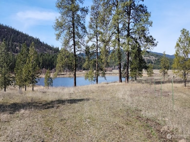
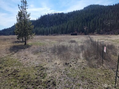
As of January 2025Deeded lakefeont access! Deeded Airstrip access! Discover the perfect canvas for your dreams on this pristine 15-acre parcel of level ground. With utilities already in place, including electricity, septic, and a dug well this property is ready for development or your custom-built oasis! Enjoy deeded access to the neighboring lake, offering endless opportunities for water recreation and relaxation. The property boasts breathtaking mountain views, providing a picturesque backdrop for your new home or retreat. Located just off the paved road, this property offers convenience and accessibility while still maintaining a peaceful and secluded atmosphere.
Source: Northwest Multiple Listing Service (NWMLS)
MLS#: 2209768
Property Details
Property Type
- Land
Est. Annual Taxes
- $289
Lot Details
- 15 Acre Lot
- Open Space
- Level Lot
Property Views
- Lake
- Mountain
- Territorial
- Limited
Schools
- Tonasket Elementary School
- Tonasket Mid Middle School
- Tonasket High School
Utilities
- Well
- Septic Design Installed
- Sewer Not Available
Community Details
- No Home Owners Association
- Aeneas Valley Subdivision
Listing and Financial Details
- Assessor Parcel Number 3630340012
Ownership History
Date
Name
Owned For
Owner Type
Purchase Details
Listed on
Mar 16, 2024
Closed on
Jan 13, 2025
Sold by
Bernhardt Ronald L and Macadandang Melony
Bought by
Monahan Mary C and Monahan Timothy
Seller's Agent
Shane DeVon
RE/MAX Lake and Country
Buyer's Agent
Rocky DeVon
RE/MAX Lake and Country
List Price
$120,000
Sold Price
$110,000
Premium/Discount to List
-$10,000
-8.33%
Total Days on Market
249
Views
59
Current Estimated Value
Home Financials for this Owner
Home Financials are based on the most recent Mortgage that was taken out on this home.
Estimated Appreciation
-$11,500
Avg. Annual Appreciation
-26.42%
Purchase Details
Closed on
Sep 6, 2024
Sold by
Zumwalt Mack D
Bought by
Bernhardt Ronald L
Map
Create a Home Valuation Report for This Property
The Home Valuation Report is an in-depth analysis detailing your home's value as well as a comparison with similar homes in the area
Similar Property in Tonasket, WA
Home Values in the Area
Average Home Value in this Area
Purchase History
| Date | Type | Sale Price | Title Company |
|---|---|---|---|
| Warranty Deed | $92,813 | Cw Title And Escrow | |
| Quit Claim Deed | -- | Cw Title And Escrow |
Source: Public Records
Property History
| Date | Event | Price | Change | Sq Ft Price |
|---|---|---|---|---|
| 01/15/2025 01/15/25 | Sold | $110,000 | 0.0% | -- |
| 11/20/2024 11/20/24 | Pending | -- | -- | -- |
| 06/23/2024 06/23/24 | Price Changed | $110,000 | -8.3% | -- |
| 03/16/2024 03/16/24 | For Sale | $120,000 | -- | -- |
Source: Northwest Multiple Listing Service (NWMLS)
Tax History
| Year | Tax Paid | Tax Assessment Tax Assessment Total Assessment is a certain percentage of the fair market value that is determined by local assessors to be the total taxable value of land and additions on the property. | Land | Improvement |
|---|---|---|---|---|
| 2025 | $289 | $26,500 | $22,500 | $4,000 |
| 2024 | $289 | $26,500 | $22,500 | $4,000 |
| 2022 | $345 | $26,500 | $22,500 | $4,000 |
| 2021 | $351 | $26,500 | $22,500 | $4,000 |
| 2020 | $358 | $26,500 | $22,500 | $4,000 |
| 2019 | $342 | $26,500 | $22,500 | $4,000 |
| 2018 | $365 | $26,500 | $22,500 | $4,000 |
| 2017 | $333 | $26,500 | $22,500 | $4,000 |
| 2016 | $331 | $26,500 | $22,500 | $4,000 |
| 2015 | $331 | $26,500 | $22,500 | $4,000 |
| 2013 | -- | $26,500 | $22,500 | $4,000 |
Source: Public Records
Source: Northwest Multiple Listing Service (NWMLS)
MLS Number: 2209768
APN: 3630340012
Disclaimer: Certain information contained herein is derived from information provided by parties other than Homes.com. All information provided is deemed reliable, but is not guaranteed to be accurate and should be independently verified.
![]() Listing information is provided by the Northwest Multiple Listing Service (NWMLS). Property information is based on available data that may include MLS information, county records, and other sources. Listings marked with the 3 tree icon and provided by NWMLS. All properties are subject to prior sale or withdrawal. ©2025 NWMLS.
Listing information is provided by the Northwest Multiple Listing Service (NWMLS). Property information is based on available data that may include MLS information, county records, and other sources. Listings marked with the 3 tree icon and provided by NWMLS. All properties are subject to prior sale or withdrawal. ©2025 NWMLS.
Nearby Homes
- 1041 Aeneas Valley Rd
- 0 TBD Eaglestone Rd
- TBD Eaglestone Rd
- 1721 & 1813 Aeneas Valley Rd
- 8 Fawn Ln
- 19 Lot Doe Ln
- 103 Stonehaven Rd
- 193 Blue Meadow Rd
- 447 Roundabout Rd
- 117 Squirrel Rd
- 722 Aeneas Valley Rd
- 0 Cape Labelle Neil Cir Unit NWM2372458
- 1111 TBD White Tail Ln
- 0 Xxx Cabin View Dr Unit 17794260
- 0 Xxx Cabin View Dr Unit 11195087
- 0 XX Cabin View Dr
- 0 Lot 315 Lost Creek Way
- 0 Lot 316 Lost Creek Way
- 337 Lot Watoka Way
- 111 Watoka Way