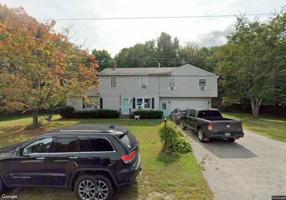
21 Eleanor Ave Westbrook, ME 04092
Estimated Value: $575,071 - $686,000
6
Beds
4
Baths
2,378
Sq Ft
$266/Sq Ft
Est. Value
About This Home
This home is located at 21 Eleanor Ave, Westbrook, ME 04092 and is currently estimated at $632,018, approximately $265 per square foot. 21 Eleanor Ave is a home located in Cumberland County with nearby schools including Westbrook High School and The Little Dolphin School Foundation.
Ownership History
Date
Name
Owned For
Owner Type
Purchase Details
Closed on
Nov 26, 2018
Sold by
Flynn David E and Flynn Linda M
Bought by
Troiano Amy and Troiano Robert J
Current Estimated Value
Home Financials for this Owner
Home Financials are based on the most recent Mortgage that was taken out on this home.
Original Mortgage
$248,000
Outstanding Balance
$218,083
Interest Rate
4.9%
Mortgage Type
New Conventional
Estimated Equity
$413,935
Create a Home Valuation Report for This Property
The Home Valuation Report is an in-depth analysis detailing your home's value as well as a comparison with similar homes in the area
Home Values in the Area
Average Home Value in this Area
Purchase History
| Date | Buyer | Sale Price | Title Company |
|---|---|---|---|
| Troiano Amy | -- | -- |
Source: Public Records
Mortgage History
| Date | Status | Borrower | Loan Amount |
|---|---|---|---|
| Open | Troiano Amy | $248,000 |
Source: Public Records
Tax History
| Year | Tax Paid | Tax Assessment Tax Assessment Total Assessment is a certain percentage of the fair market value that is determined by local assessors to be the total taxable value of land and additions on the property. | Land | Improvement |
|---|---|---|---|---|
| 2023 | $5,806 | $348,100 | $89,200 | $258,900 |
| 2022 | $5,285 | $292,000 | $74,400 | $217,600 |
| 2021 | $5,206 | $292,000 | $74,400 | $217,600 |
| 2020 | $5,215 | $292,000 | $74,400 | $217,600 |
| 2019 | $5,215 | $292,000 | $74,400 | $217,600 |
| 2018 | $4,450 | $249,200 | $64,800 | $184,400 |
| 2017 | $4,705 | $249,200 | $64,800 | $184,400 |
| 2016 | $4,585 | $249,200 | $64,800 | $184,400 |
| 2015 | $4,476 | $249,200 | $64,800 | $184,400 |
| 2014 | $4,286 | $249,200 | $64,800 | $184,400 |
| 2013 | $4,286 | $249,200 | $64,800 | $184,400 |
Source: Public Records
Map
Nearby Homes
- 162 Wickham Way
- 171 Wickham Way
- 213 Wickham Way
- 204 Wickham Way Unit Lot 204
- 79 Buckingham Dr
- 13 Windsor Dr
- 121 Victoria Dr
- 547 Saco St
- 76 County Rd
- 11 Dragonfly Ln
- 30 Fairway Commons Dr Unit 10
- 20 Fairway Commons Dr Unit 2
- 25 Fairway Commons Dr Unit 7
- Unit 13 Fairway Commons Dr Unit 13
- 31 Fairway Commons Dr Unit 12
- 280 Longfellow St Unit 17
- 184 Central St
- 218 Longfellow St
- 16 Thistle Dr Unit C
- 25 Longfellow Dr
- 18 Eleanor Ave
- 11 Eleanor Ave
- 24 Eleanor Ave
- 700 Saco St Unit 7
- 700 Saco St Unit 6
- 700 Saco St Unit 5
- 700 Saco St Unit 3
- 700 Saco St Unit 2
- 700 Saco St Unit 1
- 700A Saco St
- 700 Saco St
- 732 Saco St
- 862 Saco St
- 110 Saco St
- 665 Saco St
- 665 Saco St Unit 53
- 665 Saco St Unit 75
- 665 Saco St Unit 105
- 665 Saco St
- 665 Saco St
Your Personal Tour Guide
Ask me questions while you tour the home.