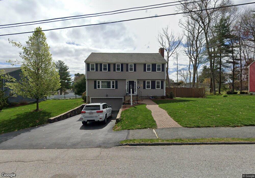
21 Emily Rd Framingham, MA 01701
Estimated Value: $743,444 - $892,000
4
Beds
3
Baths
2,340
Sq Ft
$345/Sq Ft
Est. Value
About This Home
This home is located at 21 Emily Rd, Framingham, MA 01701 and is currently estimated at $806,611, approximately $344 per square foot. 21 Emily Rd is a home located in Middlesex County with nearby schools including Framingham High School, Christa McAuliffe Charter School, and Happy Hollow School.
Ownership History
Date
Name
Owned For
Owner Type
Purchase Details
Closed on
Jul 24, 2025
Sold by
Tashian Mark and Tashian Kelly J
Bought by
21 Emily Road Rt and Tashian
Current Estimated Value
Purchase Details
Closed on
Nov 29, 2004
Sold by
Fowks Gregory W and Fowks Stacy H
Bought by
Tashian Kelly J and Tashian Mark A
Home Financials for this Owner
Home Financials are based on the most recent Mortgage that was taken out on this home.
Original Mortgage
$315,000
Interest Rate
5.75%
Mortgage Type
Purchase Money Mortgage
Purchase Details
Closed on
Aug 15, 1997
Sold by
Thornton Nancy
Bought by
Fowks Gregory and Fowks Stacy H
Purchase Details
Closed on
Oct 29, 1993
Sold by
Prenovitz Roberta
Bought by
Thornton Nancy
Create a Home Valuation Report for This Property
The Home Valuation Report is an in-depth analysis detailing your home's value as well as a comparison with similar homes in the area
Home Values in the Area
Average Home Value in this Area
Purchase History
| Date | Buyer | Sale Price | Title Company |
|---|---|---|---|
| 21 Emily Road Rt | -- | -- | |
| Tashian Kelly J | $450,000 | -- | |
| Tashian Kelly | $450,000 | -- | |
| Fowks Gregory | $235,000 | -- | |
| Fowks Gregory W | $235,000 | -- | |
| Thornton Nancy | $220,000 | -- | |
| Thornton Nancy A | $220,000 | -- |
Source: Public Records
Mortgage History
| Date | Status | Borrower | Loan Amount |
|---|---|---|---|
| Previous Owner | Thornton Nancy A | $295,000 | |
| Previous Owner | Tashian Kelly | $315,000 |
Source: Public Records
Tax History
| Year | Tax Paid | Tax Assessment Tax Assessment Total Assessment is a certain percentage of the fair market value that is determined by local assessors to be the total taxable value of land and additions on the property. | Land | Improvement |
|---|---|---|---|---|
| 2025 | $7,742 | $648,400 | $260,300 | $388,100 |
| 2024 | $7,645 | $613,600 | $232,400 | $381,200 |
| 2023 | $7,220 | $551,600 | $207,400 | $344,200 |
| 2022 | $6,862 | $499,400 | $188,200 | $311,200 |
| 2021 | $6,677 | $475,200 | $180,900 | $294,300 |
| 2020 | $6,450 | $430,600 | $164,400 | $266,200 |
| 2019 | $6,337 | $412,000 | $164,400 | $247,600 |
| 2018 | $6,208 | $380,400 | $158,300 | $222,100 |
| 2017 | $5,924 | $354,500 | $153,600 | $200,900 |
| 2016 | $5,894 | $339,100 | $153,600 | $185,500 |
| 2015 | $6,045 | $339,200 | $154,000 | $185,200 |
Source: Public Records
Map
Nearby Homes
- 8 Emily Rd
- 447 Old Connecticut Path
- 7 Ballydrain Rd
- 35 Gleason St
- 108 Cherry St
- Lot 3 Murray Hill Rd
- 689 Old Connecticut Path
- 14 Ridgefield Dr
- 30 A St
- 13 Hamilton St
- 109 Hastings St
- 11 Danforth Park Rd
- 46 Cochituate Rd Unit 106
- 40 Nouvelle Way Unit 441
- 106 Danforth St
- 2 Simpson Dr
- 19 Chestnut St
- 107 Lockland Ave
- 189 Danforth St
- 27 Valentine Rd
Your Personal Tour Guide
Ask me questions while you tour the home.