


21 Fernwood Rd Montgomery, IL 60538
Boulder Hill NeighborhoodEstimated payment $2,037/month
Highlights
- Very Popular Property
- Ranch Style House
- Living Room
- Oswego High School Rated A-
- Corner Lot
- Laundry Room
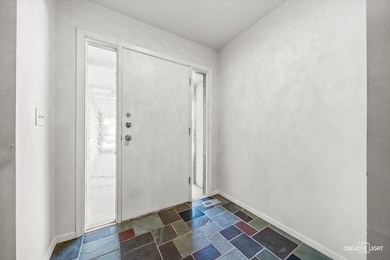
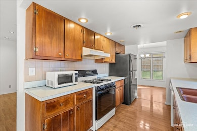
About This Home
Welcome to this inviting ranch home in the northwest corner of Boulder Hill, with Fox River views and a comfortable layout. Check out the bright living space that feels warm and cozy, with tons of natural light and a smooth flow between rooms. The kitchen and dining areas make everyday living easy and entertaining effortless. Two separate sliders lead to the backyard/concrete patios. Three roomy bedrooms and two full baths provide flexibility for guests, a home office, or hobbies. Enjoy the convenience of single-level living and a practical floorplan that makes sense. The water heater was replaced in 2023. Outside, you'll find a spacious yard and nearby parks, shops, and restaurants, giving you the best of both convenience and community. Commuters will love the easy access to the tollway, and nature lovers, athletes and water lovers will appreciate the scenic Fox River just steps away. Come see why this home checks all the boxes for affordability, comfort, location, and value.
Listing Agent
eXp Realty Brokerage Phone: (630) 673-7704 License #475210617 Listed on: 10/30/2025

Open House Schedule
-
Saturday, November 01, 202511:00 am to 1:00 pm11/1/2025 11:00:00 AM +00:0011/1/2025 1:00:00 PM +00:00Add to Calendar
Home Details
Home Type
- Single Family
Est. Annual Taxes
- $6,509
Year Built
- Built in 1968
Lot Details
- 0.29 Acre Lot
- Corner Lot
Parking
- 2 Car Garage
- Driveway
Home Design
- Ranch Style House
- Asphalt Roof
Interior Spaces
- 1,816 Sq Ft Home
- Living Room
- Family or Dining Combination
Kitchen
- Gas Oven
- Range
- Microwave
- Dishwasher
Flooring
- Carpet
- Laminate
Bedrooms and Bathrooms
- 3 Bedrooms
- 3 Potential Bedrooms
- 2 Full Bathrooms
Laundry
- Laundry Room
- Dryer
- Washer
Schools
- Boulder Hill Elementary School
- Thompson Junior High School
- Oswego High School
Utilities
- Central Air
- Heating System Uses Natural Gas
Community Details
- Boulder Hill Subdivision
Listing and Financial Details
- Homeowner Tax Exemptions
Map
Home Values in the Area
Average Home Value in this Area
Tax History
| Year | Tax Paid | Tax Assessment Tax Assessment Total Assessment is a certain percentage of the fair market value that is determined by local assessors to be the total taxable value of land and additions on the property. | Land | Improvement |
|---|---|---|---|---|
| 2024 | $6,509 | $88,226 | $23,158 | $65,068 |
| 2023 | $5,949 | $78,076 | $20,494 | $57,582 |
| 2022 | $5,949 | $72,968 | $19,153 | $53,815 |
| 2021 | $5,845 | $69,493 | $18,241 | $51,252 |
| 2020 | $5,655 | $66,820 | $17,539 | $49,281 |
| 2019 | $5,654 | $65,854 | $17,539 | $48,315 |
| 2018 | $5,155 | $60,091 | $16,004 | $44,087 |
| 2017 | $4,986 | $55,383 | $14,750 | $40,633 |
| 2016 | $4,592 | $50,810 | $13,532 | $37,278 |
| 2015 | $4,414 | $47,047 | $12,530 | $34,517 |
| 2014 | -- | $45,237 | $12,048 | $33,189 |
| 2013 | -- | $47,618 | $12,682 | $34,936 |
Property History
| Date | Event | Price | List to Sale | Price per Sq Ft |
|---|---|---|---|---|
| 10/30/2025 10/30/25 | For Sale | $285,000 | 0.0% | $157 / Sq Ft |
| 10/30/2025 10/30/25 | Price Changed | $285,000 | -- | $157 / Sq Ft |
Purchase History
| Date | Type | Sale Price | Title Company |
|---|---|---|---|
| Warranty Deed | $222,000 | First American Title |
Mortgage History
| Date | Status | Loan Amount | Loan Type |
|---|---|---|---|
| Open | $165,000 | Purchase Money Mortgage |
Source: Midwest Real Estate Data (MRED)
MLS Number: 12504141
APN: 03-05-276-001
Disclaimer: Certain information contained herein is derived from information provided by parties other than Homes.com. All information provided is deemed reliable, but is not guaranteed to be accurate and should be independently verified.
![]() Based on information submitted to the MLS GRID. All data is obtained from various sources and may not have been verified by broker or MLS GRID. Supplied Open House Information is subject to change without notice. All information should be independently reviewed and verified for accuracy. Properties may or may not be listed by the office/agent presenting the information. Some IDX listings have been excluded from this website.
Based on information submitted to the MLS GRID. All data is obtained from various sources and may not have been verified by broker or MLS GRID. Supplied Open House Information is subject to change without notice. All information should be independently reviewed and verified for accuracy. Properties may or may not be listed by the office/agent presenting the information. Some IDX listings have been excluded from this website.
The Digital Millennium Copyright Act of 1998, 17 U.S.C. § 512 (the “DMCA”) provides recourse for copyright owners who believe that material appearing on the Internet infringes their rights under U.S. copyright law. If you believe in good faith that any content or material made available in connection with our website or services infringes your copyright, you (or your agent) may send us a notice requesting that the content or material be removed, or access to it blocked.
Notices must be sent in writing by email to DMCAnotice@MLSGrid.com.
The DMCA requires that your notice of alleged copyright infringement include the following information:
(1) description of the copyrighted work that is the subject of claimed infringement;
(2) description of the alleged infringing content and information sufficient to permit us to locate the content;
(3) contact information for you, including your address, telephone number and email address;
(4) a statement by you that you have a good faith belief that the content in the manner complained of is not authorized by the copyright owner, or its agent, or by the operation of any law;
(5) a statement by you, signed under penalty of perjury, that the information in the notification is accurate and that you have the authority to enforce the copyrights that are claimed to be infringed; and
(6) a physical or electronic signature of the copyright owner or a person authorized to act on the copyright owner’s behalf. Failure to include all of the above information may result in the delay of the processing of your complaint.
- 17 Knollwood Dr Unit 3
- 29 Briarcliff Rd
- 133 Autumn Rdg Dr
- 117 Boulder Hill Pass Unit 117
- 34 Pembrooke Rd
- 19 Wyndham Dr Unit 10
- 125 S Main St
- 3 Scarsdale Rd
- 15 Crescent Ct
- 54 Sierra Rd
- 1 Highway 30
- 8 Clay Ct
- 170 Montgomery Rd
- 106 Braeburn Rd
- 124 Heathgate Rd
- 1375 Manning Ave
- 1417 Manning Ave
- 37 Fallcreek Cir
- 1342 Oak Ridge Ln
- 23 Old Post Rd
- 50 Boulder Hill Pass
- 1500 Briarcliff Rd
- 101 Harbor Dr Unit C
- 2500 Light Rd Unit 106
- 834 Victoria Dr
- 2028 Kevin Dr
- 512 Montgomery Rd
- 1154 Rathbone Ave
- 205 Springbrook Trail S
- 266 Springbrook Trail S
- 182 N Adams St
- 130 Warren Ave
- 425 Ingleside Ave
- 112 Chicago Rd Unit B
- 205 Tinana St
- 782 Oxbow Ave
- 509 Fifth St Unit lower
- 160 Washington St
- 1175 Reading Dr
- 1037 Howell Place