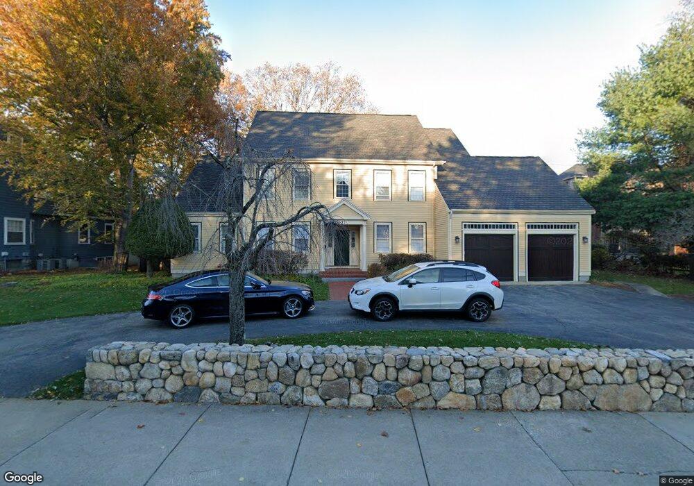
21 Forest St Lexington, MA 02421
Munroe Hill NeighborhoodEstimated Value: $2,683,412 - $3,388,000
6
Beds
4
Baths
4,787
Sq Ft
$629/Sq Ft
Est. Value
About This Home
This home is located at 21 Forest St, Lexington, MA 02421 and is currently estimated at $3,010,103, approximately $628 per square foot. 21 Forest St is a home located in Middlesex County with nearby schools including Fiske Elementary School, William Diamond Middle School, and Lexington High School.
Ownership History
Date
Name
Owned For
Owner Type
Purchase Details
Closed on
Dec 30, 2008
Sold by
Wright Cameron D and Chesney Wright D
Bought by
Hwang Dong Hyun and Hwang Mikyung Jung
Current Estimated Value
Home Financials for this Owner
Home Financials are based on the most recent Mortgage that was taken out on this home.
Original Mortgage
$600,000
Outstanding Balance
$398,836
Interest Rate
6.17%
Mortgage Type
Purchase Money Mortgage
Estimated Equity
$2,611,267
Purchase Details
Closed on
Mar 1, 1993
Sold by
Lincoln Pk Rt
Bought by
Wright Cameron D and Chesney Wright D
Create a Home Valuation Report for This Property
The Home Valuation Report is an in-depth analysis detailing your home's value as well as a comparison with similar homes in the area
Home Values in the Area
Average Home Value in this Area
Purchase History
| Date | Buyer | Sale Price | Title Company |
|---|---|---|---|
| Hwang Dong Hyun | $1,500,000 | -- | |
| Wright Cameron D | $750,000 | -- |
Source: Public Records
Mortgage History
| Date | Status | Borrower | Loan Amount |
|---|---|---|---|
| Open | Wright Cameron D | $343,000 | |
| Closed | Wright Cameron D | $350,000 | |
| Closed | Wright Cameron D | $150,000 | |
| Open | Hwang Dong Hyun | $600,000 | |
| Previous Owner | Wright Cameron D | $350,000 |
Source: Public Records
Tax History Compared to Growth
Tax History
| Year | Tax Paid | Tax Assessment Tax Assessment Total Assessment is a certain percentage of the fair market value that is determined by local assessors to be the total taxable value of land and additions on the property. | Land | Improvement |
|---|---|---|---|---|
| 2025 | $28,789 | $2,354,000 | $1,073,000 | $1,281,000 |
| 2024 | $28,469 | $2,324,000 | $1,022,000 | $1,302,000 |
| 2023 | $26,806 | $2,062,000 | $929,000 | $1,133,000 |
| 2022 | $25,889 | $1,876,000 | $844,000 | $1,032,000 |
| 2021 | $26,147 | $1,817,000 | $804,000 | $1,013,000 |
| 2020 | $24,307 | $1,730,000 | $804,000 | $926,000 |
| 2019 | $23,566 | $1,669,000 | $766,000 | $903,000 |
| 2018 | $22,480 | $1,572,000 | $709,000 | $863,000 |
| 2017 | $21,865 | $1,509,000 | $675,000 | $834,000 |
| 2016 | $22,849 | $1,565,000 | $620,000 | $945,000 |
| 2015 | $21,874 | $1,472,000 | $564,000 | $908,000 |
| 2014 | $22,071 | $1,423,000 | $505,000 | $918,000 |
Source: Public Records
Map
Nearby Homes
- 32 Forest St
- 1894 Massachusetts Ave
- 1900 Massachusetts Ave
- 42 Winthrop Rd
- 30 Meriam St Unit 30
- 48 Sherburne Rd
- 20 Loring Rd
- 49 Fletcher Ave
- 45 Hancock St
- 93 Bedford St Unit 210
- 93 Bedford St Unit 308
- 93 Bedford St Unit 101
- 18 Hill St
- 71 Woburn St
- 14 Percy Rd
- 42 Grapevine Ave
- 92 Hill St
- 143 Lincoln St
- 2 Percy Rd
- 17 Prospect Hill Rd