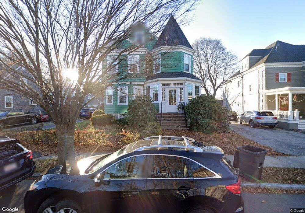
21 Goss Ave Melrose, MA 02176
Melrose East Side NeighborhoodEstimated Value: $808,000 - $1,035,000
4
Beds
3
Baths
1,645
Sq Ft
$559/Sq Ft
Est. Value
About This Home
This home is located at 21 Goss Ave, Melrose, MA 02176 and is currently estimated at $920,250, approximately $559 per square foot. 21 Goss Ave is a home located in Middlesex County with nearby schools including Winthrop Elementary School, Hoover Elementary School, and Lincoln Elementary School.
Ownership History
Date
Name
Owned For
Owner Type
Purchase Details
Closed on
May 22, 1995
Sold by
Molloy Robert S and Way Kathleen
Bought by
Lew Thomas F and Lew Meloney M
Current Estimated Value
Home Financials for this Owner
Home Financials are based on the most recent Mortgage that was taken out on this home.
Original Mortgage
$193,800
Interest Rate
8.34%
Mortgage Type
Purchase Money Mortgage
Purchase Details
Closed on
Aug 2, 1993
Sold by
Carpenter A Lauren and Carpenter Christopher
Bought by
Molloy Robert S and Way Kathleen
Home Financials for this Owner
Home Financials are based on the most recent Mortgage that was taken out on this home.
Original Mortgage
$181,000
Interest Rate
7.32%
Mortgage Type
Purchase Money Mortgage
Create a Home Valuation Report for This Property
The Home Valuation Report is an in-depth analysis detailing your home's value as well as a comparison with similar homes in the area
Home Values in the Area
Average Home Value in this Area
Purchase History
| Date | Buyer | Sale Price | Title Company |
|---|---|---|---|
| Lew Thomas F | $204,000 | -- | |
| Molloy Robert S | $194,000 | -- |
Source: Public Records
Mortgage History
| Date | Status | Borrower | Loan Amount |
|---|---|---|---|
| Open | Molloy Robert S | $190,000 | |
| Closed | Molloy Robert S | $193,800 | |
| Previous Owner | Molloy Robert S | $181,000 | |
| Previous Owner | Molloy Robert S | $50,000 |
Source: Public Records
Tax History
| Year | Tax Paid | Tax Assessment Tax Assessment Total Assessment is a certain percentage of the fair market value that is determined by local assessors to be the total taxable value of land and additions on the property. | Land | Improvement |
|---|---|---|---|---|
| 2025 | $76 | $772,600 | $480,900 | $291,700 |
| 2024 | $7,472 | $752,500 | $467,200 | $285,300 |
| 2023 | $7,518 | $721,500 | $453,400 | $268,100 |
| 2022 | $7,140 | $675,500 | $412,200 | $263,300 |
| 2021 | $6,931 | $633,000 | $384,700 | $248,300 |
| 2020 | $6,997 | $633,200 | $384,700 | $248,500 |
| 2019 | $6,225 | $575,900 | $343,500 | $232,400 |
| 2018 | $5,980 | $527,800 | $295,400 | $232,400 |
| 2017 | $5,702 | $483,200 | $274,800 | $208,400 |
| 2016 | $5,858 | $475,100 | $274,800 | $200,300 |
| 2015 | $5,689 | $439,000 | $261,100 | $177,900 |
| 2014 | $5,465 | $411,500 | $233,600 | $177,900 |
Source: Public Records
Map
Nearby Homes
- 30 Wheeler Ave
- 187 Laurel St
- 71-73 Grove St
- 65 Beacon St
- 1 Mill Rd
- 31 Temple St
- 77 Lynde St
- 236-238 Main St
- 109 Linden Rd
- 9 Elmcrest Cir
- 0 S Mountain Avenue & O Cargil
- 8 Crystal St Unit 2
- 8 Crystal St Unit 3
- 333 Main St
- 340 Main St Unit 508
- 340 Main St Unit 206
- 70 Sylvan St
- 128 Green St Unit 128
- 244 Main St
- 59 Dexter Rd
Your Personal Tour Guide
Ask me questions while you tour the home.