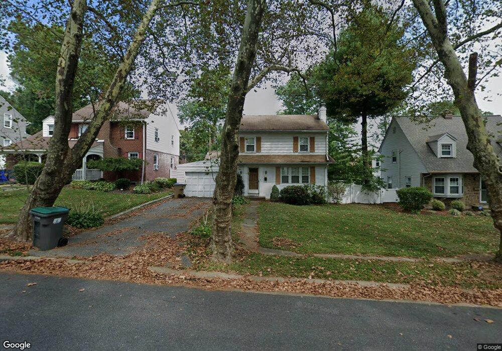
21 Hillside Rd Claymont, DE 19703
Estimated Value: $306,000 - $344,000
3
Beds
2
Baths
1,352
Sq Ft
$246/Sq Ft
Est. Value
About This Home
This home is located at 21 Hillside Rd, Claymont, DE 19703 and is currently estimated at $333,098, approximately $246 per square foot. 21 Hillside Rd is a home located in New Castle County with nearby schools including Maple Lane Elementary School, Pierre S. Dupont Middle School, and Brandywine High School.
Ownership History
Date
Name
Owned For
Owner Type
Purchase Details
Closed on
Oct 29, 2021
Sold by
Hevalow Jonathan David and Hevalow Karen Rose
Bought by
Harris Jesse M
Current Estimated Value
Home Financials for this Owner
Home Financials are based on the most recent Mortgage that was taken out on this home.
Original Mortgage
$223,250
Outstanding Balance
$204,256
Interest Rate
2.88%
Mortgage Type
New Conventional
Estimated Equity
$128,842
Purchase Details
Closed on
Sep 30, 1993
Bought by
Hevalow Jonathan D and Iacono Karen R
Create a Home Valuation Report for This Property
The Home Valuation Report is an in-depth analysis detailing your home's value as well as a comparison with similar homes in the area
Home Values in the Area
Average Home Value in this Area
Purchase History
| Date | Buyer | Sale Price | Title Company |
|---|---|---|---|
| Harris Jesse M | -- | None Available | |
| Hevalow Jonathan D | $130,000 | -- |
Source: Public Records
Mortgage History
| Date | Status | Borrower | Loan Amount |
|---|---|---|---|
| Open | Harris Jesse M | $223,250 |
Source: Public Records
Tax History Compared to Growth
Tax History
| Year | Tax Paid | Tax Assessment Tax Assessment Total Assessment is a certain percentage of the fair market value that is determined by local assessors to be the total taxable value of land and additions on the property. | Land | Improvement |
|---|---|---|---|---|
| 2024 | $2,070 | $54,400 | $11,600 | $42,800 |
| 2023 | $1,892 | $54,400 | $11,600 | $42,800 |
| 2022 | $1,924 | $54,400 | $11,600 | $42,800 |
| 2021 | $1,924 | $54,400 | $11,600 | $42,800 |
| 2020 | $1,925 | $54,400 | $11,600 | $42,800 |
| 2019 | $1,978 | $54,400 | $11,600 | $42,800 |
| 2018 | $207 | $54,400 | $11,600 | $42,800 |
| 2017 | $1,810 | $54,400 | $11,600 | $42,800 |
| 2016 | $1,810 | $54,400 | $11,600 | $42,800 |
| 2015 | -- | $54,400 | $11,600 | $42,800 |
| 2014 | $1,664 | $54,400 | $11,600 | $42,800 |
Source: Public Records
Map
Nearby Homes
- 2603 Lincoln Ave
- 2205 Lincoln Ave
- 2810 Green St
- 307 New York Ave
- 707 Parkside Blvd
- 48 4th Ave
- 8 Commonwealth Ave
- 814 Naudain Ave
- 3 Forrest Ave
- 1904 Garfield Ave
- 1810 Garfield Ave
- 3048 Greenshire Ave
- 45 Osage Rd
- 12 Wistar St
- 1249 Parish Ave
- 3858 Green St
- 11 Woodsway Rd
- 20 E Dickens Rd
- 120 Hilldale Ct
- 29 N Cliffe Dr