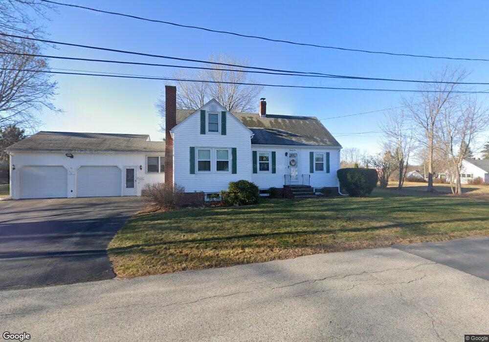
21 Libby Ave Westbrook, ME 04092
Estimated Value: $375,000 - $508,000
3
Beds
1
Bath
1,548
Sq Ft
$292/Sq Ft
Est. Value
About This Home
This home is located at 21 Libby Ave, Westbrook, ME 04092 and is currently estimated at $452,567, approximately $292 per square foot. 21 Libby Ave is a home located in Cumberland County with nearby schools including Westbrook High School, Breakwater School, and The Little Dolphin School Foundation.
Ownership History
Date
Name
Owned For
Owner Type
Purchase Details
Closed on
Feb 7, 2022
Sold by
Westbrook City Of
Bought by
Plourde Brian and Knudsen-Plourde Nancy F
Current Estimated Value
Purchase Details
Closed on
Jul 5, 2017
Sold by
Plourde Nancy K
Bought by
Plourde Nancy F and Plourde Brian P
Create a Home Valuation Report for This Property
The Home Valuation Report is an in-depth analysis detailing your home's value as well as a comparison with similar homes in the area
Purchase History
| Date | Buyer | Sale Price | Title Company |
|---|---|---|---|
| Plourde Brian | -- | None Available | |
| Plourde Nancy F | -- | -- |
Source: Public Records
Tax History
| Year | Tax Paid | Tax Assessment Tax Assessment Total Assessment is a certain percentage of the fair market value that is determined by local assessors to be the total taxable value of land and additions on the property. | Land | Improvement |
|---|---|---|---|---|
| 2023 | $4,957 | $297,200 | $97,800 | $199,400 |
| 2022 | $4,482 | $247,600 | $81,500 | $166,100 |
| 2021 | $4,354 | $244,200 | $78,100 | $166,100 |
| 2020 | $3,832 | $244,200 | $78,100 | $166,100 |
| 2019 | $4,361 | $244,200 | $78,100 | $166,100 |
| 2018 | $3,589 | $205,000 | $67,900 | $137,100 |
| 2017 | $3,870 | $205,000 | $67,900 | $137,100 |
| 2016 | $3,772 | $205,000 | $67,900 | $137,100 |
| 2015 | $3,682 | $205,000 | $67,900 | $137,100 |
| 2014 | $3,526 | $205,000 | $67,900 | $137,100 |
| 2013 | $3,526 | $205,000 | $67,900 | $137,100 |
Source: Public Records
Map
Nearby Homes
- 20 Taggart Ave
- 141 Rochester St
- 22 Berkeley St
- 311 Main St
- 383 Main St
- 11 Anderson Ave
- 21 Clover Ln Unit 109
- 21 Clover Ln Unit 210
- 21 Clover Ln Unit 306
- 21 Clover Ln Unit 112
- 21 Clover Ln Unit 407
- 21 Clover Ln Unit 207
- 21 Clover Ln Unit 212
- 21 Clover Ln Unit 107
- 21 Clover Ln Unit 209
- 21 Clover Ln Unit 104
- 26 King St Unit 1
- 500 Spring St
- Lot 15&16 Chickadee Ln
- 18 Cole St
Your Personal Tour Guide
Ask me questions while you tour the home.