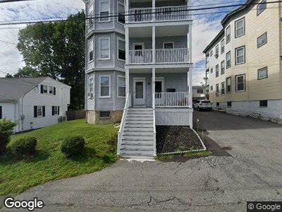
21 Sturgis St Woburn, MA 01801
Downtown Woburn NeighborhoodEstimated Value: $955,000 - $1,259,000
6
Beds
3
Baths
3,844
Sq Ft
$278/Sq Ft
Est. Value
About This Home
This home is located at 21 Sturgis St, Woburn, MA 01801 and is currently estimated at $1,068,667, approximately $278 per square foot. 21 Sturgis St is a home located in Middlesex County with nearby schools including Malcolm White Elementary School, Daniel L. Joyce Middle School, and Woburn High School.
Ownership History
Date
Name
Owned For
Owner Type
Purchase Details
Closed on
Nov 21, 2018
Sold by
Anthony S Buscemi T S and Anthony Noyes
Bought by
Noyes Christopher C
Current Estimated Value
Home Financials for this Owner
Home Financials are based on the most recent Mortgage that was taken out on this home.
Original Mortgage
$282,352
Interest Rate
4.9%
Mortgage Type
New Conventional
Purchase Details
Closed on
Apr 23, 2018
Sold by
Buscemi Anthony S Est and Noyes
Bought by
Anthony S Buscemi T S and Anthony Noyes
Purchase Details
Closed on
May 19, 2010
Sold by
Buscemi Anthoney S and Busceme Anthony
Bought by
Buscemi Anthony S and Buscemi Jane C
Purchase Details
Closed on
Mar 6, 1963
Bought by
Buscemi Anthony S
Create a Home Valuation Report for This Property
The Home Valuation Report is an in-depth analysis detailing your home's value as well as a comparison with similar homes in the area
Home Values in the Area
Average Home Value in this Area
Purchase History
| Date | Buyer | Sale Price | Title Company |
|---|---|---|---|
| Noyes Christopher C | $352,941 | -- | |
| Noyes Christopher C | $352,941 | -- | |
| Anthony S Buscemi T S | -- | -- | |
| Anthony S Buscemi T | -- | -- | |
| Buscemi Anthony S | -- | -- | |
| Buscemi Anthony S | -- | -- | |
| Buscemi Anthony S | -- | -- |
Source: Public Records
Mortgage History
| Date | Status | Borrower | Loan Amount |
|---|---|---|---|
| Open | Noyes Christopher C | $377,000 | |
| Closed | Noyes Christopher C | $282,352 |
Source: Public Records
Tax History Compared to Growth
Tax History
| Year | Tax Paid | Tax Assessment Tax Assessment Total Assessment is a certain percentage of the fair market value that is determined by local assessors to be the total taxable value of land and additions on the property. | Land | Improvement |
|---|---|---|---|---|
| 2025 | $6,858 | $803,100 | $313,100 | $490,000 |
| 2024 | $6,249 | $775,300 | $298,200 | $477,100 |
| 2023 | $6,330 | $727,600 | $271,100 | $456,500 |
| 2022 | $5,841 | $625,400 | $235,700 | $389,700 |
| 2021 | $5,730 | $614,200 | $224,500 | $389,700 |
| 2020 | $5,006 | $537,100 | $224,500 | $312,600 |
| 2019 | $4,561 | $480,100 | $213,800 | $266,300 |
| 2018 | $4,443 | $449,200 | $196,100 | $253,100 |
| 2017 | $4,509 | $453,600 | $186,800 | $266,800 |
| 2016 | $4,269 | $424,800 | $174,600 | $250,200 |
| 2015 | $4,204 | $413,400 | $163,200 | $250,200 |
| 2014 | $4,143 | $396,800 | $163,200 | $233,600 |
Source: Public Records
Map
Nearby Homes
- 31 Arlington Rd Unit 1-6
- 14 Caulfield Rd
- 69 Warren Ave
- 10 Beacon St Unit 105
- 10 Beacon St Unit 101
- 8 Church Ave
- 35 Prospect St Unit 313
- 63 Prospect St Unit 2
- 7 Prospect St
- 8 Veteran Rd
- 17 Highland St Unit 2
- 15 Highland St
- 37 Montvale Ave Unit 6
- 24 Everett St
- 85 Winn St
- 30 Auburn St
- 7 Davis St
- 24 Leonard St
- 19 Davis St
- 6 Garden St