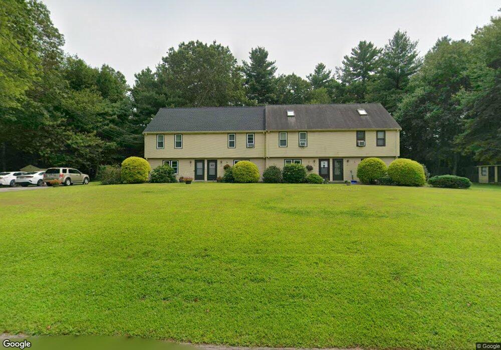
21 Taylor Ct Unit 4, 21 Norton, MA 02766
Estimated Value: $318,009 - $346,000
2
Beds
2
Baths
950
Sq Ft
$351/Sq Ft
Est. Value
About This Home
This home is located at 21 Taylor Ct Unit 4, 21, Norton, MA 02766 and is currently estimated at $333,252, approximately $350 per square foot. 21 Taylor Ct Unit 4, 21 is a home located in Bristol County with nearby schools including J.C. Solmonese Elementary School, Henri A. Yelle Elementary School, and Norton Middle School.
Ownership History
Date
Name
Owned For
Owner Type
Purchase Details
Closed on
Dec 18, 2020
Sold by
Faria Bryan and Faria Sarah P
Bought by
Sands Courtney and Goodman Chad
Current Estimated Value
Home Financials for this Owner
Home Financials are based on the most recent Mortgage that was taken out on this home.
Original Mortgage
$156,000
Outstanding Balance
$138,887
Interest Rate
2.7%
Mortgage Type
New Conventional
Estimated Equity
$194,365
Purchase Details
Closed on
Sep 28, 2012
Sold by
Donlon Kelly and Donlon Ryan
Bought by
Faria Bryan and Faria Sarah P
Home Financials for this Owner
Home Financials are based on the most recent Mortgage that was taken out on this home.
Original Mortgage
$90,400
Interest Rate
3.62%
Mortgage Type
New Conventional
Purchase Details
Closed on
Dec 6, 2004
Sold by
Bramwell Michelle J
Bought by
Donlon Ryan and Donlon Kelly
Home Financials for this Owner
Home Financials are based on the most recent Mortgage that was taken out on this home.
Original Mortgage
$180,400
Interest Rate
5.69%
Mortgage Type
Purchase Money Mortgage
Create a Home Valuation Report for This Property
The Home Valuation Report is an in-depth analysis detailing your home's value as well as a comparison with similar homes in the area
Home Values in the Area
Average Home Value in this Area
Purchase History
| Date | Buyer | Sale Price | Title Company |
|---|---|---|---|
| Sands Courtney | $195,000 | None Available | |
| Faria Bryan | $113,000 | -- | |
| Donlon Ryan | $225,500 | -- |
Source: Public Records
Mortgage History
| Date | Status | Borrower | Loan Amount |
|---|---|---|---|
| Open | Sands Courtney | $156,000 | |
| Previous Owner | Faria Bryan | $90,400 | |
| Previous Owner | Donlon Ryan | $180,400 |
Source: Public Records
Tax History
| Year | Tax Paid | Tax Assessment Tax Assessment Total Assessment is a certain percentage of the fair market value that is determined by local assessors to be the total taxable value of land and additions on the property. | Land | Improvement |
|---|---|---|---|---|
| 2025 | $34 | $263,200 | $0 | $263,200 |
| 2024 | $3,311 | $255,700 | $0 | $255,700 |
| 2023 | $3,005 | $231,300 | $0 | $231,300 |
| 2022 | $2,925 | $205,100 | $0 | $205,100 |
| 2021 | $2,841 | $190,300 | $0 | $190,300 |
| 2020 | $2,794 | $188,800 | $0 | $188,800 |
| 2019 | $2,694 | $180,800 | $0 | $180,800 |
| 2018 | $2,650 | $174,800 | $0 | $174,800 |
| 2017 | $2,565 | $166,900 | $0 | $166,900 |
| 2016 | $2,555 | $163,700 | $0 | $163,700 |
| 2015 | $2,806 | $182,300 | $0 | $182,300 |
| 2014 | $2,724 | $177,200 | $0 | $177,200 |
Source: Public Records
Map
Nearby Homes
- 143 Oak St Unit 10
- 5 Village Way Unit C
- 4 Village Way Unit F
- 10 Walter St
- 101 Godfrey Dr Unit 101
- 343 Godfrey Dr
- 71 Richardson Ave
- 8 Country Cir
- 2 Edgewater Dr Unit 2
- 5 Robin Cir Unit 5
- 2 Oak St Unit 2B
- 451R Gilbert St
- 157 Mansfield Ave Unit 27
- 157 Mansfield Ave Unit 14
- 345 Richardson Ave
- 933 Pleasant St
- 250 Mansfield Ave Unit 11
- 123 Pike Ave
- 108 S Worcester St
- 180 Pike Ave
Your Personal Tour Guide
Ask me questions while you tour the home.