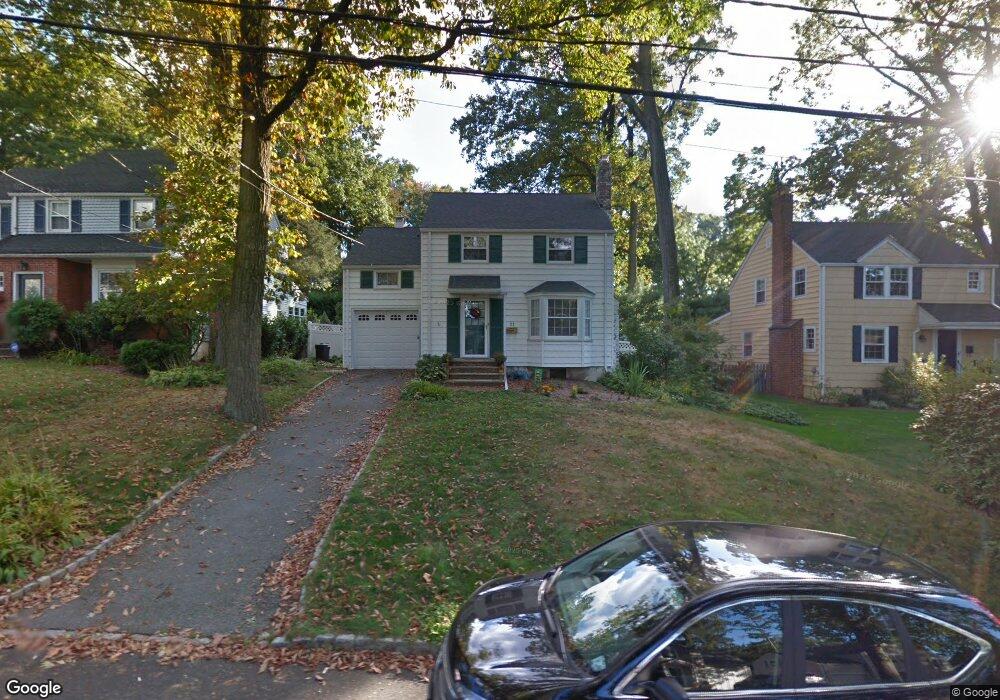
21 Westland Rd Cedar Grove, NJ 07009
Estimated Value: $674,874 - $822,000
--
Bed
--
Bath
1,248
Sq Ft
$580/Sq Ft
Est. Value
About This Home
This home is located at 21 Westland Rd, Cedar Grove, NJ 07009 and is currently estimated at $723,969, approximately $580 per square foot. 21 Westland Rd is a home located in Essex County with nearby schools including Cedar Grove High School, St Catherine Of Siena School, and Our Lady of the Lake School.
Ownership History
Date
Name
Owned For
Owner Type
Purchase Details
Closed on
Jun 22, 2011
Sold by
Rodgers Mark G and Rodgers Judith P
Bought by
Scarpa Michael
Current Estimated Value
Home Financials for this Owner
Home Financials are based on the most recent Mortgage that was taken out on this home.
Original Mortgage
$335,000
Outstanding Balance
$230,834
Interest Rate
4.62%
Mortgage Type
Purchase Money Mortgage
Estimated Equity
$493,135
Purchase Details
Closed on
Jun 27, 2005
Sold by
Sisbarro Otto
Bought by
Rodgers Mark and Rodgers Judith
Home Financials for this Owner
Home Financials are based on the most recent Mortgage that was taken out on this home.
Original Mortgage
$350,000
Interest Rate
5.73%
Mortgage Type
New Conventional
Create a Home Valuation Report for This Property
The Home Valuation Report is an in-depth analysis detailing your home's value as well as a comparison with similar homes in the area
Home Values in the Area
Average Home Value in this Area
Purchase History
| Date | Buyer | Sale Price | Title Company |
|---|---|---|---|
| Scarpa Michael | $420,000 | New Jersey Title Ins Co | |
| Rodgers Mark | $454,000 | -- |
Source: Public Records
Mortgage History
| Date | Status | Borrower | Loan Amount |
|---|---|---|---|
| Open | Scarpa Michael | $335,000 | |
| Previous Owner | Rodgers Mark | $350,000 |
Source: Public Records
Tax History Compared to Growth
Tax History
| Year | Tax Paid | Tax Assessment Tax Assessment Total Assessment is a certain percentage of the fair market value that is determined by local assessors to be the total taxable value of land and additions on the property. | Land | Improvement |
|---|---|---|---|---|
| 2025 | $9,960 | $381,600 | $237,200 | $144,400 |
| 2024 | $9,960 | $381,600 | $237,200 | $144,400 |
| 2022 | $9,784 | $381,600 | $237,200 | $144,400 |
| 2021 | $9,666 | $381,600 | $237,200 | $144,400 |
| 2020 | $9,807 | $381,600 | $237,200 | $144,400 |
| 2019 | $9,582 | $381,600 | $237,200 | $144,400 |
| 2018 | $9,143 | $381,600 | $237,200 | $144,400 |
| 2017 | $9,044 | $381,600 | $237,200 | $144,400 |
| 2016 | $8,765 | $381,600 | $237,200 | $144,400 |
| 2015 | $8,563 | $381,600 | $237,200 | $144,400 |
| 2014 | $8,388 | $381,600 | $237,200 | $144,400 |
Source: Public Records
Map
Nearby Homes
- 57 Elmwood Rd
- 71 Westland Rd
- 106 Pompton Ave
- 12 Linden Ave
- 127 Harper Terrace
- 142 Pompton Ave
- 31 Martin Rd
- 1 Claridge Dr Unit 806
- 1 Claridge Dr Unit 123
- 1 Claridge Dr Unit 503
- 1 Claridge Dr Unit 726
- 1 Claridge Dr Unit 310
- 1 Claridge Dr Unit 723
- 2 Claridge Dr 3lw
- 2 Claridge Dr 3iw
- 2 Claridge Dr 8lw
- 2 Claridge Dr 7lw
- 2 Claridge Dr 1fw
- 31 Westover Rd
- 51 Essex Rd