Estimated Value: $168,376 - $203,000
3
Beds
2
Baths
1,370
Sq Ft
$136/Sq Ft
Est. Value
About This Home
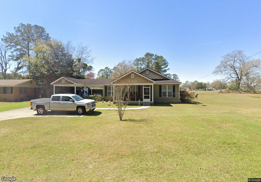
This home is located at 210 Brookside Dr, Adel, GA 31620 and is currently estimated at $186,094, approximately $135 per square foot. 210 Brookside Dr is a home located in Cook County with nearby schools including Cook Primary School, Cook Elementary School, and Cook County Middle School.
Ownership History
Date
Name
Owned For
Owner Type
Purchase Details
Closed on
Jan 5, 2009
Sold by
Register Jon D
Bought by
Moody Mary C
Current Estimated Value
Purchase Details
Closed on
Apr 26, 2007
Sold by
Best Built Custom Homes Ll
Bought by
Register Jon D and Register Shanya W
Purchase Details
Closed on
Oct 16, 2006
Sold by
Caldwell & Scarboro Llc
Bought by
Best Built Custom Homes Llc
Create a Home Valuation Report for This Property
The Home Valuation Report is an in-depth analysis detailing your home's value as well as a comparison with similar homes in the area
Home Values in the Area
Average Home Value in this Area
Purchase History
| Date | Buyer | Sale Price | Title Company |
|---|---|---|---|
| Moody Mary C | $115,000 | -- | |
| Register Jon D | $100,000 | -- | |
| Best Built Custom Homes Llc | $17,000 | -- |
Source: Public Records
Tax History
| Year | Tax Paid | Tax Assessment Tax Assessment Total Assessment is a certain percentage of the fair market value that is determined by local assessors to be the total taxable value of land and additions on the property. | Land | Improvement |
|---|---|---|---|---|
| 2025 | $1,616 | $55,401 | $6,801 | $48,600 |
| 2024 | $1,724 | $53,985 | $5,376 | $48,609 |
| 2023 | $1,487 | $46,796 | $4,800 | $41,996 |
| 2022 | $1,487 | $46,796 | $4,800 | $41,996 |
| 2021 | $1,335 | $39,430 | $4,800 | $34,630 |
| 2020 | $1,335 | $39,430 | $4,800 | $34,630 |
| 2019 | $1,336 | $39,430 | $4,800 | $34,630 |
| 2018 | $1,392 | $39,430 | $4,800 | $34,630 |
| 2017 | $1,342 | $39,430 | $4,800 | $34,630 |
| 2016 | $1,176 | $39,430 | $4,800 | $34,630 |
| 2015 | $1,176 | $39,430 | $4,800 | $34,630 |
| 2014 | $1,176 | $39,430 | $4,800 | $34,630 |
| 2013 | -- | $39,430 | $4,800 | $34,630 |
Source: Public Records
Map
Nearby Homes
- 211 S Gordon Ave
- 317 Brookside Dr
- 609 E 4th St
- 509 E 8th St
- 322 Magnolia Dr
- 708 Town And Country Dr
- 411 S Hutchinson Ave
- 315 Newton Dr
- 804 S Forrest Ave
- 701 Gloria St
- 806 S Forrest Ave
- 507 S Poplar St
- 814 N Cleveland Ave
- 309 Wayne St
- 526 E Mitchell St
- 413 Honeysuckle Way
- 321 Spanish Moss Ln
- 513 Spanish Moss Ln
- 625 Coxstill Rd
- 729 W 7th St
- 216 Brookside Dr
- 213 S Forrest Ave
- 215 S Forrest Ave
- tba Forrest Ave
- 209 Brookside Dr
- 201 Brookside Dr
- 515 E 6th St
- 301 S Forrest Ave
- 200 Brookside Dr
- 300 Brookside Dr
- 301 Brookside Dr
- 201 S Forrest Ave
- 305 S Forrest Ave S
- 507 E 6th St
- 302 S Forrest Ave
- 307 Brookside Dr
- 115 Brookside Dr
- 309 S Forrest Ave
- 308 Brookside Dr
- 504 E 6th St
Your Personal Tour Guide
Ask me questions while you tour the home.