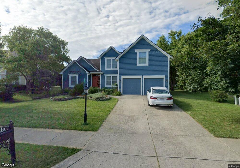
210 Delaneys Cir Powell, OH 43065
Estimated Value: $574,714 - $630,000
4
Beds
3
Baths
2,603
Sq Ft
$227/Sq Ft
Est. Value
About This Home
This home is located at 210 Delaneys Cir, Powell, OH 43065 and is currently estimated at $591,179, approximately $227 per square foot. 210 Delaneys Cir is a home located in Delaware County with nearby schools including Tyler Run Elementary School, Olentangy Liberty Middle School, and Olentangy Liberty High School.
Ownership History
Date
Name
Owned For
Owner Type
Purchase Details
Closed on
Mar 13, 1995
Sold by
Ryland Group Inc
Bought by
Rader Susan and Jervey Thomas O
Current Estimated Value
Home Financials for this Owner
Home Financials are based on the most recent Mortgage that was taken out on this home.
Original Mortgage
$128,400
Interest Rate
7.13%
Mortgage Type
New Conventional
Create a Home Valuation Report for This Property
The Home Valuation Report is an in-depth analysis detailing your home's value as well as a comparison with similar homes in the area
Home Values in the Area
Average Home Value in this Area
Purchase History
| Date | Buyer | Sale Price | Title Company |
|---|---|---|---|
| Rader Susan | $198,800 | -- |
Source: Public Records
Mortgage History
| Date | Status | Borrower | Loan Amount |
|---|---|---|---|
| Closed | Rader Susan | $128,400 |
Source: Public Records
Tax History
| Year | Tax Paid | Tax Assessment Tax Assessment Total Assessment is a certain percentage of the fair market value that is determined by local assessors to be the total taxable value of land and additions on the property. | Land | Improvement |
|---|---|---|---|---|
| 2024 | $9,951 | $189,910 | $35,840 | $154,070 |
| 2023 | $9,989 | $189,910 | $35,840 | $154,070 |
| 2022 | $8,843 | $133,290 | $26,290 | $107,000 |
| 2021 | $8,235 | $122,020 | $26,290 | $95,730 |
| 2020 | $8,264 | $122,020 | $26,290 | $95,730 |
| 2019 | $7,092 | $108,610 | $23,910 | $84,700 |
| 2018 | $7,174 | $108,610 | $23,910 | $84,700 |
| 2017 | $3,076 | $95,380 | $19,600 | $75,780 |
| 2016 | $6,760 | $95,380 | $19,600 | $75,780 |
| 2015 | $6,151 | $95,380 | $19,600 | $75,780 |
| 2014 | $6,519 | $99,750 | $19,600 | $80,150 |
| 2013 | $6,466 | $96,680 | $19,640 | $77,040 |
Source: Public Records
Map
Nearby Homes
- 424 Whitaker Ave S
- 1937 Liberty St
- 97 Murphys Crossing Dr
- 255 Winter Hill Place
- 120 S Liberty St
- 18 Murphys View Place Unit I18
- 471 Commons Dr Unit 471
- 104 Encore Park Bend
- 130 Barrington Place
- 149 Chedworth Row
- 170 Barrington Place
- 10010 Beckford Ct
- 22 Brookehill Dr
- 9406 Cadogan Ct
- 149 Trail Edge Cir
- 3899 Hampshire Ave
- 22 Liberty Ridge Ave
- 2672 Sawmill Reserve Dr Unit 2672
- 4933 Emerald Lakes Blvd Unit 4903
- 9529 Wayne Brown Dr
- 200 Delaneys Cir
- 220 Delaneys Cir
- 245 Delaneys Cir
- 230 Delaneys Cir
- 201 Delaneys Cir
- 254 Whitaker Ave S
- 251 Tree Haven Ave
- 253 Whitaker Ave S
- 240 Delaneys Cir
- 255 Delaneys Cir
- 264 Whitaker Ave S
- 250 Delaneys Cir
- 261 Tree Haven Ave
- 263 Whitaker Ave S
- 404 Bethany Ave
- 265 Delaneys Cir
- 260 Delaneys Cir
- 274 Whitaker Ave S
- 271 Tree Haven Ave
- 273 Whitaker Ave S
Your Personal Tour Guide
Ask me questions while you tour the home.