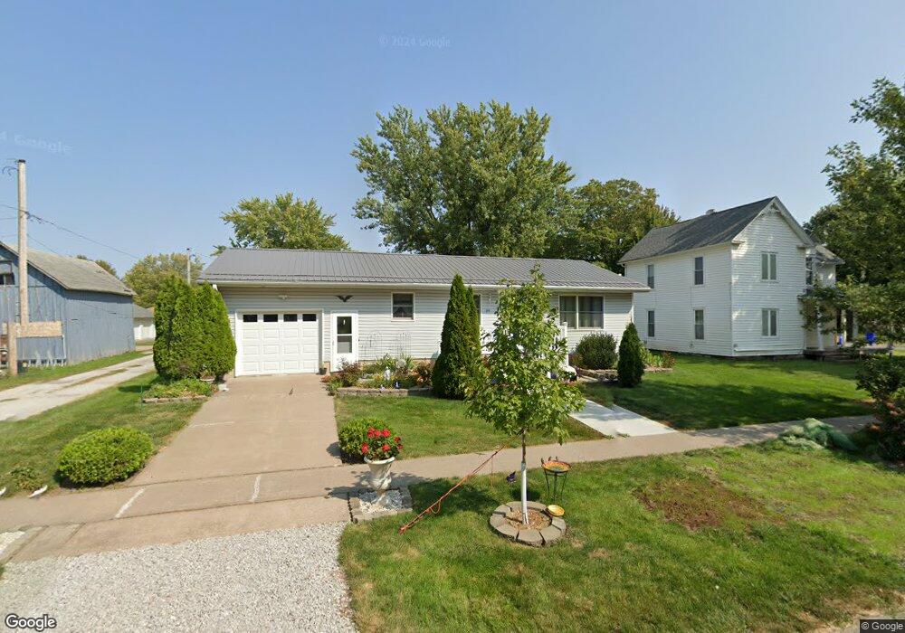
210 E Elm St Lone Tree, IA 52755
Estimated Value: $175,000 - $265,000
3
Beds
2
Baths
1,022
Sq Ft
$215/Sq Ft
Est. Value
About This Home
This home is located at 210 E Elm St, Lone Tree, IA 52755 and is currently estimated at $219,315, approximately $214 per square foot. 210 E Elm St is a home located in Johnson County with nearby schools including Lone Tree Elementary School and Lone Tree Junior/Senior High School.
Ownership History
Date
Name
Owned For
Owner Type
Purchase Details
Closed on
May 27, 2021
Sold by
Moore Robert
Bought by
Vangorkom Drew
Current Estimated Value
Purchase Details
Closed on
Oct 25, 2008
Sold by
Flake Ronald J and Flake Rachelle
Bought by
Herring Betty J
Home Financials for this Owner
Home Financials are based on the most recent Mortgage that was taken out on this home.
Original Mortgage
$121,000
Interest Rate
5.95%
Mortgage Type
Purchase Money Mortgage
Create a Home Valuation Report for This Property
The Home Valuation Report is an in-depth analysis detailing your home's value as well as a comparison with similar homes in the area
Purchase History
| Date | Buyer | Sale Price | Title Company |
|---|---|---|---|
| Vangorkom Drew | $177,500 | None Available | |
| Herring Betty J | $132,000 | None Available |
Source: Public Records
Mortgage History
| Date | Status | Borrower | Loan Amount |
|---|---|---|---|
| Previous Owner | Herring Betty J | $121,000 |
Source: Public Records
Tax History
| Year | Tax Paid | Tax Assessment Tax Assessment Total Assessment is a certain percentage of the fair market value that is determined by local assessors to be the total taxable value of land and additions on the property. | Land | Improvement |
|---|---|---|---|---|
| 2025 | $2,116 | $188,000 | $27,900 | $160,100 |
| 2024 | $21 | $177,100 | $27,900 | $149,200 |
| 2023 | $2,070 | $177,100 | $27,900 | $149,200 |
| 2022 | $2,046 | $140,200 | $22,100 | $118,100 |
| 2021 | $2,146 | $140,200 | $22,100 | $118,100 |
| 2020 | $2,146 | $140,200 | $22,100 | $118,100 |
| 2019 | $1,926 | $140,200 | $22,100 | $118,100 |
| 2018 | $1,890 | $124,500 | $22,100 | $102,400 |
| 2017 | $1,894 | $124,500 | $22,100 | $102,400 |
| 2016 | $1,810 | $117,500 | $22,100 | $95,400 |
| 2015 | $1,810 | $117,500 | $22,100 | $95,400 |
| 2014 | $2,018 | $129,700 | $22,100 | $107,600 |
Source: Public Records
Map
Nearby Homes
- 305 S Riggs St
- 407 E Elm St
- 500 S Center St
- 221 W Commercial St
- 210 W Mapel Dr
- 763 N Perkins St
- 25840 Golden Oak Ln Lot 1
- 25838 Golden Oak Ln Lot 7
- 25836 Golden Oak Ln Lot 8
- 25832 Golden Oak Ln Lot 12
- 25736 Golden Pond Ln Se Lot 17
- 25738 Golden Pond Ln Se Lot 16
- 25824 Golden Oak Ln Lot 9
- 1092 Walnut Ave Unit 209
- 1092 Walnut Ave Unit 301
- 1092 Walnut Ave Unit 117 Bld E
- 1092 Walnut Ave Unit 114 Bld D
- 207 Short St
- Lot 2 116th Cir
- 404 Main St
- 212 E Elm St
- 105 S Riggs St
- 108 S Center St
- 110 S Center St
- 106 S Center St
- 201 S Riggs St
- 207 E Jayne St
- 205 E Elm St
- 211 E Jayne St
- 205 E Jayne St
- 300 E Elm St
- 200 S Center St
- 205 S Riggs St
- 201 E Jayne St
- 301 E Jayne St
- 301 E Jayne St Unit 1 and 2
- 301 E Elm St
- 304 E Elm St
- 303 E Jayne St
- 207 S Riggs St
Your Personal Tour Guide
Ask me questions while you tour the home.