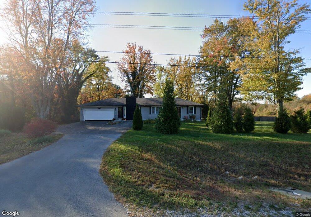
210 E State Road 256 Austin, IN 47102
Estimated Value: $246,000 - $301,000
3
Beds
2
Baths
2,106
Sq Ft
$127/Sq Ft
Est. Value
About This Home
This home is located at 210 E State Road 256, Austin, IN 47102 and is currently estimated at $268,465, approximately $127 per square foot. 210 E State Road 256 is a home located in Scott County with nearby schools including Austin Elementary School, Austin Middle School, and Austin High School.
Ownership History
Date
Name
Owned For
Owner Type
Purchase Details
Closed on
Dec 15, 2014
Sold by
Blevins Kyle R and Blevins Jessica L
Bought by
State Of Indiana
Current Estimated Value
Purchase Details
Closed on
Jun 2, 2010
Sold by
Turner Lonnie Michael
Bought by
Blevins Kyle R and Blevins Jessica L
Home Financials for this Owner
Home Financials are based on the most recent Mortgage that was taken out on this home.
Original Mortgage
$96,697
Interest Rate
5.5%
Mortgage Type
FHA
Purchase Details
Closed on
May 24, 2010
Sold by
Turner Lonnie Michael and Spicer Ruthie
Bought by
Turner Lonnie Michael
Home Financials for this Owner
Home Financials are based on the most recent Mortgage that was taken out on this home.
Original Mortgage
$96,697
Interest Rate
5.5%
Mortgage Type
FHA
Create a Home Valuation Report for This Property
The Home Valuation Report is an in-depth analysis detailing your home's value as well as a comparison with similar homes in the area
Home Values in the Area
Average Home Value in this Area
Purchase History
| Date | Buyer | Sale Price | Title Company |
|---|---|---|---|
| State Of Indiana | -- | None Available | |
| State Of Indiana | -- | None Available | |
| Blevins Kyle R | -- | None Available | |
| Turner Lonnie Michael | -- | None Available |
Source: Public Records
Mortgage History
| Date | Status | Borrower | Loan Amount |
|---|---|---|---|
| Previous Owner | Blevins Kyle R | $96,697 |
Source: Public Records
Tax History Compared to Growth
Tax History
| Year | Tax Paid | Tax Assessment Tax Assessment Total Assessment is a certain percentage of the fair market value that is determined by local assessors to be the total taxable value of land and additions on the property. | Land | Improvement |
|---|---|---|---|---|
| 2024 | $1,617 | $149,500 | $27,400 | $122,100 |
| 2023 | $1,598 | $147,200 | $27,400 | $119,800 |
| 2022 | $1,466 | $150,300 | $27,400 | $122,900 |
| 2021 | $1,348 | $140,000 | $27,400 | $112,600 |
| 2020 | $1,209 | $120,800 | $27,400 | $93,400 |
| 2019 | $1,092 | $116,600 | $27,400 | $89,200 |
| 2018 | $958 | $108,500 | $22,500 | $86,000 |
| 2017 | $903 | $108,300 | $22,500 | $85,800 |
| 2016 | $923 | $107,400 | $22,500 | $84,900 |
| 2014 | $789 | $95,000 | $23,700 | $71,300 |
| 2013 | $789 | $95,000 | $23,700 | $71,300 |
Source: Public Records
Map
Nearby Homes
- 3095 N Coffee Pot Rd
- 1062 E State Road 256
- 2653 N Coffee Pot Rd
- 329 E Cutshall Rd
- 232 E Main St
- 746 Goodin Dr
- 748 Goodin Dr
- 5038 S US Highway 31
- 220 Mann Ave
- 4198 S Us Highway 31
- 569 Broadway St
- 255 N Church St
- 92 Stonybrook Dr
- 60 Factory Dr
- 1153 Clay St
- 1212 Mann Ave
- 1105 Pearl St
- 0 U S 31
- 1671 Burns Ct
- 1020 N Church St
- 177 E State Road 256
- 128 E State Road 256
- 135 E State Road 256
- 261 E State Road 256
- 468 E State Road 256
- 3017 N Coffee Pot Rd
- 3230 N Coffee Pot Rd
- 3297 N Coffee Pot Rd
- 3237 Coffee Pot Rd
- 3209 N Coffee Pot Rd
- 3183 N Coffee Pot Rd
- 807 E State Road 256
- 432 W State Road 256
- 353 E Cutshall Rd
- 467 W State Road 256
- 0 N Bass Ln Unit 201501601
- 0 N Bass Ln Unit 201401406
- 2522 N Bass Ln
- 2523 N Bass Ln
- 2603, 2523, 252 N Bass Ln