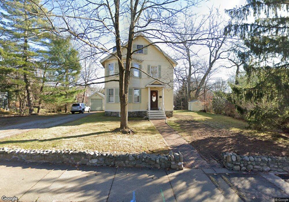
210 Grove St Auburndale, MA 02466
Auburndale NeighborhoodEstimated Value: $1,208,000 - $1,384,361
3
Beds
2
Baths
1,643
Sq Ft
$779/Sq Ft
Est. Value
About This Home
This home is located at 210 Grove St, Auburndale, MA 02466 and is currently estimated at $1,279,340, approximately $778 per square foot. 210 Grove St is a home located in Middlesex County with nearby schools including Williams Elementary School, Charles E Brown Middle School, and Newton South High School.
Ownership History
Date
Name
Owned For
Owner Type
Purchase Details
Closed on
Jul 24, 2007
Sold by
Gaines Joanne E
Bought by
Alvarez Iraida J and Weiss Steven E
Current Estimated Value
Home Financials for this Owner
Home Financials are based on the most recent Mortgage that was taken out on this home.
Original Mortgage
$414,400
Outstanding Balance
$259,554
Interest Rate
6.54%
Mortgage Type
Purchase Money Mortgage
Estimated Equity
$1,019,786
Create a Home Valuation Report for This Property
The Home Valuation Report is an in-depth analysis detailing your home's value as well as a comparison with similar homes in the area
Home Values in the Area
Average Home Value in this Area
Purchase History
| Date | Buyer | Sale Price | Title Company |
|---|---|---|---|
| Alvarez Iraida J | $518,000 | -- |
Source: Public Records
Mortgage History
| Date | Status | Borrower | Loan Amount |
|---|---|---|---|
| Open | Alvarez Iraida J | $414,400 |
Source: Public Records
Tax History Compared to Growth
Tax History
| Year | Tax Paid | Tax Assessment Tax Assessment Total Assessment is a certain percentage of the fair market value that is determined by local assessors to be the total taxable value of land and additions on the property. | Land | Improvement |
|---|---|---|---|---|
| 2025 | $9,004 | $918,800 | $851,600 | $67,200 |
| 2024 | $8,706 | $892,000 | $826,800 | $65,200 |
| 2023 | $8,188 | $804,300 | $630,400 | $173,900 |
| 2022 | $7,834 | $744,700 | $583,700 | $161,000 |
| 2021 | $7,559 | $702,500 | $550,700 | $151,800 |
| 2020 | $7,334 | $702,500 | $550,700 | $151,800 |
| 2019 | $7,127 | $682,000 | $534,700 | $147,300 |
| 2018 | $6,836 | $631,800 | $490,300 | $141,500 |
| 2017 | $6,628 | $596,000 | $462,500 | $133,500 |
| 2016 | $6,339 | $557,000 | $432,200 | $124,800 |
| 2015 | $6,044 | $520,600 | $403,900 | $116,700 |
Source: Public Records
Map
Nearby Homes
- 27 Oakwood Rd
- 17 Lasell St
- 283 Melrose St
- 224 Auburn St Unit 224
- 224 Auburn St Unit A
- 2202 Commonwealth Ave Unit 2
- 2202 Commonwealth Ave Unit 1
- 226 Auburn St Unit 226
- 283 Woodland Rd
- 1754 Washington St
- 17 Deforest Rd
- 13 Weir St
- 1639 Washington St
- 62-64 Rowe St Unit B
- 2084 Washington St
- 17 Gilbert St
- 51 Bourne St
- 1640 Commonwealth Ave
- 10 Lorraine Cir
- 17 Crescent St