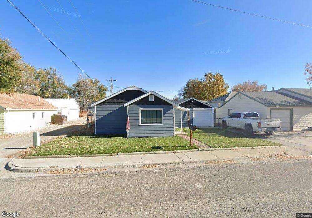
210 N 11th St Worland, WY 82401
Estimated Value: $137,273 - $158,000
2
Beds
1
Bath
1,068
Sq Ft
$139/Sq Ft
Est. Value
About This Home
This home is located at 210 N 11th St, Worland, WY 82401 and is currently estimated at $148,091, approximately $138 per square foot. 210 N 11th St is a home located in Washakie County with nearby schools including East Side Elementary School, South Side Elementary School, and West Side Elementary School.
Ownership History
Date
Name
Owned For
Owner Type
Purchase Details
Closed on
Sep 30, 2024
Sold by
Casdorph Levi A and Casdorph Akira S
Bought by
Doan Thao T and Sy Henry
Current Estimated Value
Home Financials for this Owner
Home Financials are based on the most recent Mortgage that was taken out on this home.
Original Mortgage
$109,600
Outstanding Balance
$105,231
Interest Rate
5.66%
Mortgage Type
New Conventional
Estimated Equity
$42,860
Purchase Details
Closed on
Nov 12, 2021
Sold by
Moises Vega Jr
Bought by
Casdorph Levi A and Casdorph Akira S
Home Financials for this Owner
Home Financials are based on the most recent Mortgage that was taken out on this home.
Original Mortgage
$103,030
Interest Rate
3.01%
Mortgage Type
New Conventional
Purchase Details
Closed on
Sep 23, 2016
Sold by
Vega Moses
Bought by
Vega Moises
Create a Home Valuation Report for This Property
The Home Valuation Report is an in-depth analysis detailing your home's value as well as a comparison with similar homes in the area
Home Values in the Area
Average Home Value in this Area
Purchase History
| Date | Buyer | Sale Price | Title Company |
|---|---|---|---|
| Doan Thao T | -- | None Listed On Document | |
| Casdorph Levi A | -- | None Listed On Document | |
| Vega Moises | -- | -- |
Source: Public Records
Mortgage History
| Date | Status | Borrower | Loan Amount |
|---|---|---|---|
| Open | Doan Thao T | $109,600 | |
| Previous Owner | Casdorph Levi A | $103,030 |
Source: Public Records
Tax History Compared to Growth
Tax History
| Year | Tax Paid | Tax Assessment Tax Assessment Total Assessment is a certain percentage of the fair market value that is determined by local assessors to be the total taxable value of land and additions on the property. | Land | Improvement |
|---|---|---|---|---|
| 2025 | $487 | $6,390 | $1,294 | $5,096 |
| 2024 | $624 | $8,192 | $1,659 | $6,533 |
| 2023 | $593 | $7,788 | $558 | $7,230 |
| 2022 | $534 | $7,013 | $558 | $6,455 |
| 2021 | $447 | $5,870 | $447 | $5,423 |
| 2020 | $571 | $7,499 | $2,185 | $5,314 |
| 2019 | $491 | $6,448 | $2,185 | $4,263 |
| 2018 | $474 | $6,221 | $1,710 | $4,511 |
| 2017 | $413 | $5,418 | $1,995 | $3,423 |
| 2016 | $391 | $5,131 | $1,805 | $3,326 |
| 2015 | -- | $4,335 | $1,805 | $2,530 |
| 2014 | -- | $4,496 | $1,995 | $2,501 |
Source: Public Records
Map
Nearby Homes
- 1015 Robertson Ave
- 1012 Pulliam Ave
- 1221 Pulliam Ave
- 1301 Pulliam Ave
- 1205 Coburn Ave
- 1300 Coburn Ave
- 814 Conant Ave
- 2396 U S 20
- 2386 U S 20
- 2366 U S 20
- 821 Obie Sue Ave
- 1701 Coburn Ave
- 1542 Cloud Peak Dr
- 408 S 16th St
- 520 Obie Sue Ave
- 624 S 5th St
- 501 Obie Sue Ave
- 739 S 13th St
- 2007 Harkins Ave
- 708 S 16th St
- 1105 Robertson Ave
- 202 N 11th St
- 212 N 11th St
- 209 N 11th St
- 1104 Pulliam Ave
- 209 N 11th St
- 215 N 11th St
- 1110 Pulliam Ave
- 1113 Robertson Ave
- 217 N 11th St
- 1116 Pulliam Ave
- 1016 Pulliam Ave
- 122 N 11th St
- 1117 Robertson Ave
- 1118 Pulliam Ave
- 1101 Pulliam Ave
- 1124 Pulliam Ave
- 114 N 11th St
- 1116 Robertson Ave
- 1105 Pulliam Ave