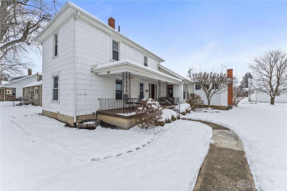
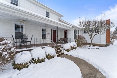
210 N Grant St Covington, OH 45318
Estimated payment $1,396/month
Highlights
- No HOA
- Walk-In Closet
- Bathroom on Main Level
- 2 Car Detached Garage
- Laundry Room
- Central Air
About This Home
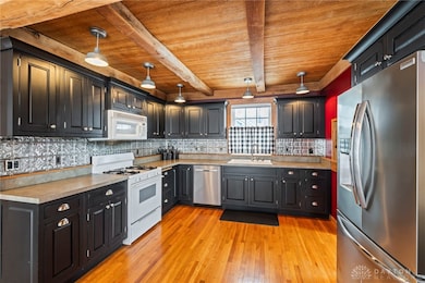
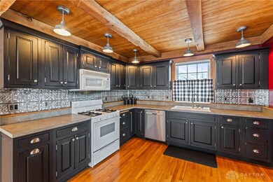
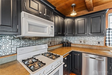
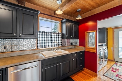
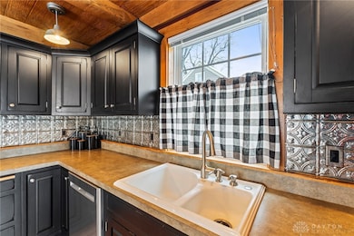
This 3-bedroom, 2.5-bath home stands out with personality you rarely see, offering a main-level primary suite with a cozy gas fireplace and private ensuite bathroom. Custom craftsmanship shines in the kitchen with an authentic wood ceiling and exposed beams that bring lasting warmth to the heart of the home. The well-planned layout includes a full bath upstairs, separate main-level laundry room, and a partial basement providing excellent storage. Outside, enjoy a partially fenced yard suited for everyday living, along with a detached 2-car garage. Ideally centralized and just steps from the school, a new community park, and uptown restaurants, this home blends comfort, practicality, and a walkable lifestyle, and the seller is including all kitchen appliances plus the washer and dryer for a true move-in-ready, turn-key experience.
Listing Agent
Nikki Angle
Keller Williams Home Town Rlty Brokerage Phone: 937-570-9489 License #2025004305 Listed on: 12/05/2025
Home Details
Home Type
- Single Family
Est. Annual Taxes
- $1,657
Year Built
- 1920
Lot Details
- 7,841 Sq Ft Lot
- Lot Dimensions are 132x60
- Partially Fenced Property
Parking
- 2 Car Detached Garage
Home Design
- Shingle Siding
- Asbestos
Interior Spaces
- 1,756 Sq Ft Home
- 2-Story Property
- Ceiling Fan
- Gas Fireplace
- Partial Basement
- Fire and Smoke Detector
Kitchen
- Range
- Microwave
- Dishwasher
- Laminate Countertops
- Disposal
Bedrooms and Bathrooms
- 3 Bedrooms
- Walk-In Closet
- Bathroom on Main Level
Laundry
- Laundry Room
- Dryer
- Washer
Utilities
- Central Air
- Heating System Uses Natural Gas
- Gas Water Heater
Community Details
- No Home Owners Association
Listing and Financial Details
- Assessor Parcel Number H19006960
Map
Home Values in the Area
Average Home Value in this Area
Tax History
| Year | Tax Paid | Tax Assessment Tax Assessment Total Assessment is a certain percentage of the fair market value that is determined by local assessors to be the total taxable value of land and additions on the property. | Land | Improvement |
|---|---|---|---|---|
| 2024 | $1,657 | $44,240 | $11,480 | $32,760 |
| 2023 | $1,657 | $44,240 | $11,480 | $32,760 |
| 2022 | $1,653 | $44,240 | $11,480 | $32,760 |
| 2021 | $1,372 | $34,020 | $8,820 | $25,200 |
| 2020 | $1,375 | $34,020 | $8,820 | $25,200 |
| 2019 | $1,381 | $34,020 | $8,820 | $25,200 |
| 2018 | $1,175 | $28,880 | $6,900 | $21,980 |
| 2017 | $1,196 | $28,880 | $6,900 | $21,980 |
| 2016 | $1,181 | $28,880 | $6,900 | $21,980 |
| 2015 | $1,087 | $27,760 | $6,620 | $21,140 |
| 2014 | $1,087 | $27,760 | $6,620 | $21,140 |
| 2013 | $1,047 | $27,760 | $6,620 | $21,140 |
Property History
| Date | Event | Price | List to Sale | Price per Sq Ft |
|---|---|---|---|---|
| 12/05/2025 12/05/25 | For Sale | $239,900 | -- | $137 / Sq Ft |
Purchase History
| Date | Type | Sale Price | Title Company |
|---|---|---|---|
| Warranty Deed | $115,000 | -- | |
| Warranty Deed | $27,666 | -- | |
| Deed | -- | -- |
Mortgage History
| Date | Status | Loan Amount | Loan Type |
|---|---|---|---|
| Open | $112,917 | FHA | |
| Previous Owner | $22,133 | New Conventional |
Source: Dayton REALTORS®
MLS Number: 948450
APN: H19006960
Disclaimer: Certain information contained herein is derived from information provided by parties other than Homes.com. All information provided is deemed reliable, but is not guaranteed to be accurate and should be independently verified.
![]() The information is being provided by Dayton Area Board of Realtors MLS. Information deemed reliable but not guaranteed. Information is provided for the consumer's personal, non-commercial use, and may not be used for any purpose other than the identification of potential properties for purchase. Copyright 2025 Dayton Area Board of Realtors MLS. All Rights Reserved.
The information is being provided by Dayton Area Board of Realtors MLS. Information deemed reliable but not guaranteed. Information is provided for the consumer's personal, non-commercial use, and may not be used for any purpose other than the identification of potential properties for purchase. Copyright 2025 Dayton Area Board of Realtors MLS. All Rights Reserved.
- 2200 Deerfield Crossing Unit 2222
- 1321 Fairfax Ave
- 90 Maryville Ln
- 620 Miami St
- 618 Miami St
- 1002 Park Ave
- 316 N College St
- 428 Wood St
- 2411 New Castle Dr
- 2401 Highland Ct
- 187 Westhaven Dr
- 1850 Towne Park Dr
- 1240 E Garbry Rd
- 2257 Shamrock Ln
- 1016 Eleanor Ave Unit 1016
- 1030 Office Redharvest Dr
- 1525 Mckaig Ave
- 1555 Windridge Place Unit D
- 833 Jefferson St
- 525 Lake St