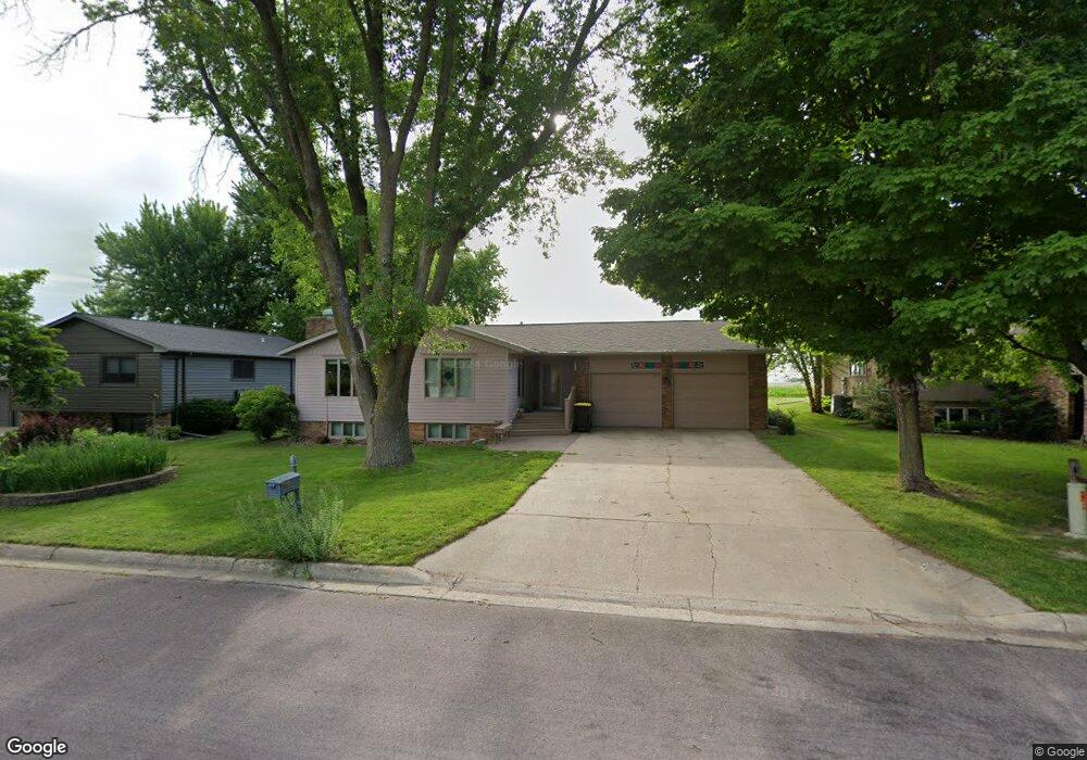
210 S 7th Ave E Truman, MN 56088
Estimated Value: $177,000 - $198,340
2
Beds
3
Baths
1,512
Sq Ft
$126/Sq Ft
Est. Value
About This Home
This home is located at 210 S 7th Ave E, Truman, MN 56088 and is currently estimated at $189,835, approximately $125 per square foot. 210 S 7th Ave E is a home located in Martin County with nearby schools including Truman Elementary School, Truman Secondary School, and St. Paul Lutheran School.
Ownership History
Date
Name
Owned For
Owner Type
Purchase Details
Closed on
Jan 19, 2021
Sold by
Sherman Joanne and Sherman Bradley
Bought by
Lightfoot Cole and Lightfoot Catherine
Current Estimated Value
Home Financials for this Owner
Home Financials are based on the most recent Mortgage that was taken out on this home.
Original Mortgage
$113,810
Outstanding Balance
$101,576
Interest Rate
2.71%
Mortgage Type
New Conventional
Estimated Equity
$88,259
Create a Home Valuation Report for This Property
The Home Valuation Report is an in-depth analysis detailing your home's value as well as a comparison with similar homes in the area
Purchase History
| Date | Buyer | Sale Price | Title Company |
|---|---|---|---|
| Lightfoot Cole | $119,800 | Jenkinson Abstract Company | |
| Sherman Joanne | -- | Jenkinson Abstract Company | |
| Lightfoot Cole Cole | $119,800 | -- |
Source: Public Records
Mortgage History
| Date | Status | Borrower | Loan Amount |
|---|---|---|---|
| Open | Lightfoot Cole | $113,810 | |
| Closed | Lightfoot Cole Cole | $119,800 |
Source: Public Records
Tax History
| Year | Tax Paid | Tax Assessment Tax Assessment Total Assessment is a certain percentage of the fair market value that is determined by local assessors to be the total taxable value of land and additions on the property. | Land | Improvement |
|---|---|---|---|---|
| 2025 | $3,074 | $203,100 | $7,100 | $196,000 |
| 2024 | $2,814 | $189,700 | $4,200 | $185,500 |
| 2023 | $3,050 | $188,300 | $2,800 | $185,500 |
| 2022 | $2,606 | $183,700 | $2,800 | $180,900 |
| 2021 | $2,140 | $135,600 | $2,800 | $132,800 |
| 2020 | $2,084 | $116,300 | $2,800 | $113,500 |
| 2019 | $2,112 | $116,300 | $2,800 | $113,500 |
| 2018 | $1,876 | $116,300 | $2,800 | $113,500 |
| 2017 | $1,838 | $80,600 | $2,088 | $78,512 |
| 2016 | $1,350 | $70,200 | $1,994 | $68,206 |
| 2015 | $855 | $46,000 | $1,746 | $44,254 |
| 2013 | $894 | $43,900 | $1,682 | $42,218 |
Source: Public Records
Map
Nearby Homes
- 225 S 7th Ave E Unit E
- 818 E 2nd St N
- 406 E Ciro St
- 518 E 2nd St N
- 506 E 2nd St N
- 206 N 1st Ave E
- 226 N Central Ave
- 2404 State Highway 15
- 413 N 1st Ave W
- 402 E 2nd St N
- 43637 State Highway 15
- 1958 State Highway 15
- 39904 State Highway 15
- 321 Oric St S
- 300th Ave
- TBD 300th Ave
- 74194 415th St
- 326 NW 1st St
- 405 Sparks Dr
- 1668 150th Ave
- 214 S 7th Ave E
- 206 S 7th Ave E
- 218 S 7th Ave E
- 205 S 7th Ave E
- 209 S 7th Ave E
- 705 E 1st St S
- 222 S 7th Ave E
- 222 S 7th Ave E
- 213 S 7th Ave E
- 217 S 7th Ave E
- 814 E 1st St S
- 210 S 6th Ave E
- 206 S 6th Ave E
- 214 S 6th Ave E
- 701 E 1st St S
- 710 E 1st St S
- 218 S 6th Ave E
- 221 S 7th Ave E
- 230 S 7th Ave E
- 302 S 6th Ave E
Your Personal Tour Guide
Ask me questions while you tour the home.