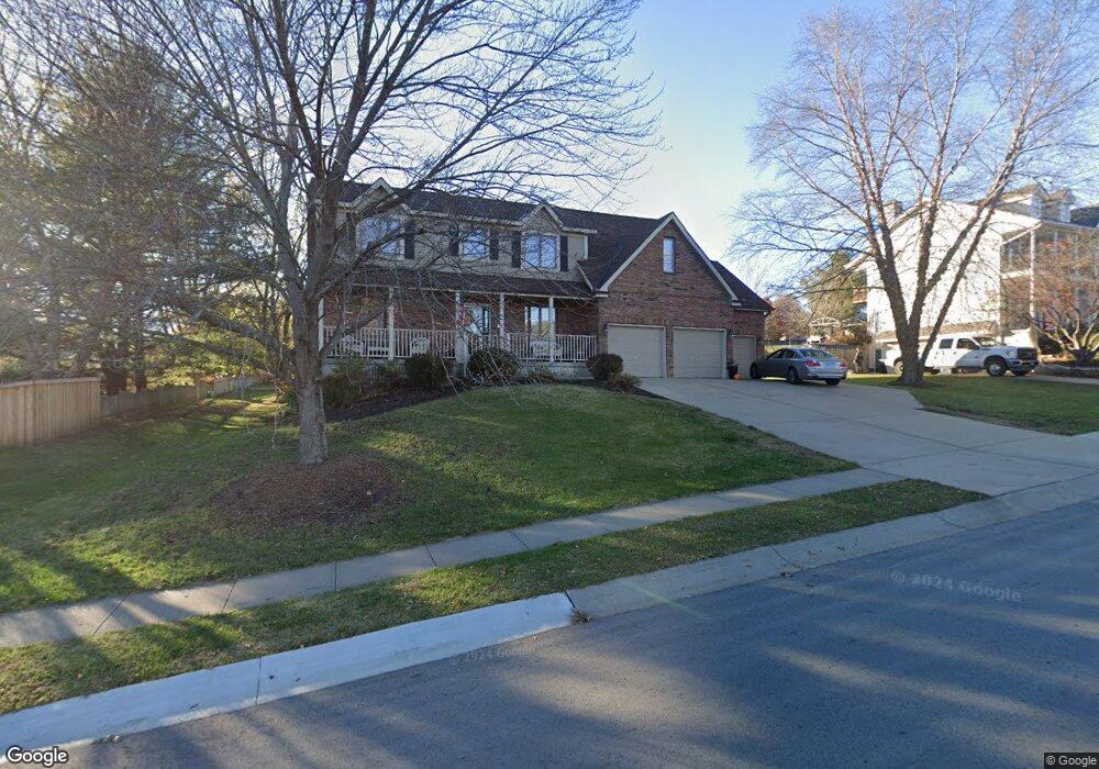
210 Southfork Rd Lansing, KS 66043
Estimated Value: $454,179 - $516,000
4
Beds
4
Baths
2,603
Sq Ft
$183/Sq Ft
Est. Value
About This Home
This home is located at 210 Southfork Rd, Lansing, KS 66043 and is currently estimated at $476,045, approximately $182 per square foot. 210 Southfork Rd is a home located in Leavenworth County with nearby schools including Lansing Elementary School, Lansing Middle 6-8, and Lansing High 9-12.
Ownership History
Date
Name
Owned For
Owner Type
Purchase Details
Closed on
Dec 1, 1999
Bought by
Lehman Michael N and Lehman Carol S
Current Estimated Value
Home Financials for this Owner
Home Financials are based on the most recent Mortgage that was taken out on this home.
Original Mortgage
$63,854
Interest Rate
7.75%
Mortgage Type
New Conventional
Create a Home Valuation Report for This Property
The Home Valuation Report is an in-depth analysis detailing your home's value as well as a comparison with similar homes in the area
Home Values in the Area
Average Home Value in this Area
Purchase History
| Date | Buyer | Sale Price | Title Company |
|---|---|---|---|
| Lehman Michael N | $3,351 | -- |
Source: Public Records
Mortgage History
| Date | Status | Borrower | Loan Amount |
|---|---|---|---|
| Closed | Lehman Michael N | $63,854 |
Source: Public Records
Tax History
| Year | Tax Paid | Tax Assessment Tax Assessment Total Assessment is a certain percentage of the fair market value that is determined by local assessors to be the total taxable value of land and additions on the property. | Land | Improvement |
|---|---|---|---|---|
| 2025 | $6,688 | $50,795 | $7,499 | $43,296 |
| 2024 | $6,438 | $49,300 | $7,499 | $41,801 |
| 2023 | $6,438 | $49,300 | $7,499 | $41,801 |
| 2022 | $6,151 | $44,540 | $7,121 | $37,419 |
| 2021 | $5,684 | $39,376 | $7,121 | $32,255 |
| 2020 | $5,475 | $37,329 | $7,121 | $30,208 |
| 2019 | $5,483 | $37,329 | $7,121 | $30,208 |
| 2018 | $5,240 | $35,708 | $7,121 | $28,587 |
| 2017 | $5,056 | $34,385 | $7,121 | $27,264 |
| 2016 | $5,058 | $34,385 | $7,121 | $27,264 |
| 2015 | $5,043 | $34,385 | $7,121 | $27,264 |
| 2014 | $4,794 | $33,379 | $7,121 | $26,258 |
Source: Public Records
Map
Nearby Homes
- 189 Canyon View Dr
- 111 Southfork Rd
- 875 Clearview Dr
- 1322 Rock Creek Ct
- 898 Clearview Dr
- 1221 S Desoto Rd
- 922 Southfork St
- 24431 139th St
- 13965 Mc Intyre Rd
- 811 4-H Rd
- 13788 McIntyre1 Rd
- 13788 Mcintyre Rd
- 13788 McIntyre2 Rd
- 26731 147th St
- 202 S Main St
- 124 S Main St
- 130 Hampton Ct
- 218 E Kay St
- 15683 Gilman Rd
- 20958 Ida St
- 200 Cottonwood Dr
- 208 Southfork Rd
- 202 Cottonwood Dr
- 181 Canyon View Dr
- 211 Southfork Rd
- 206 Southfork Rd
- 209 Southfork Rd
- 204 Cottonwood Dr
- 183 Canyon View Dr
- 201 Cottonwood Dr
- 203 Cottonwood Dr
- 204 Southfork Rd
- 168 Canyon View Dr
- 207 Southfork Rd
- 1423 Rock Creek Dr
- 185 Canyon View Dr
- 205 Cottonwood Dr
- 600 Cottonwood Dr
- 603 Rock Creek Dr
- 170 Canyon View Dr
Your Personal Tour Guide
Ask me questions while you tour the home.