Estimated Value: $356,000 - $397,000
3
Beds
2
Baths
1,871
Sq Ft
$200/Sq Ft
Est. Value
About This Home
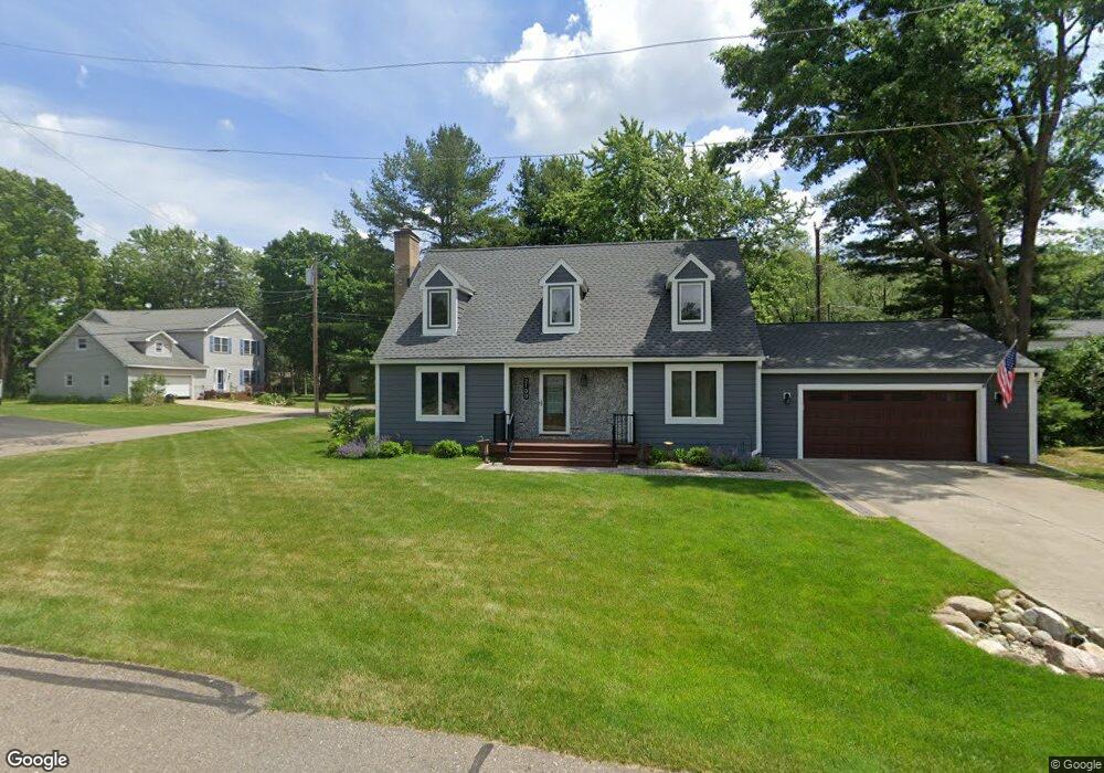
This home is located at 2100 Qualla Ave, Wixom, MI 48393 and is currently estimated at $374,927, approximately $200 per square foot. 2100 Qualla Ave is a home located in Oakland County with nearby schools including Loon Lake Elementary School, Sarah G. Banks Middle School, and Walled Lake Central High School.
Ownership History
Date
Name
Owned For
Owner Type
Purchase Details
Closed on
Aug 4, 2025
Sold by
Sturr Michael Joseph and Sturr Erin Renee
Bought by
Michael And Erin Sturr Revocable Living Trust and Sturr
Current Estimated Value
Purchase Details
Closed on
Aug 31, 2020
Sold by
Kansman Harry R and Kansman Delores M
Bought by
Sturr Michael Joseph and Sturr Erin Renee
Purchase Details
Closed on
May 2, 2019
Sold by
Kansman Harey R and Kansman Delores M
Bought by
Sturr Michael Joseph and Sturr Erin Rehee
Purchase Details
Closed on
Dec 15, 2010
Sold by
Kansman Harry R and Kansman Delores M
Bought by
Kansman Harry R and Kansman Delores M
Create a Home Valuation Report for This Property
The Home Valuation Report is an in-depth analysis detailing your home's value as well as a comparison with similar homes in the area
Home Values in the Area
Average Home Value in this Area
Purchase History
| Date | Buyer | Sale Price | Title Company |
|---|---|---|---|
| Michael And Erin Sturr Revocable Living Trust | -- | None Listed On Document | |
| Michael And Erin Sturr Revocable Living Trust | -- | None Listed On Document | |
| Sturr Michael Joseph | -- | Dfcu Title Agency Llc | |
| Sturr Michael Joseph | -- | None Available | |
| Kansman Harry R | -- | None Available | |
| Sturr Michael Joseph | -- | None Available | |
| Sturr Michael Joseph | $150,000 | None Available |
Source: Public Records
Mortgage History
| Date | Status | Borrower | Loan Amount |
|---|---|---|---|
| Closed | Sturr Michael Joseph | $0 |
Source: Public Records
Tax History Compared to Growth
Tax History
| Year | Tax Paid | Tax Assessment Tax Assessment Total Assessment is a certain percentage of the fair market value that is determined by local assessors to be the total taxable value of land and additions on the property. | Land | Improvement |
|---|---|---|---|---|
| 2025 | $3,834 | $180,350 | $0 | $0 |
| 2024 | $3,612 | $170,030 | $0 | $0 |
| 2023 | $3,423 | $158,860 | $0 | $0 |
| 2022 | $3,435 | $155,210 | $0 | $0 |
| 2021 | $3,308 | $138,210 | $0 | $0 |
| 2020 | $3,197 | $130,200 | $0 | $0 |
| 2019 | $3,321 | $128,370 | $0 | $0 |
| 2018 | $3,369 | $114,040 | $0 | $0 |
| 2017 | $3,326 | $111,300 | $0 | $0 |
| 2016 | $3,313 | $98,110 | $0 | $0 |
| 2015 | -- | $88,410 | $0 | $0 |
| 2014 | -- | $87,530 | $0 | $0 |
| 2011 | -- | $95,600 | $0 | $0 |
Source: Public Records
Map
Nearby Homes
- 1535 Kings Crown Ct
- 2160 Darnell St
- 2015 Lamella
- 2549 Benstein Rd
- 1599 Chanticlair Cir
- 1268 Amarillo St
- 1445 Mariposa Dr
- 1255 Andover Dr
- 1148 Lakeview Dr
- 1200 Drakeshire Dr
- 1338 Andover Cir
- 1179 Andover Cir Unit 48
- 1104 Andover Cir Unit 92
- 1470 Nightingale
- 2370 Roselawn St
- 2294 Calibouge Unit 31
- 2403 Terry St
- 1369 Flamingo
- 30210 Chesapeake Cir Unit 360
- 24202 Chesapeake Cir Unit 287