


2100 University Blvd Lima, OH 45805
Westgate NeighborhoodEstimated payment $961/month
Total Views
30,739
3
Beds
1.5
Baths
1,345
Sq Ft
$118
Price per Sq Ft
Highlights
- Hot Property
- No HOA
- Forced Air Heating and Cooling System
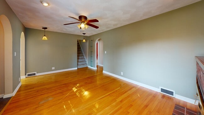
- Wood Flooring
- 2 Car Detached Garage
- Dining Room
About This Home
Welcome to 2100 University Blvd, a home that radiates charm and character in every corner. Nestled in Lima, Ohio, this inviting 3-bedroom, 1.5-bath residence offers 1,345 square feet of thoughtfully designed living space, enhanced by classic built-ins and warm architectural details. A second living area provides flexible options—perfect as a cozy den, creative workspace, or even a fourth bedroom. The two-car garage adds everyday convenience, while the waterproofed basement (completed in 2021) offers peace of mind and potential for additional storage or future finishing. Whether you're drawn to its timeless appeal or its practical layout, this home is ready to welcome you with comfort and personality.
Home Details
Home Type
- Single Family
Est. Annual Taxes
- $1,538
Year Built
- Built in 1941
Lot Details
- 8,146 Sq Ft Lot
Parking
- 2 Car Detached Garage
Home Design
- Block Foundation
Interior Spaces
- 1,345 Sq Ft Home
- 2-Story Property
- Family Room
- Living Room with Fireplace
- Dining Room
- Unfinished Basement
- Block Basement Construction
Kitchen
- Microwave
- Dishwasher
- Laminate Countertops
Flooring
- Wood
- Carpet
- Tile
Bedrooms and Bathrooms
- 3 Bedrooms
Laundry
- Dryer
- Washer
Utilities
- Forced Air Heating and Cooling System
- Heating System Uses Natural Gas
Community Details
- No Home Owners Association
Listing and Financial Details
- Assessor Parcel Number 36-2611-04-019.000
- $44 per year additional tax assessments
Matterport 3D Tour
Floorplans
Map
Create a Home Valuation Report for This Property
The Home Valuation Report is an in-depth analysis detailing your home's value as well as a comparison with similar homes in the area
Home Values in the Area
Average Home Value in this Area
Tax History
| Year | Tax Paid | Tax Assessment Tax Assessment Total Assessment is a certain percentage of the fair market value that is determined by local assessors to be the total taxable value of land and additions on the property. | Land | Improvement |
|---|---|---|---|---|
| 2024 | $1,538 | $42,950 | $6,970 | $35,980 |
| 2023 | $1,368 | $33,050 | $5,360 | $27,690 |
| 2022 | $1,376 | $33,050 | $5,360 | $27,690 |
| 2021 | $1,457 | $33,050 | $5,360 | $27,690 |
| 2020 | $1,430 | $28,740 | $5,110 | $23,630 |
| 2019 | $1,430 | $28,740 | $5,110 | $23,630 |
| 2018 | $1,410 | $28,740 | $5,110 | $23,630 |
| 2017 | $1,435 | $28,740 | $5,110 | $23,630 |
| 2016 | $1,449 | $28,740 | $5,110 | $23,630 |
| 2015 | $1,363 | $28,740 | $5,110 | $23,630 |
| 2014 | $1,363 | $26,610 | $5,080 | $21,530 |
| 2013 | $1,326 | $26,610 | $5,080 | $21,530 |
Source: Public Records
Property History
| Date | Event | Price | List to Sale | Price per Sq Ft |
|---|---|---|---|---|
| 10/17/2025 10/17/25 | Price Changed | $159,000 | 0.0% | $118 / Sq Ft |
| 10/17/2025 10/17/25 | For Sale | $159,000 | -2.5% | $118 / Sq Ft |
| 10/10/2025 10/10/25 | Pending | -- | -- | -- |
| 09/30/2025 09/30/25 | Price Changed | $163,000 | -4.1% | $121 / Sq Ft |
| 09/17/2025 09/17/25 | For Sale | $170,000 | -- | $126 / Sq Ft |
Source: West Central Association of REALTORS® (OH)
Purchase History
| Date | Type | Sale Price | Title Company |
|---|---|---|---|
| Warranty Deed | $77,500 | None Available | |
| Deed | $56,000 | -- | |
| Deed | $27,500 | -- |
Source: Public Records
Mortgage History
| Date | Status | Loan Amount | Loan Type |
|---|---|---|---|
| Open | $75,534 | FHA |
Source: Public Records
About the Listing Agent
Whether you are selling a home, purchasing a new one, curious about your home's value or looking for an investment property--I can help! I strive to provide excellent service for each of my buyers and sellers and my goal is to help you have a wonderful real estate transaction! I grew up in Allen County Ohio and after obtaining my Associates Degree in business, I moved away and lived in Virginia and Colorado. My love for the small towns of the Midwest brought me home to Ohio in 2007. My husband
Connie's Other Listings
-
$320,000 Pending
- 3 Beds
- 2 Baths
- 2,020 Sq Ft
Welcome to 8955 Lafayette Road—a beautifully renovated 3-bed, 2-bath farmhouse on 6.46 scenic acres. Blending rustic charm with modern updates, it features new flooring, appliances, and an open layout ideal for living and entertaining. Outside, enjoy a large barn with stalls and workshop, fenced pasture, shed, heated 2-car garage, and extensive parking. Efficient heating systems serve the home,
Connie Thompson Superior Plus Realtors
Source: West Central Association of REALTORS® (OH)
MLS Number: 308256
APN: 36-26-11-04-019.000
Nearby Homes
- 514 N Cable Rd
- 1753 Leland Ave
- 2050 W Market St
- 1703 W Wayne St
- 1719 Latham Ave
- 391 N Fernwood Dr
- 109 N Pears Ave
- 1912 Hillcrest Dr
- 858 Mackenzie Dr
- 1630 W Market St
- 918 Cornell Dr
- 234 S Westwood Dr
- 621 Fairfield Dr
- 1517 Allentown Rd
- 1508 Oakland Pkwy
- 1459 W Market St
- 120 S Woodlawn Ave
- 1880 Wendell Ave
- 102 Charwood Dr
- 2700 Lowell Ave
- 655 Columbia Dr Unit Westgate
- 2650 W Market St
- 232 S Rosedale Ave
- 819 E College Ave
- 901 W Market St
- 2916 Cletus Pkwy
- 706 W State St Unit 706
- 2901 Elijah Pkwy Unit B
- 2941 Elijah Pkwy
- 766 W Wayne St
- 739 W Wayne St Unit 3
- 527 Haller St
- 656 W Spring St
- 152 Pierre Place Unit 152
- 510 Cortlandt Ave
- 123 Pierre Place Unit 123
- 2275 N Cable Rd Unit 194
- 140A Hartford Ct Unit 140A
- 106 Hartford Ct Unit 106 Hartford Court
- 617 Heindel Ave