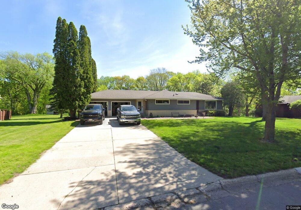
2102 Roe Crest Ct North Mankato, MN 56003
Estimated Value: $336,000 - $381,000
3
Beds
2
Baths
1,228
Sq Ft
$291/Sq Ft
Est. Value
About This Home
This home is located at 2102 Roe Crest Ct, North Mankato, MN 56003 and is currently estimated at $356,895, approximately $290 per square foot. 2102 Roe Crest Ct is a home located in Nicollet County with nearby schools including Hoover Elementary School, Dakota Meadows Middle School, and Mankato West Senior High School.
Ownership History
Date
Name
Owned For
Owner Type
Purchase Details
Closed on
Aug 30, 2024
Sold by
Looft Brian
Bought by
Pengilly Callie and Pengilly Trevor
Current Estimated Value
Home Financials for this Owner
Home Financials are based on the most recent Mortgage that was taken out on this home.
Original Mortgage
$255,000
Outstanding Balance
$252,293
Interest Rate
6.77%
Mortgage Type
New Conventional
Estimated Equity
$104,602
Create a Home Valuation Report for This Property
The Home Valuation Report is an in-depth analysis detailing your home's value as well as a comparison with similar homes in the area
Home Values in the Area
Average Home Value in this Area
Purchase History
| Date | Buyer | Sale Price | Title Company |
|---|---|---|---|
| Pengilly Callie | $340,000 | -- |
Source: Public Records
Mortgage History
| Date | Status | Borrower | Loan Amount |
|---|---|---|---|
| Open | Pengilly Callie | $255,000 |
Source: Public Records
Tax History Compared to Growth
Tax History
| Year | Tax Paid | Tax Assessment Tax Assessment Total Assessment is a certain percentage of the fair market value that is determined by local assessors to be the total taxable value of land and additions on the property. | Land | Improvement |
|---|---|---|---|---|
| 2025 | $4,646 | $375,900 | $115,600 | $260,300 |
| 2024 | $4,524 | $375,900 | $115,600 | $260,300 |
| 2023 | $4,040 | $354,800 | $115,600 | $239,200 |
| 2022 | $3,590 | $319,000 | $115,600 | $203,400 |
| 2021 | $3,698 | $260,200 | $92,500 | $167,700 |
| 2020 | $3,632 | $259,000 | $92,500 | $166,500 |
| 2019 | $3,540 | $259,000 | $92,500 | $166,500 |
| 2018 | $3,252 | $251,400 | $92,500 | $158,900 |
| 2017 | -- | $228,700 | $0 | $0 |
| 2016 | $3,046 | $0 | $0 | $0 |
| 2015 | -- | $0 | $0 | $0 |
| 2011 | -- | $0 | $0 | $0 |
Source: Public Records
Map
Nearby Homes
- 2219 Clare Dr
- 2219 2219 Clare
- 1002 Oak Terrace Dr
- 1002 Dr
- 1500 Lor Ray Dr
- 221 Crestwood Dr
- 1030 1030 Oak Terrace Dr
- 1030 Oak Terrace Dr
- 301 301 Nottingham Ct
- 301 Nottingham Ct
- 1577 Sherwood Dr
- 1637 1637 James Dr
- 1577 1577 Sherwood
- 233 Allan Ave
- TBD Belvista Dr
- 10 Kodiak Ct
- 2212 Anchorage Dr
- 0 Tbd Belvista Dr
- 117 Marquette Ave
- 627 Park Ln
- 2102 2102 Roe Crest Ct
- 2104 Roe Crest Ct
- 2100 2100 Roe Crest Ct
- 2100 Roe Crest Ct
- 2101 Roe Crest Ct
- 2106 Roe Crest Ct
- 2008 Roe Crest Dr
- 2103 Roe Crest Ct
- 2010 Roe Crest Dr
- 2006 Roe Crest Dr
- 2012 Roe Crest Dr
- 2108 Roe Crest Ct
- 2105 Roe Crest Ct
- 2014 Roe Crest Dr
- 2004 Roe Crest Dr
- 2110 Roe Crest Ct
- 2016 Roe Crest Dr
- 2011 Roe Crest Dr
- 2007 Roe Crest Dr
- 2020 Roe Crest Dr