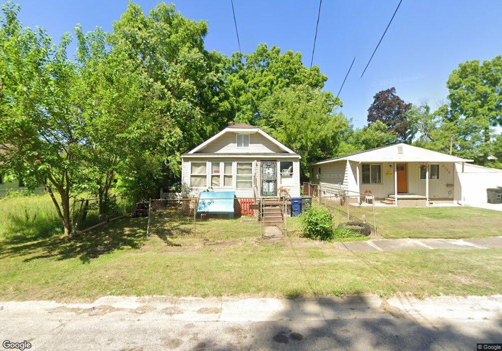
2104 Beach St Flint, MI 48503
Southside Business District NeighborhoodEstimated Value: $27,000 - $48,000
2
Beds
1
Bath
484
Sq Ft
$76/Sq Ft
Est. Value
About This Home
This home is located at 2104 Beach St, Flint, MI 48503 and is currently estimated at $36,756, approximately $75 per square foot. 2104 Beach St is a home located in Genesee County with nearby schools including Freeman Elementary School, Flint Southwestern Classical Academy, and International Academy of Flint (K-12).
Ownership History
Date
Name
Owned For
Owner Type
Purchase Details
Closed on
May 26, 2006
Sold by
Potter Arthur D and Genesee County Land Bank Autho
Bought by
Dawkins Milton and Dawkins Doris
Current Estimated Value
Purchase Details
Closed on
Dec 7, 2004
Sold by
Kildee Daniel T and Genesee County Land Reutilizat
Bought by
Genesee County Land Bank Authority
Purchase Details
Closed on
Sep 9, 2003
Sold by
Kildee Daniel T
Bought by
Genesee County Land Reutilization Counci
Create a Home Valuation Report for This Property
The Home Valuation Report is an in-depth analysis detailing your home's value as well as a comparison with similar homes in the area
Home Values in the Area
Average Home Value in this Area
Purchase History
| Date | Buyer | Sale Price | Title Company |
|---|---|---|---|
| Dawkins Milton | $4,500 | None Available | |
| Genesee County Land Bank Authority | -- | -- | |
| Genesee County Land Reutilization Counci | $628 | -- |
Source: Public Records
Tax History
| Year | Tax Paid | Tax Assessment Tax Assessment Total Assessment is a certain percentage of the fair market value that is determined by local assessors to be the total taxable value of land and additions on the property. | Land | Improvement |
|---|---|---|---|---|
| 2025 | $425 | $8,800 | $0 | $0 |
| 2024 | $409 | $9,500 | $0 | $0 |
| 2023 | $413 | $8,500 | $0 | $0 |
| 2022 | $0 | $6,000 | $0 | $0 |
| 2021 | $411 | $4,700 | $0 | $0 |
| 2020 | $395 | $5,700 | $0 | $0 |
| 2019 | $402 | $4,300 | $0 | $0 |
| 2018 | $376 | $4,200 | $0 | $0 |
| 2017 | $879 | $0 | $0 | $0 |
| 2016 | $346 | $0 | $0 | $0 |
| 2015 | -- | $0 | $0 | $0 |
| 2014 | -- | $0 | $0 | $0 |
| 2012 | -- | $2,500 | $0 | $0 |
Source: Public Records
Map
Nearby Homes
- 636 Partridge St
- 149 E Tobias St
- 517 Morley Ave
- 149 E Linsey Blvd
- 133 E Oakley St
- 1517 Tacoma St
- 420 Pingree Ave
- 1511 Tacoma St
- 2050 Ferris Ave
- 812 Remington Ave
- 2224 Crocker Ave
- 834 Remington Ave
- 741 Barrie Ave
- 1720 Park St
- 2010 Crocker Ave
- 3218 Collingwood Pkwy
- 2221 Howard Ave
- 213 E Lakeview Ave
- 115 E Livingston Dr
- 3214 S Grand Traverse St