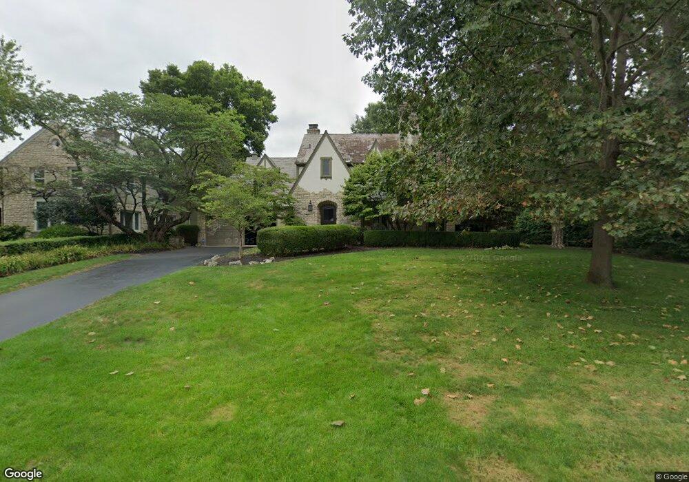
2104 Yorkshire Rd Columbus, OH 43221
Estimated Value: $1,381,000 - $1,697,000
4
Beds
4
Baths
3,431
Sq Ft
$437/Sq Ft
Est. Value
About This Home
This home is located at 2104 Yorkshire Rd, Columbus, OH 43221 and is currently estimated at $1,498,202, approximately $436 per square foot. 2104 Yorkshire Rd is a home located in Franklin County with nearby schools including Barrington Road Elementary School, Jones Middle School, and Upper Arlington High School.
Ownership History
Date
Name
Owned For
Owner Type
Purchase Details
Closed on
May 24, 2017
Sold by
Kulewicz Maryline M and Kulewicz John J
Bought by
Kulewicz John J and Kulewicz Maryline M
Current Estimated Value
Purchase Details
Closed on
Mar 17, 1993
Bought by
Kulewicz Maryline M
Purchase Details
Closed on
Jan 1, 1979
Create a Home Valuation Report for This Property
The Home Valuation Report is an in-depth analysis detailing your home's value as well as a comparison with similar homes in the area
Home Values in the Area
Average Home Value in this Area
Purchase History
| Date | Buyer | Sale Price | Title Company |
|---|---|---|---|
| Kulewicz John J | -- | None Available | |
| Kulewicz Maryline M | $495,000 | -- | |
| -- | $125,000 | -- |
Source: Public Records
Tax History Compared to Growth
Tax History
| Year | Tax Paid | Tax Assessment Tax Assessment Total Assessment is a certain percentage of the fair market value that is determined by local assessors to be the total taxable value of land and additions on the property. | Land | Improvement |
|---|---|---|---|---|
| 2024 | $23,855 | $412,060 | $148,120 | $263,940 |
| 2023 | $23,560 | $412,055 | $148,120 | $263,935 |
| 2022 | $24,152 | $345,630 | $107,730 | $237,900 |
| 2021 | $21,380 | $345,630 | $107,730 | $237,900 |
| 2020 | $21,190 | $345,630 | $107,730 | $237,900 |
| 2019 | $21,139 | $304,850 | $107,730 | $197,120 |
| 2018 | $19,575 | $304,850 | $107,730 | $197,120 |
| 2017 | $19,489 | $304,850 | $107,730 | $197,120 |
| 2016 | $18,000 | $272,240 | $100,630 | $171,610 |
| 2015 | $18,130 | $272,240 | $100,630 | $171,610 |
| 2014 | $18,005 | $272,240 | $100,630 | $171,610 |
| 2013 | $8,670 | $247,485 | $91,490 | $155,995 |
Source: Public Records
Map
Nearby Homes
- 2295 Oxford Rd
- 1932 Suffolk Rd Unit 1932
- 2063 Westover Rd
- 1934 Bedford Rd
- 2276 Northwest Blvd
- 2357 Keep Place Unit 2357
- 2110 Northwest Blvd
- 1631 Roxbury Rd Unit D2
- 1631 Roxbury Rd Unit A1
- 1631 Roxbury Rd Unit B6
- 2015 W 5th Ave Unit 211
- 2015 W 5th Ave Unit 102
- 2015 W 5th Ave Unit 108
- 2593 Coventry Rd
- 1659 Tremont Rd
- 1733 Elmwood Ave
- 1729 Elmwood Ave
- 1565 Berkshire Rd
- 1535 Doone Rd
- 2615 Northwest Blvd
- 2114 Yorkshire Rd
- 2092 Yorkshire Rd
- 2124 Yorkshire Rd
- 2111 Tremont Rd
- 2125 Tremont Rd
- 2095 Tremont Rd
- 2078 Yorkshire Rd
- 2101 Yorkshire Rd
- 2109 Yorkshire Rd
- 2091 Yorkshire Rd
- 2141 Tremont Rd
- 2087 Tremont Rd
- 2121 Yorkshire Rd
- 2074 Yorkshire Rd
- 2145 Tremont Rd
- 2081 Tremont Rd
- 0 Yorkshire Rd
- 2129 Yorkshire Rd
- 2090 Cheshire Rd
- 2080 Cheshire Rd