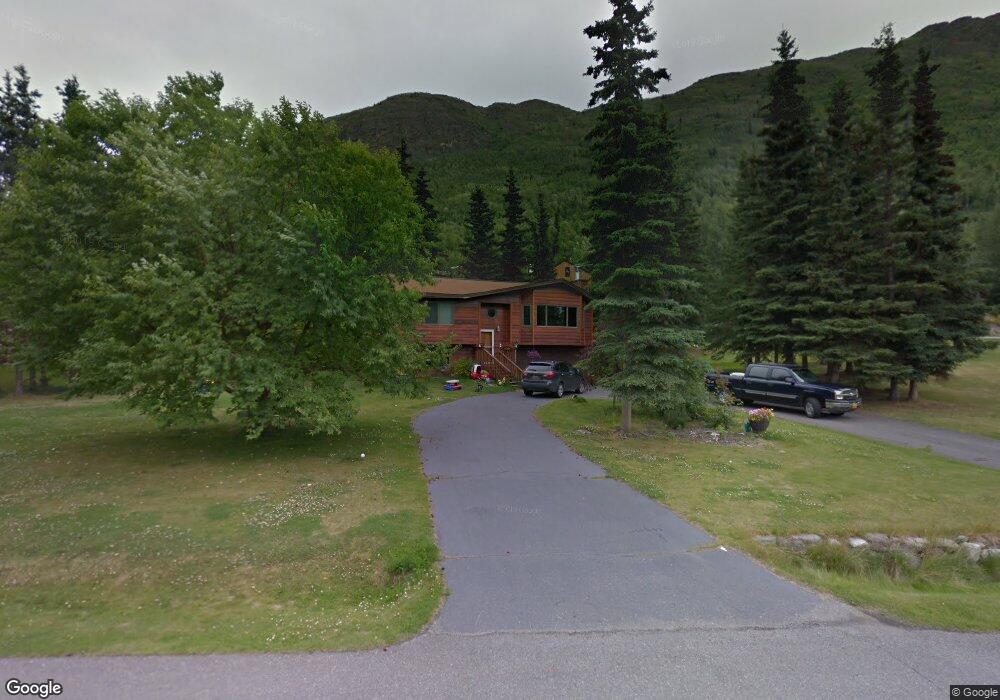
21043 Upper Lowland Ave Eagle River, AK 99577
Eagle River Valley NeighborhoodEstimated Value: $381,000 - $482,960
About This Home
This home is located at 21043 Upper Lowland Ave, Eagle River, AK 99577 and is currently estimated at $434,240, approximately $250 per square foot. 21043 Upper Lowland Ave is a home located in Anchorage Municipality with nearby schools including Ravenwood Elementary School, Gruening Middle School, and Eagle River High School.
Ownership History
We collect this data history from publicly available records. To have your information removed, we recommend requesting removal directly through your county’s website.
Purchase Details
Home Financials for this Owner
Home Financials are based on the most recent Mortgage that was taken out on this home.Purchase Details
Purchase Details
Home Financials for this Owner
Home Financials are based on the most recent Mortgage that was taken out on this home.Home Values in the Area
Average Home Value in this Area
Purchase History
We collect this data history from publicly available records. To have your information removed, we recommend requesting removal directly through your county’s website.
| Date | Buyer | Sale Price | Title Company |
|---|---|---|---|
| -- | Stewart | ||
| -- | -- | ||
| -- | -- |
Mortgage History
We collect this data history from publicly available records. To have your information removed, we recommend requesting removal directly through your county’s website.
| Date | Status | Borrower | Loan Amount |
|---|---|---|---|
| Closed | $245,000 | ||
| Closed | $228,000 | ||
| Closed | $228,000 | ||
| Closed | $81,400 |
Tax History
We collect this data history from publicly available records. To have your information removed, we recommend requesting removal directly through your county’s website.
| Year | Tax Paid | Tax Assessment Tax Assessment Total Assessment is a certain percentage of the fair market value that is determined by local assessors to be the total taxable value of land and additions on the property. | Land | Improvement |
|---|---|---|---|---|
| 2025 | $4,907 | $391,600 | $136,200 | $255,400 |
| 2024 | $4,748 | $372,300 | $120,500 | $251,800 |
| 2023 | $4,777 | $349,400 | $117,000 | $232,400 |
| 2022 | $4,771 | $337,600 | $113,100 | $224,500 |
| 2021 | $5,648 | $319,300 | $113,100 | $206,200 |
| 2020 | $4,131 | $310,800 | $113,100 | $197,700 |
| 2019 | $4,158 | $308,900 | $113,100 | $195,800 |
| 2018 | $3,964 | $296,700 | $105,000 | $191,700 |
| 2017 | $4,463 | $302,100 | $105,000 | $197,100 |
| 2016 | $3,808 | $297,200 | $99,400 | $197,800 |
| 2015 | $3,808 | $290,500 | $100,600 | $189,900 |
| 2014 | $3,808 | $287,500 | $97,300 | $190,200 |
Map
- 10228 Donald Place
- 20607 Lucas Ave
- 10210 Ronald Place
- #1 Mile Hi Way
- 10132 Wren Ln
- 20527 Birch Crest Ln
- 9103 Eagle River Ln
- 19936 1st St
- 20713 Mountain Vista Dr
- 20603 Mountain Vista Dr
- L7 Grey Owl Way
- 20122 Eagles Nest Ct Unit 3A
- L2 Grey Owl Way
- 20730 Mountainside Dr
- 22221 Eagle River Rd
- 19822 First St
- 20485 Icefall Dr
- 20469 Icefall Dr
- 20646 Icefall Dr
- 21040 Trailhead Ave Unit 25
- L3 Upper Lowland Ave
- Lot 3 Upper Lowland Ave
- NHN Upper Lowland Ave
- 21042 Upper Lowland Ave
- 21026 Upper Lowland Ave
- 21125 Lowland Ave
- 10143 Stewart Dr
- 21027 Upper Lowland Ave
- 20976 Upper Lowland Ave
- 21008 Upper Lowland Ave
- 10230 Silvertip Cir
- 21007 Upper Lowland Ave
- L9 B2 Silvertip Cir
- 10050 Stewart Dr
- 10207 Stewart Dr
- 10118 Loon Cir
- 10225 Silvertip Cir
- 21116 Lowland Ave
- 10219 Silvertip Cir
- 21211 Lowland Ave
Ask me questions while you tour the home.