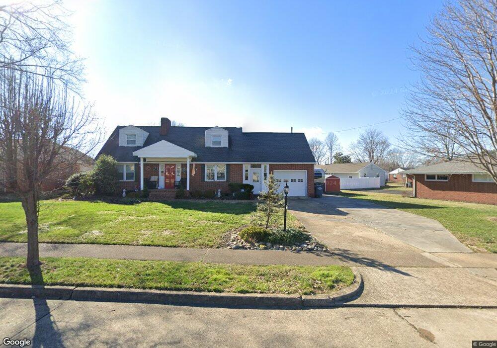
2105 Green Ln Kingsport, TN 37664
Estimated Value: $284,735 - $396,000
4
Beds
2
Baths
1,982
Sq Ft
$173/Sq Ft
Est. Value
About This Home
This home is located at 2105 Green Ln, Kingsport, TN 37664 and is currently estimated at $342,184, approximately $172 per square foot. 2105 Green Ln is a home located in Sullivan County with nearby schools including Andrew Johnson Elementary School, Ross N. Robinson Middle School, and Dobyns-Bennett High School.
Ownership History
Date
Name
Owned For
Owner Type
Purchase Details
Closed on
Dec 12, 2002
Sold by
Andy Singleton and Andy Deborah
Bought by
Hatfield Lois M
Current Estimated Value
Home Financials for this Owner
Home Financials are based on the most recent Mortgage that was taken out on this home.
Original Mortgage
$109,250
Outstanding Balance
$49,829
Interest Rate
5.92%
Estimated Equity
$292,355
Purchase Details
Closed on
Jul 29, 1999
Sold by
Randall Poe David
Bought by
Andy Singleton
Home Financials for this Owner
Home Financials are based on the most recent Mortgage that was taken out on this home.
Original Mortgage
$114,475
Interest Rate
7%
Create a Home Valuation Report for This Property
The Home Valuation Report is an in-depth analysis detailing your home's value as well as a comparison with similar homes in the area
Home Values in the Area
Average Home Value in this Area
Purchase History
| Date | Buyer | Sale Price | Title Company |
|---|---|---|---|
| Hatfield Lois M | $121,702 | -- | |
| Andy Singleton | $120,500 | -- |
Source: Public Records
Mortgage History
| Date | Status | Borrower | Loan Amount |
|---|---|---|---|
| Open | Andy Singleton | $109,250 | |
| Previous Owner | Andy Singleton | $114,475 |
Source: Public Records
Tax History Compared to Growth
Tax History
| Year | Tax Paid | Tax Assessment Tax Assessment Total Assessment is a certain percentage of the fair market value that is determined by local assessors to be the total taxable value of land and additions on the property. | Land | Improvement |
|---|---|---|---|---|
| 2024 | -- | $43,075 | $6,325 | $36,750 |
| 2023 | $1,897 | $43,075 | $6,325 | $36,750 |
| 2022 | $1,897 | $43,075 | $6,325 | $36,750 |
| 2021 | $1,845 | $43,075 | $6,325 | $36,750 |
| 2020 | $1,058 | $43,075 | $6,325 | $36,750 |
| 2019 | $1,907 | $41,150 | $6,325 | $34,825 |
| 2018 | $1,862 | $41,150 | $6,325 | $34,825 |
| 2017 | $1,862 | $41,150 | $6,325 | $34,825 |
| 2016 | $1,864 | $40,125 | $4,600 | $35,525 |
| 2014 | $1,756 | $40,129 | $0 | $0 |
Source: Public Records
Map
Nearby Homes
- 2228 Bruce St
- 2011 Bruce St
- 2136 Cypress St
- 2000 Eastwood Ave
- 1383 Farragut Ave
- Lot 16 Birdwell St
- 2617 Birdwell St
- 1825 Kenwood Rd
- 1449 Warpath Dr
- 1717 Oakwood Dr
- 1657 Redwood Dr
- 1616 Hermitage Dr
- 1604 Hermitage Dr
- 3025 Shipley St
- 2177 Steadman St
- 1433 Miller St
- Lot 17 Ashley St
- Lot 16 Ashley St
- Lot 15 Ashley St
- Lot 14 Ashley St
- 2117 Green Ln
- 2204 Hermitage Dr
- 2101 Green Ln
- 2208 Hermitage Dr
- 2121 Green Ln
- 1280 Konnarock Rd
- 1280 Konnarock Rd
- 1280 Konnarock Rd Unit 1280
- 1280 Konnarock Rd
- 1280 Konnarock Rd
- 1278 Konnarock Rd
- 1276 Konnarock Rd
- 2112 Green Ln
- 2116 Green Ln
- 1274 Konnarock Rd
- 1274 Konnarock Rd
- 2212 Hermitage Dr
- 2108 Green Ln
- 2120 Green Ln
- 2104 Green Ln