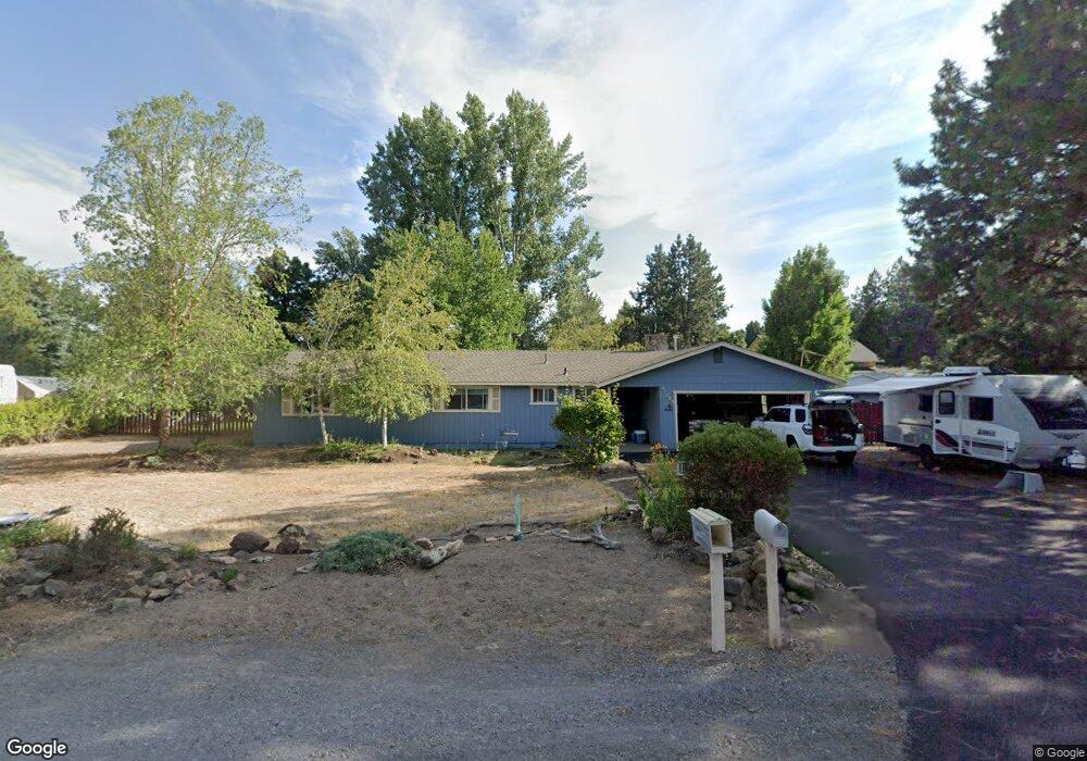
21069 Bayou Dr Bend, OR 97702
Larkspur NeighborhoodEstimated Value: $634,000 - $666,989
3
Beds
2
Baths
1,746
Sq Ft
$374/Sq Ft
Est. Value
About This Home
This home is located at 21069 Bayou Dr, Bend, OR 97702 and is currently estimated at $652,997, approximately $373 per square foot. 21069 Bayou Dr is a home located in Deschutes County with nearby schools including Bear Creek Elementary School, Bend Senior High School, and Eastmont Community School.
Ownership History
Date
Name
Owned For
Owner Type
Purchase Details
Closed on
Feb 27, 2020
Sold by
Williams Michael Leonard and Kulow Kathleen Marie
Bought by
Central Oregon Irrigation District
Current Estimated Value
Purchase Details
Closed on
Mar 12, 2012
Sold by
Williams Michael L and Kulow Kathleen M
Bought by
Williams Michael Leonard and Kulow Kathleen Marie
Create a Home Valuation Report for This Property
The Home Valuation Report is an in-depth analysis detailing your home's value as well as a comparison with similar homes in the area
Home Values in the Area
Average Home Value in this Area
Purchase History
| Date | Buyer | Sale Price | Title Company |
|---|---|---|---|
| Central Oregon Irrigation District | -- | None Available | |
| Williams Michael Leonard | -- | None Available |
Source: Public Records
Tax History Compared to Growth
Tax History
| Year | Tax Paid | Tax Assessment Tax Assessment Total Assessment is a certain percentage of the fair market value that is determined by local assessors to be the total taxable value of land and additions on the property. | Land | Improvement |
|---|---|---|---|---|
| 2025 | $3,933 | $232,750 | -- | -- |
| 2024 | $3,784 | $225,980 | -- | -- |
| 2023 | $3,508 | $219,400 | $0 | $0 |
| 2022 | $3,272 | $206,810 | $0 | $0 |
| 2021 | $3,277 | $200,790 | $0 | $0 |
| 2020 | $3,109 | $200,790 | $0 | $0 |
| 2019 | $3,023 | $194,950 | $0 | $0 |
| 2018 | $2,938 | $189,280 | $0 | $0 |
| 2017 | $2,851 | $183,770 | $0 | $0 |
| 2016 | $2,719 | $178,420 | $0 | $0 |
| 2015 | $2,644 | $173,230 | $0 | $0 |
| 2014 | $2,566 | $168,190 | $0 | $0 |
Source: Public Records
Map
Nearby Homes
- 61730 Joan Ct
- 21035 Clairaway Ave
- 61683 Daly Estates Dr
- 21154 Ritz Place
- 21176 Desert Skies Place
- 21177 Ritz Place
- 61635 Daly Estates Dr Unit 17
- 61807 SE Rolo Ct
- 21116 SE Reed Market Rd
- 21130 SE Reed Market Rd
- 61620 Daly Estates Dr
- 20960 Gardenia Ave
- 61635 Pettigrew Rd Unit 12
- 61839 Avonlea Cir
- 1843 SE Moorwood Ct
- 61839 SE 27th St
- 61847 SE 27th St
- 61536 Ascha Rose Ct
- 61570 SE Rockway Terrace
- 61704 Marigold Ln
- 21081 Bayou Dr
- 21057 Bayou Dr
- 21068 Denning Dr
- 21070 Bayou Dr
- 21058 Denning Dr
- 21078 Denning Dr
- 21060 Bayou Dr
- 21080 Bayou Dr
- 21069 Denning Dr
- 21045 Bayou Dr
- 21091 Bayou Dr
- 21090 Denning Dr
- 21079 Denning Dr
- 21046 Denning Dr
- 21055 Denning Dr
- 21046 Bayou Dr
- 21090 Bayou Dr
- 21057 Clairaway Ave
- 21067 Clairaway Ave
- 21091 Denning Dr