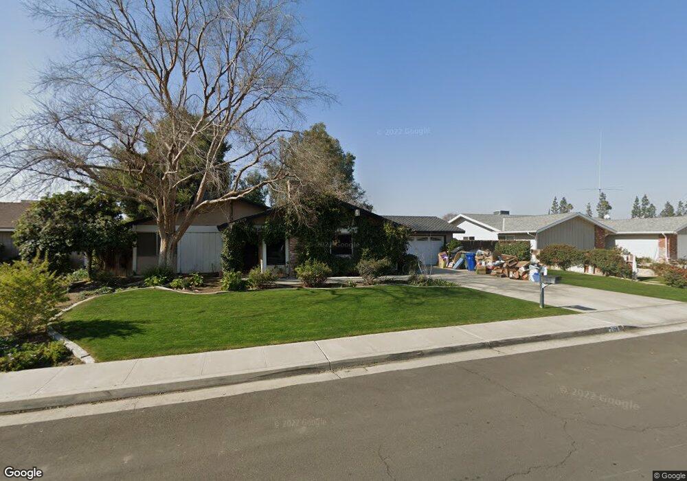
2109 Jason St Bakersfield, CA 93312
Greenacres NeighborhoodEstimated Value: $445,771 - $513,000
3
Beds
2
Baths
1,635
Sq Ft
$286/Sq Ft
Est. Value
About This Home
This home is located at 2109 Jason St, Bakersfield, CA 93312 and is currently estimated at $467,943, approximately $286 per square foot. 2109 Jason St is a home located in Kern County with nearby schools including American Elementary School, Rosedale Middle School, and Liberty High School.
Ownership History
Date
Name
Owned For
Owner Type
Purchase Details
Closed on
Dec 7, 1999
Sold by
Lee Krome Jonathan D and Lee Laura
Bought by
Jensen Keith and Jensen Donna
Current Estimated Value
Home Financials for this Owner
Home Financials are based on the most recent Mortgage that was taken out on this home.
Original Mortgage
$150,895
Outstanding Balance
$47,130
Interest Rate
7.83%
Mortgage Type
VA
Estimated Equity
$420,813
Create a Home Valuation Report for This Property
The Home Valuation Report is an in-depth analysis detailing your home's value as well as a comparison with similar homes in the area
Home Values in the Area
Average Home Value in this Area
Purchase History
| Date | Buyer | Sale Price | Title Company |
|---|---|---|---|
| Jensen Keith | $146,500 | Fidelity National Title Co |
Source: Public Records
Mortgage History
| Date | Status | Borrower | Loan Amount |
|---|---|---|---|
| Open | Jensen Keith | $150,895 |
Source: Public Records
Tax History Compared to Growth
Tax History
| Year | Tax Paid | Tax Assessment Tax Assessment Total Assessment is a certain percentage of the fair market value that is determined by local assessors to be the total taxable value of land and additions on the property. | Land | Improvement |
|---|---|---|---|---|
| 2025 | $3,040 | $225,141 | $69,151 | $155,990 |
| 2024 | $2,955 | $220,728 | $67,796 | $152,932 |
| 2023 | $2,955 | $216,401 | $66,467 | $149,934 |
| 2022 | $2,870 | $212,159 | $65,164 | $146,995 |
| 2021 | $2,757 | $208,000 | $63,887 | $144,113 |
| 2020 | $2,688 | $205,868 | $63,232 | $142,636 |
| 2019 | $2,633 | $205,868 | $63,232 | $142,636 |
| 2018 | $2,557 | $197,877 | $60,778 | $137,099 |
| 2017 | $2,508 | $193,998 | $59,587 | $134,411 |
| 2016 | $2,362 | $190,195 | $58,419 | $131,776 |
| 2015 | $2,322 | $187,339 | $57,542 | $129,797 |
| 2014 | $2,247 | $183,670 | $56,415 | $127,255 |
Source: Public Records
Map
Nearby Homes
- 2105 Jason St
- 2008 Torrey Dr
- 2125 Verdugo Ln
- 11520 Pinehaven Ave
- 10920 Cilantro Ave
- 11510 Finsbury Ct
- 3301 Beyers St
- 10512 Dee Ave
- 11705 Cactus Dr
- 3105 Silver Spur Way
- 3122 Campfire Dr Unit 2
- 3416 Aslin St
- 3435 Moss St
- 10514 Brimhall Rd
- 10701 Meacham Rd
- 1110 Coyote Springs Dr
- 12204 Connery Way
- 10418 Brimhall Rd
- 2217 Calloway Dr
- 11908 Nebula Ct