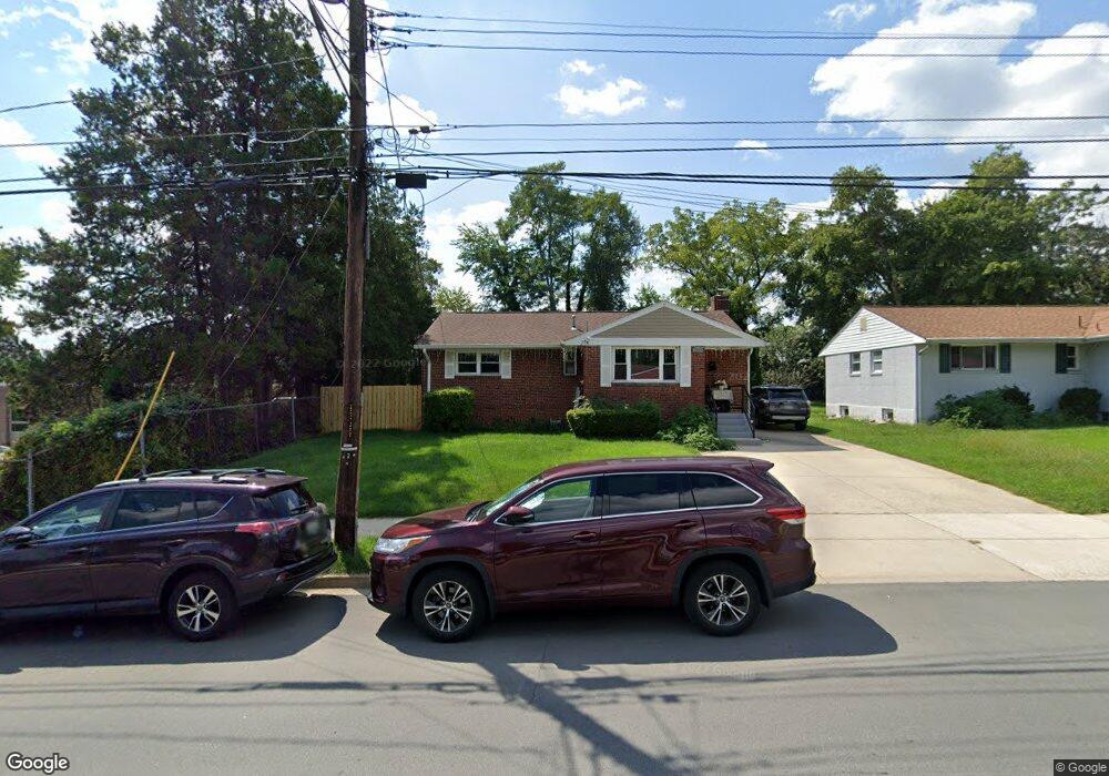
2109 Lewis Ave Rockville, MD 20851
East Rockville NeighborhoodEstimated Value: $389,919 - $520,000
--
Bed
1
Bath
1,020
Sq Ft
$461/Sq Ft
Est. Value
About This Home
This home is located at 2109 Lewis Ave, Rockville, MD 20851 and is currently estimated at $470,230, approximately $461 per square foot. 2109 Lewis Ave is a home located in Montgomery County with nearby schools including Twinbrook Elementary School, Julius West Middle School, and Richard Montgomery High School.
Ownership History
Date
Name
Owned For
Owner Type
Purchase Details
Closed on
Oct 25, 2019
Sold by
Andino Jose E and Andino Jose A
Bought by
Hernandez Santos A Andino
Current Estimated Value
Home Financials for this Owner
Home Financials are based on the most recent Mortgage that was taken out on this home.
Original Mortgage
$245,000
Outstanding Balance
$159,493
Interest Rate
3.6%
Mortgage Type
New Conventional
Estimated Equity
$310,737
Purchase Details
Closed on
Aug 12, 1993
Sold by
Robert and Kraft M
Bought by
Andino Jose E
Create a Home Valuation Report for This Property
The Home Valuation Report is an in-depth analysis detailing your home's value as well as a comparison with similar homes in the area
Home Values in the Area
Average Home Value in this Area
Purchase History
| Date | Buyer | Sale Price | Title Company |
|---|---|---|---|
| Hernandez Santos A Andino | -- | Boston National Ttl Agcy Llc | |
| Andino Jose E | $148,000 | -- |
Source: Public Records
Mortgage History
| Date | Status | Borrower | Loan Amount |
|---|---|---|---|
| Open | Hernandez Santos A Andino | $245,000 |
Source: Public Records
Tax History Compared to Growth
Tax History
| Year | Tax Paid | Tax Assessment Tax Assessment Total Assessment is a certain percentage of the fair market value that is determined by local assessors to be the total taxable value of land and additions on the property. | Land | Improvement |
|---|---|---|---|---|
| 2025 | $4,843 | $323,667 | -- | -- |
| 2024 | $4,843 | $309,733 | $0 | $0 |
| 2023 | $5,285 | $295,800 | $170,000 | $125,800 |
| 2022 | $3,643 | $285,200 | $0 | $0 |
| 2021 | $3,494 | $274,600 | $0 | $0 |
| 2020 | $3,326 | $264,000 | $161,900 | $102,100 |
| 2019 | $3,286 | $260,867 | $0 | $0 |
| 2018 | $3,268 | $257,733 | $0 | $0 |
| 2017 | $3,853 | $254,600 | $0 | $0 |
| 2016 | -- | $242,967 | $0 | $0 |
| 2015 | $2,735 | $231,333 | $0 | $0 |
| 2014 | $2,735 | $219,700 | $0 | $0 |
Source: Public Records
Map
Nearby Homes
- 2012 Henry Rd
- 1910 Lewis Ave
- 13113 Ardennes Ave
- 1204 Parrish Dr
- 5724 Denfield Rd
- 1924 Chapman Ave Unit 10
- 864 Thompson Crescent Unit 44
- 160 Talbott St
- 13209 Ardennes Ave
- 199 Talbott St
- 135 Talbott St
- 5714 Crawford Dr
- 1618 Martha Terrace
- 6050 California Cir Unit 108
- 5750 Bou Ave Unit 816
- 5750 Bou Ave Unit 1111
- 5750 Bou Ave Unit 1106
- 5750 Bou Ave Unit 712
- 1510 Broadwood Dr
- 1306 Abbott Rd
- 2107 Lewis Ave
- 2211 Lewis Ave
- 2105 Lewis Ave
- 2103 Lewis Ave
- 2112 Lewis Ave
- 2108 Lewis Ave
- 2106 Lewis Ave
- 2114 Lewis Ave
- 2104 Lewis Ave
- 2101 Lewis Ave
- 2102 Lewis Ave
- 2118 Lewis Ave
- 2116 Lewis Ave
- 1101 Brooke Dr
- 2209 Stanley Ave
- 2207 Stanley Ave
- 2120 Lewis Ave
- 2305 Rockland Ave
- 2205 Stanley Ave
- 2211 Stanley Ave