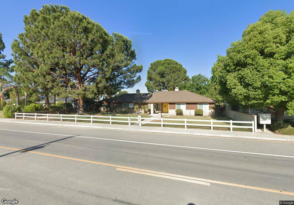
2109 Renfro Rd Bakersfield, CA 93314
Estimated Value: $587,000 - $620,000
4
Beds
--
Bath
2,204
Sq Ft
$273/Sq Ft
Est. Value
About This Home
This home is located at 2109 Renfro Rd, Bakersfield, CA 93314 and is currently estimated at $602,589, approximately $273 per square foot. 2109 Renfro Rd is a home located in Kern County with nearby schools including Centennial Elementary School, Rosedale Middle School, and Liberty High School.
Ownership History
Date
Name
Owned For
Owner Type
Purchase Details
Closed on
Jun 7, 2023
Sold by
Patterson Family Trust
Bought by
Pounds Julie Ann and Pounds Dennis Reed
Current Estimated Value
Home Financials for this Owner
Home Financials are based on the most recent Mortgage that was taken out on this home.
Original Mortgage
$273,000
Outstanding Balance
$265,700
Interest Rate
6.39%
Mortgage Type
New Conventional
Estimated Equity
$336,889
Purchase Details
Closed on
Jul 31, 2002
Sold by
Patterson Mark David and Patterson Barbara J
Bought by
Patterson Mark David and Patterson Barbara Jeane
Create a Home Valuation Report for This Property
The Home Valuation Report is an in-depth analysis detailing your home's value as well as a comparison with similar homes in the area
Home Values in the Area
Average Home Value in this Area
Purchase History
| Date | Buyer | Sale Price | Title Company |
|---|---|---|---|
| Pounds Julie Ann | $425,000 | Ticor Title Company | |
| Patterson Mark David | -- | -- |
Source: Public Records
Mortgage History
| Date | Status | Borrower | Loan Amount |
|---|---|---|---|
| Open | Pounds Julie Ann | $273,000 |
Source: Public Records
Tax History Compared to Growth
Tax History
| Year | Tax Paid | Tax Assessment Tax Assessment Total Assessment is a certain percentage of the fair market value that is determined by local assessors to be the total taxable value of land and additions on the property. | Land | Improvement |
|---|---|---|---|---|
| 2025 | $6,574 | $550,371 | $156,060 | $394,311 |
| 2024 | $3,877 | $539,580 | $153,000 | $386,580 |
| 2023 | $3,877 | $297,417 | $76,472 | $220,945 |
| 2022 | $3,782 | $291,586 | $74,973 | $216,613 |
| 2021 | $3,659 | $285,869 | $73,503 | $212,366 |
| 2020 | $3,582 | $282,939 | $72,750 | $210,189 |
| 2019 | $3,513 | $282,939 | $72,750 | $210,189 |
| 2018 | $3,416 | $271,954 | $69,926 | $202,028 |
| 2017 | $3,355 | $266,622 | $68,555 | $198,067 |
| 2016 | $3,155 | $261,395 | $67,211 | $194,184 |
| 2015 | $3,104 | $257,470 | $66,202 | $191,268 |
| 2014 | $3,033 | $252,428 | $64,906 | $187,522 |
Source: Public Records
Map
Nearby Homes
- 14508 Harvest Crest Ave
- 1838 Renfro Rd
- 1801 Blossom Crest St
- 1732 Blossom Crest St
- 14804 Henderson Ave
- 14942 Championship Way
- 14912 Henderson Ave
- 15027 Henderson Ave
- 15042 Championship Way
- Plan 2029 at Northpoint
- Plan 2281 at Northpoint
- Plan 2141 at Northpoint
- Plan 1698 at Northpoint
- Plan 2998 at Northpoint
- Plan 2659 at Northpoint
- Plan 2038 at Northpoint
- 14035 Rosedale Hwy Unit 72
- 14035 Rosedale Hwy Unit 82
- 14035 Rosedale Hwy Unit 87
- 14035 Rosedale Hwy Unit 69