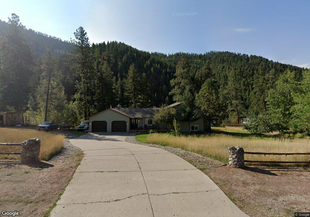
21091 Handley Loop Clinton, MT 59825
Clinton NeighborhoodEstimated Value: $474,000 - $565,000
3
Beds
2
Baths
1,344
Sq Ft
$395/Sq Ft
Est. Value
About This Home
This home is located at 21091 Handley Loop, Clinton, MT 59825 and is currently estimated at $531,348, approximately $395 per square foot. 21091 Handley Loop is a home located in Missoula County with nearby schools including Clinton Elementary School and Sentinel High School.
Ownership History
Date
Name
Owned For
Owner Type
Purchase Details
Closed on
Jun 6, 2002
Sold by
Clark Brian A and Acevedo Clark Kristina S
Bought by
Nilson Robert H and Lewandowski Juli J
Current Estimated Value
Home Financials for this Owner
Home Financials are based on the most recent Mortgage that was taken out on this home.
Original Mortgage
$131,000
Outstanding Balance
$55,468
Interest Rate
6.83%
Estimated Equity
$475,880
Create a Home Valuation Report for This Property
The Home Valuation Report is an in-depth analysis detailing your home's value as well as a comparison with similar homes in the area
Home Values in the Area
Average Home Value in this Area
Purchase History
| Date | Buyer | Sale Price | Title Company |
|---|---|---|---|
| Nilson Robert H | -- | -- |
Source: Public Records
Mortgage History
| Date | Status | Borrower | Loan Amount |
|---|---|---|---|
| Open | Nilson Robert H | $131,000 |
Source: Public Records
Tax History
| Year | Tax Paid | Tax Assessment Tax Assessment Total Assessment is a certain percentage of the fair market value that is determined by local assessors to be the total taxable value of land and additions on the property. | Land | Improvement |
|---|---|---|---|---|
| 2025 | $3,860 | $539,300 | $136,600 | $402,700 |
| 2024 | $4,424 | $456,800 | $91,600 | $365,200 |
| 2023 | $3,790 | $456,800 | $91,600 | $365,200 |
| 2022 | $3,049 | $304,200 | $0 | $0 |
| 2021 | $2,974 | $304,200 | $0 | $0 |
| 2020 | $2,808 | $277,200 | $0 | $0 |
| 2019 | $2,794 | $277,200 | $0 | $0 |
| 2018 | $2,538 | $263,900 | $0 | $0 |
| 2017 | $2,328 | $263,900 | $0 | $0 |
| 2016 | $2,190 | $237,100 | $0 | $0 |
| 2015 | $2,044 | $237,100 | $0 | $0 |
| 2014 | $2,110 | $137,270 | $0 | $0 |
Source: Public Records
Map
Nearby Homes
- 22225 Wallace Creek Rd
- NHN Stitt St
- 11055 Silver St
- Lot 13 Pamin Loop
- 21082 Pamin Loop
- Nhn Us Highway 10 E
- 25575 Patter Spur Rd S
- 17755 E Mullan Rd
- Lot 15 Muddler Ct
- Lot 17 Caddisfly Ct
- Lot 16 Stonefly Rd
- Lot 11 Stonefly Rd
- Lot 9 Stonefly Rd
- Lot 12 Stonefly Rd
- 24570 Stonefly Rd
- Lot 2 Caddisfly Ct
- 14297 Caddisfly Ct
- Nhn Bonita Ranger Station Rd
- 27235 Lazy Springs Rd
- 14200 Turah Rd
- 21077 Handley Loop
- 21084 Handley Loop
- 21105 Handley Loop
- 21132 Handley Loop
- 21643 Wallace Creek Rd
- 21133 Handley Loop
- 21063 Handley Loop
- 21070 Handley Loop
- 21119 Handley Loop
- 21621 Wallace Creek Rd
- 21147 Handley Loop
- 21054 Handley Loop
- 21049 Handley Loop
- 21505 Wallace Creek Rd
- 21909 Wallace Creek Rd
- 21030 Handley Loop
- 21475 Wallace Creek Rd
- 9620 Bridge Burn Trail
- 21035 Handley Loop
- 21850 Bridge Burn Trail
Your Personal Tour Guide
Ask me questions while you tour the home.