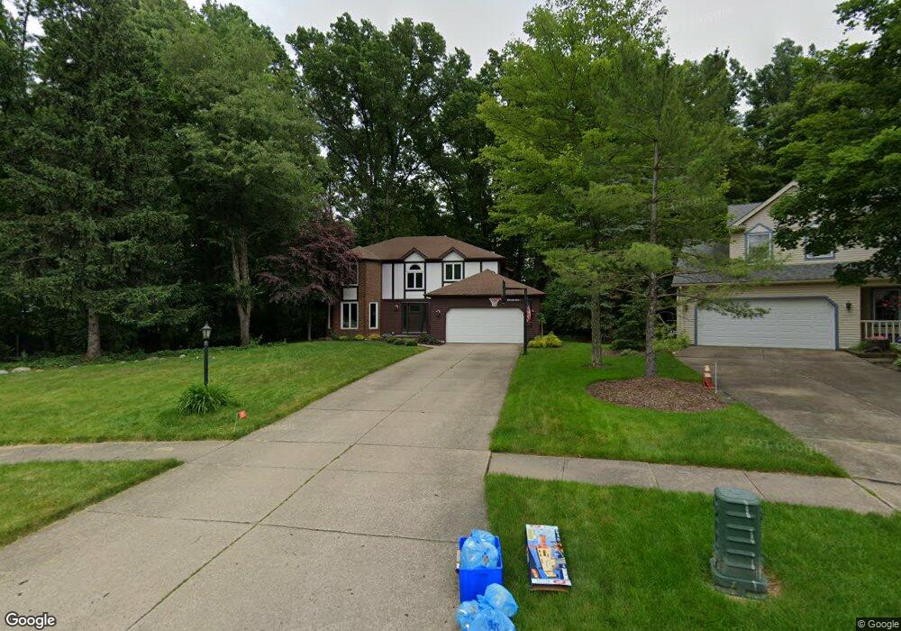
21092 Montclare Blvd Strongsville, OH 44149
Estimated Value: $415,000 - $443,000
4
Beds
3
Baths
2,409
Sq Ft
$178/Sq Ft
Est. Value
About This Home
This home is located at 21092 Montclare Blvd, Strongsville, OH 44149 and is currently estimated at $429,964, approximately $178 per square foot. 21092 Montclare Blvd is a home located in Cuyahoga County with nearby schools including Strongsville High School, St Mary School, and Sts Joseph & John Interparochial School.
Ownership History
Date
Name
Owned For
Owner Type
Purchase Details
Closed on
Sep 30, 2005
Sold by
Youngstein Oren D and Youngstein Marian A
Bought by
Isham Shawn W and Isham Lisa M
Current Estimated Value
Home Financials for this Owner
Home Financials are based on the most recent Mortgage that was taken out on this home.
Original Mortgage
$190,000
Outstanding Balance
$102,145
Interest Rate
5.83%
Mortgage Type
Fannie Mae Freddie Mac
Estimated Equity
$327,819
Purchase Details
Closed on
Jul 26, 1996
Sold by
Docherty William J
Bought by
Youngstein Oren D
Purchase Details
Closed on
Apr 15, 1986
Bought by
Docherty Willialm J
Purchase Details
Closed on
Dec 11, 1985
Bought by
Stonecrest Homes Inc
Purchase Details
Closed on
Jan 1, 1985
Bought by
Fair Farms Co
Create a Home Valuation Report for This Property
The Home Valuation Report is an in-depth analysis detailing your home's value as well as a comparison with similar homes in the area
Home Values in the Area
Average Home Value in this Area
Purchase History
| Date | Buyer | Sale Price | Title Company |
|---|---|---|---|
| Isham Shawn W | $237,500 | Signature Title | |
| Youngstein Oren D | $199,000 | -- | |
| Docherty Willialm J | $135,000 | -- | |
| Stonecrest Homes Inc | $26,000 | -- | |
| Fair Farms Co | -- | -- |
Source: Public Records
Mortgage History
| Date | Status | Borrower | Loan Amount |
|---|---|---|---|
| Open | Isham Shawn W | $190,000 |
Source: Public Records
Tax History Compared to Growth
Tax History
| Year | Tax Paid | Tax Assessment Tax Assessment Total Assessment is a certain percentage of the fair market value that is determined by local assessors to be the total taxable value of land and additions on the property. | Land | Improvement |
|---|---|---|---|---|
| 2024 | $5,944 | $126,595 | $23,625 | $102,970 |
| 2023 | $6,169 | $98,530 | $23,280 | $75,250 |
| 2022 | $6,125 | $98,530 | $23,280 | $75,250 |
| 2021 | $6,076 | $98,530 | $23,280 | $75,250 |
| 2020 | $6,024 | $86,420 | $20,410 | $66,010 |
| 2019 | $5,848 | $246,900 | $58,300 | $188,600 |
| 2018 | $5,307 | $86,420 | $20,410 | $66,010 |
| 2017 | $5,350 | $80,640 | $18,410 | $62,230 |
| 2016 | $5,306 | $80,640 | $18,410 | $62,230 |
| 2015 | $5,225 | $80,640 | $18,410 | $62,230 |
| 2014 | $5,225 | $78,300 | $17,890 | $60,410 |
Source: Public Records
Map
Nearby Homes
- 8627 Courtland Dr
- 84 Sprague Rd
- 8036 Fair Rd
- 8902 Lincolnshire Blvd
- 104 Whitehall Dr
- 740 Fair St
- 9401 Pheasant Run Place
- 9829 Plum Brook Ln
- 243 Jananna Dr
- 10353 Oak Branch Trail
- 9598 Pebble Brook Ln
- 0 Priem Rd
- 22300 Rock Creek Cir
- 148 Meadow Cir
- 8746 Barton Dr
- 21355 Hickory Branch Trail
- 21176 Hickory Branch Trail
- 458 Sprague Rd
- 20424 Scotch Pine Way
- 10839 Prospect Rd
- 21140 Montclare Blvd
- 21044 Montclare Blvd
- 20996 Montclare Blvd
- 21188 Montclare Blvd
- 21059 Montclare Blvd
- 20948 Montclare Blvd
- 21236 Montclare Blvd
- 20987 Montclare Blvd
- 20935 Montclare Blvd
- 21284 Montclare Blvd
- 21190 Jonathan Dr
- 8628 Fair Rd
- 21242 Jonathan Dr
- 21138 Jonathan Dr
- 21292 Jonathan Dr
- 8676 Fair Rd
- 21086 Jonathan Dr
- 21481 Montclare Blvd
- 8714 Fair Rd
- 8586 Fair Rd