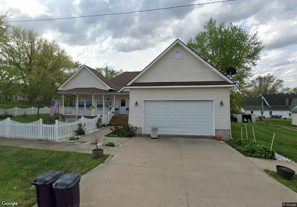
211 E 2nd St Dearborn, MO 64439
Estimated Value: $221,000 - $430,000
3
Beds
2
Baths
1,797
Sq Ft
$168/Sq Ft
Est. Value
About This Home
This home is located at 211 E 2nd St, Dearborn, MO 64439 and is currently estimated at $302,590, approximately $168 per square foot. 211 E 2nd St is a home located in Platte County with nearby schools including North Platte Elementary School, North Platte Intermediate School, and North Platte Junior High School.
Ownership History
Date
Name
Owned For
Owner Type
Purchase Details
Closed on
Jan 18, 2021
Sold by
Shove Christopher
Bought by
Shove Christopher and Shove Ilona
Current Estimated Value
Purchase Details
Closed on
Dec 22, 2008
Sold by
Dowing David A and Dowing Rose M
Bought by
Shove Christopher
Home Financials for this Owner
Home Financials are based on the most recent Mortgage that was taken out on this home.
Original Mortgage
$103,240
Interest Rate
6.19%
Mortgage Type
Future Advance Clause Open End Mortgage
Purchase Details
Closed on
Jun 15, 2005
Sold by
Sellars Steve and Sellars Deborah A
Bought by
Shove Christopher
Home Financials for this Owner
Home Financials are based on the most recent Mortgage that was taken out on this home.
Original Mortgage
$199,369
Interest Rate
5.78%
Mortgage Type
VA
Create a Home Valuation Report for This Property
The Home Valuation Report is an in-depth analysis detailing your home's value as well as a comparison with similar homes in the area
Purchase History
| Date | Buyer | Sale Price | Title Company |
|---|---|---|---|
| Shove Christopher | -- | None Available | |
| Shove Christopher | -- | Platte County Title And Abst | |
| Shove Christopher | -- | Platte Cnty Title & Abstract |
Source: Public Records
Mortgage History
| Date | Status | Borrower | Loan Amount |
|---|---|---|---|
| Closed | Shove Christopher | $103,240 | |
| Previous Owner | Shove Christopher | $199,369 |
Source: Public Records
Tax History
| Year | Tax Paid | Tax Assessment Tax Assessment Total Assessment is a certain percentage of the fair market value that is determined by local assessors to be the total taxable value of land and additions on the property. | Land | Improvement |
|---|---|---|---|---|
| 2025 | $3,055 | $41,346 | $2,699 | $38,647 |
| 2024 | $2,929 | $41,346 | $2,699 | $38,647 |
| 2023 | $2,929 | $41,346 | $2,699 | $38,647 |
| 2022 | $2,737 | $38,283 | $2,699 | $35,584 |
| 2021 | $2,746 | $38,283 | $2,699 | $35,584 |
| 2020 | $2,685 | $36,841 | $3,666 | $33,175 |
| 2019 | $2,685 | $36,841 | $3,666 | $33,175 |
| 2018 | $2,530 | $34,480 | $2,850 | $31,630 |
| 2017 | $2,530 | $34,480 | $2,850 | $31,630 |
| 2016 | $2,356 | $32,300 | $2,850 | $29,450 |
| 2015 | $2,356 | $32,300 | $2,850 | $29,450 |
| 2013 | $2,849 | $32,300 | $0 | $0 |
Source: Public Records
Map
Nearby Homes
- 601 Main St
- 24110 Highway Y N A
- 103 Johnson Cir
- 107 Johnson Cir
- 109 Johnson Cir
- 108 Johnson Cir
- 7693 SE Benner Lake Rd
- 17391 SE State Route 371
- 21970 Lamar Rd
- 18200 SE 14th Rd
- 1261 SE Mill St
- 207 2nd St E
- 19710 Kansas City Blvd
- U Highway
- 0 U Hwy Unit HMS2588353
- 0 S East 95th Rd
- 20860 County Road P
- 19255 Lane Tree Dr
- 0001 Edgerton Junction Rd
- 0000 Edgerton Junction Rd
Your Personal Tour Guide
Ask me questions while you tour the home.