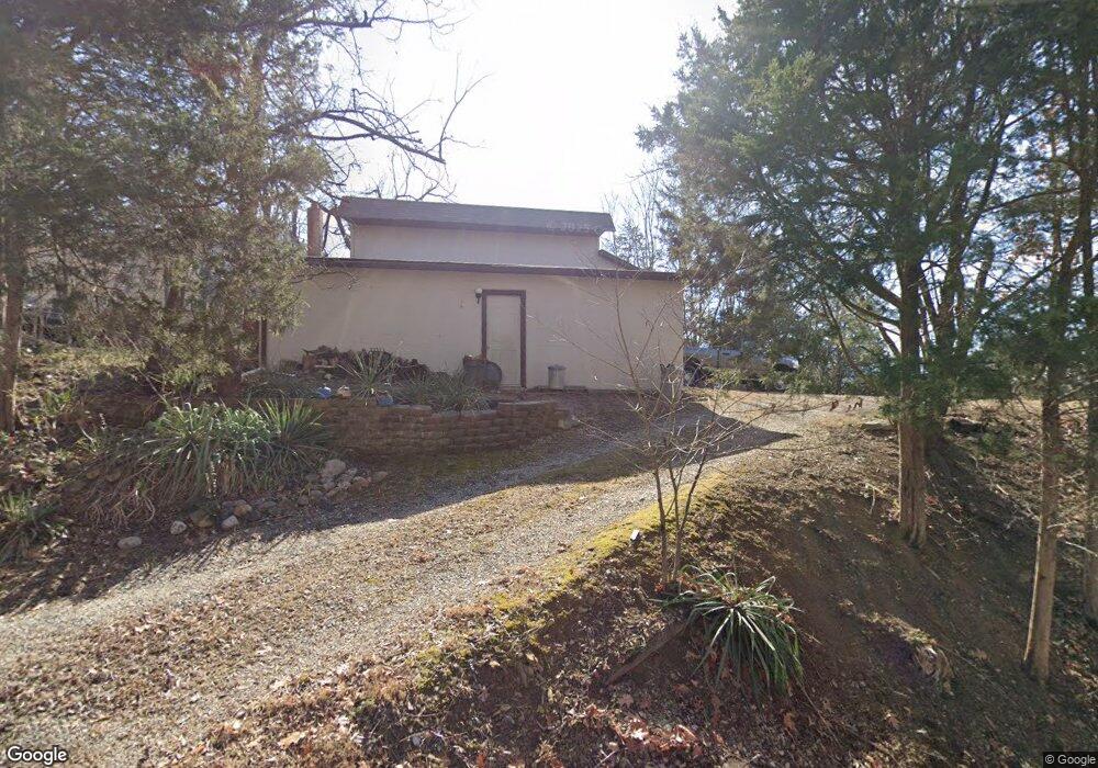
211 Point Ln Dandridge, TN 37725
Estimated Value: $382,000 - $598,000
--
Bed
5
Baths
552
Sq Ft
$919/Sq Ft
Est. Value
About This Home
This home is located at 211 Point Ln, Dandridge, TN 37725 and is currently estimated at $507,055, approximately $918 per square foot. 211 Point Ln is a home located in Jefferson County.
Ownership History
Date
Name
Owned For
Owner Type
Purchase Details
Closed on
Jul 7, 1994
Sold by
Dale Dunleavy
Bought by
Vaughn Leslie
Current Estimated Value
Purchase Details
Closed on
Jun 30, 1994
Bought by
Leslie Vaughn and Leslie Margaret E
Purchase Details
Closed on
Jul 22, 1987
Bought by
Dunlevey Dale E and Dunlevey Norma J
Purchase Details
Closed on
Apr 16, 1984
Bought by
Gary Robert
Purchase Details
Closed on
Jul 10, 1974
Create a Home Valuation Report for This Property
The Home Valuation Report is an in-depth analysis detailing your home's value as well as a comparison with similar homes in the area
Home Values in the Area
Average Home Value in this Area
Purchase History
| Date | Buyer | Sale Price | Title Company |
|---|---|---|---|
| Vaughn Leslie | -- | -- | |
| Leslie Vaughn | $38,500 | -- | |
| Dunlevey Dale E | $40,000 | -- | |
| Gary Robert | -- | -- | |
| -- | -- | -- |
Source: Public Records
Tax History Compared to Growth
Tax History
| Year | Tax Paid | Tax Assessment Tax Assessment Total Assessment is a certain percentage of the fair market value that is determined by local assessors to be the total taxable value of land and additions on the property. | Land | Improvement |
|---|---|---|---|---|
| 2025 | $1,491 | $104,275 | $75,000 | $29,275 |
| 2023 | $1,256 | $54,600 | $0 | $0 |
| 2022 | $1,196 | $54,600 | $36,575 | $18,025 |
| 2021 | $1,196 | $54,600 | $36,575 | $18,025 |
| 2020 | $1,196 | $54,600 | $36,575 | $18,025 |
| 2019 | $1,196 | $54,600 | $36,575 | $18,025 |
| 2018 | $1,026 | $43,650 | $26,250 | $17,400 |
| 2017 | $1,026 | $43,650 | $26,250 | $17,400 |
| 2016 | $1,026 | $43,650 | $26,250 | $17,400 |
| 2015 | $1,026 | $43,650 | $26,250 | $17,400 |
| 2014 | $1,026 | $43,650 | $26,250 | $17,400 |
Source: Public Records
Map
Nearby Homes
- 1928 Bouldercrest Dr
- 1991 Lakebrook Cir
- 1988 Lakebrook Cir
- 136 Crosslake Ln
- 417 Little Cove Dr
- 1045 Southwind Cir
- 1887 Lakebrook Cir
- 1806 Pheasant Crossing Dr
- 1018 Southwind Cir
- 1710 Ferry Hill Rd
- Lots 1&2 Ferry Hill Rd
- 1614 Sams Dr
- 1635 Sams Dr
- 344 Economy Cir
- 312 Economy Cir
- 1920 Mountain Lake Dr
- 539 Morie Rd
- 428 River Bend Dr
- 323 Eagle Claw Ln
- 450 Riverbend Dr
- 207 Point Ln
- 219 Point Ln
- 201 Lakepoint Ln
- 5075 Elm Brook Rd
- 5071 Elm Brook Rd
- 5067 Elm Brook Rd
- 447 Barry Cove
- 423 Barry Cove
- 5048 Elm Brook Rd
- 5044 Elm Brook Rd
- 5040 Elm Brook Rd
- 5036 Elm Brook Rd
- 5063 Elm Brook Rd
- 5059 Elm Brook Rd
- 5055 Elm Brook Rd
- 5043 Elm Brook Rd
- 6033 Sycamore Stream Rd
- 6029 Sycamore Stream Rd
- 5039 Elm Brook Rd
- 6025 Sycamore Stream Rd