


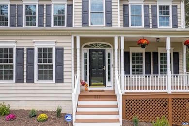
211 Red Cedar Rd Barboursville, VA 22923
Estimated payment $3,201/month
Highlights
- Vaulted Ceiling
- Side Porch
- Entrance Foyer
- Breakfast Area or Nook
- Walk-In Closet
- Central Air
About This Home
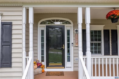
++ OPEN HOUSE SAT 10/18 1:00-3:00 ++ Come see this recently updated, one owner home in Preddy Creek, a great location close to everything on 29, but in a quiet and peaceful community. This house sits on a large, partially cleared 1.62 acre lot!! Exterior improvements and updates include new roof with warranty and gutter guards, new windows with warranty, new Trex decking front and back, and landscaping. Interior upgrades and improvements include new flooring, quartz countertops, refreshed bathrooms, new paint throughout. The major systems are top of the line like HVAC, Water Heater, Kitchen appliances and upstairs washer and dryer. The large walk out basement is conditioned, plumbed and ready to be finished, should you choose. This is a great house in a great location that won't last long! Come see it today!
Home Details
Home Type
- Single Family
Est. Annual Taxes
- $3,049
Year Built
- Built in 2003
Lot Details
- 1.62 Acre Lot
- Zoning described as R-1 Single Family Residential
Parking
- 2 Car Garage
- Basement Garage
- Side Facing Garage
- Garage Door Opener
Home Design
- Poured Concrete
- Stick Built Home
Interior Spaces
- 2-Story Property
- Vaulted Ceiling
- Entrance Foyer
- Basement
Kitchen
- Breakfast Area or Nook
- Eat-In Kitchen
- Microwave
- Dishwasher
Bedrooms and Bathrooms
- 4 Bedrooms
- Walk-In Closet
Outdoor Features
- Side Porch
Schools
- Ruckersville Elementary School
- William Monroe Middle School
- William Monroe High School
Utilities
- Central Air
- Heat Pump System
Community Details
- Preddy Creek Subdivision
Listing and Financial Details
- Assessor Parcel Number 66F 13 103
Map
Home Values in the Area
Average Home Value in this Area
Tax History
| Year | Tax Paid | Tax Assessment Tax Assessment Total Assessment is a certain percentage of the fair market value that is determined by local assessors to be the total taxable value of land and additions on the property. | Land | Improvement |
|---|---|---|---|---|
| 2025 | $3,048 | $441,800 | $70,000 | $371,800 |
| 2024 | $2,916 | $410,700 | $70,000 | $340,700 |
| 2023 | $2,998 | $410,700 | $70,000 | $340,700 |
| 2022 | $2,671 | $325,700 | $70,000 | $255,700 |
| 2021 | $2,671 | $325,700 | $70,000 | $255,700 |
| 2020 | $2,598 | $316,800 | $70,000 | $246,800 |
| 2019 | $2,598 | $316,800 | $70,000 | $246,800 |
| 2018 | $2,385 | $307,700 | $70,000 | $237,700 |
| 2017 | $2,385 | $307,700 | $70,000 | $237,700 |
| 2016 | $2,265 | $292,200 | $70,000 | $222,200 |
| 2015 | $2,192 | $292,200 | $70,000 | $222,200 |
| 2014 | $2,104 | $292,200 | $70,000 | $222,200 |
| 2013 | -- | $292,200 | $70,000 | $222,200 |
Property History
| Date | Event | Price | List to Sale | Price per Sq Ft |
|---|---|---|---|---|
| 09/20/2025 09/20/25 | For Sale | $559,000 | -- | $223 / Sq Ft |
Purchase History
| Date | Type | Sale Price | Title Company |
|---|---|---|---|
| Bargain Sale Deed | $420,725 | Old Republic National Title In | |
| Bargain Sale Deed | $333,000 | Old Republic National Title In | |
| Gift Deed | -- | None Available |
Mortgage History
| Date | Status | Loan Amount | Loan Type |
|---|---|---|---|
| Open | $389,000 | Credit Line Revolving |
Source: Charlottesville area Association of Realtors®
MLS Number: 669272
APN: 66F-13-103
Disclaimer: Certain information contained herein is derived from information provided by parties other than Homes.com. All information provided is deemed reliable, but is not guaranteed to be accurate and should be independently verified.
![]() IDX information is provided exclusively for personal, non-commercial use, and may not be used for any purpose other than to identify prospective properties consumers may be interested in purchasing.
IDX information is provided exclusively for personal, non-commercial use, and may not be used for any purpose other than to identify prospective properties consumers may be interested in purchasing.
Information is deemed reliable but not guaranteed.
- 155 Richards Ct
- 152 Shady Grove Rd
- 61 Shady Grove Cir
- 100 Terrace Greene Cir
- 32 Estes Ct
- 706 Holly Hill Dr
- 6039 Seminole Trail
- 259 Spring Oaks Ln
- 11 Club Dr
- 828 Wesley Ln Unit A
- 2358 Jersey Pine Ridge
- 199 Ridgeview Dr
- 4815 Jacobs Run
- 5025 Huntly Ridge St
- 1045 Stonewood Dr
- 1390 Earlysville Forest Dr
- 3548 Grand Forks Blvd
- 127 Deerwood Dr
- 4022 Purple Flora Bend
- 2912 Templehof Ct
