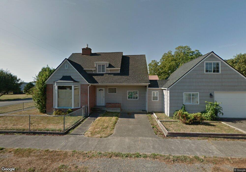
211 S 5th St Toledo, WA 98591
Estimated Value: $185,000 - $544,000
4
Beds
1
Bath
1,451
Sq Ft
$237/Sq Ft
Est. Value
About This Home
This home is located at 211 S 5th St, Toledo, WA 98591 and is currently estimated at $344,120, approximately $237 per square foot. 211 S 5th St is a home located in Lewis County with nearby schools including Toledo Elementary School, Toledo Middle School, and Toledo High School.
Ownership History
Date
Name
Owned For
Owner Type
Purchase Details
Closed on
Apr 3, 2009
Sold by
Us Bank National Association
Bought by
Woody Samuel H and Woody Birdenne A
Current Estimated Value
Purchase Details
Closed on
Jan 19, 2009
Sold by
Hibbs Melissa
Bought by
Us Bank National Association
Purchase Details
Closed on
Apr 29, 2005
Sold by
Hibbs Donald F
Bought by
Hibbs Melissa A
Home Financials for this Owner
Home Financials are based on the most recent Mortgage that was taken out on this home.
Original Mortgage
$119,600
Interest Rate
6.45%
Mortgage Type
Adjustable Rate Mortgage/ARM
Create a Home Valuation Report for This Property
The Home Valuation Report is an in-depth analysis detailing your home's value as well as a comparison with similar homes in the area
Home Values in the Area
Average Home Value in this Area
Purchase History
| Date | Buyer | Sale Price | Title Company |
|---|---|---|---|
| Woody Samuel H | $74,910 | Title Guaranty | |
| Us Bank National Association | $158,980 | Title Guaranty | |
| Hibbs Melissa A | -- | None Available | |
| Hibbs Melissa A | -- | None Available |
Source: Public Records
Mortgage History
| Date | Status | Borrower | Loan Amount |
|---|---|---|---|
| Previous Owner | Hibbs Melissa A | $119,600 |
Source: Public Records
Tax History Compared to Growth
Tax History
| Year | Tax Paid | Tax Assessment Tax Assessment Total Assessment is a certain percentage of the fair market value that is determined by local assessors to be the total taxable value of land and additions on the property. | Land | Improvement |
|---|---|---|---|---|
| 2024 | $1,418 | $222,500 | $56,200 | $166,300 |
| 2023 | $1,273 | $195,700 | $45,900 | $149,800 |
| 2022 | $1,628 | $194,800 | $36,100 | $158,700 |
| 2021 | $1,444 | $194,800 | $36,100 | $158,700 |
| 2020 | $1,394 | $159,700 | $31,500 | $128,200 |
| 2019 | $1,320 | $142,900 | $15,400 | $127,500 |
| 2018 | $1,301 | $135,300 | $13,500 | $121,800 |
| 2017 | $1,208 | $129,700 | $13,500 | $116,200 |
| 2016 | $1,157 | $124,900 | $12,100 | $112,800 |
| 2015 | $1,468 | $115,200 | $12,700 | $102,500 |
| 2013 | $1,468 | $151,900 | $33,300 | $118,600 |
Source: Public Records
Map
Nearby Homes
- 300 Maple St
- 500 Cedar St
- 0 Pine Tree Rd Unit NWM2322660
- 621 S 2nd St
- 0 State Route 505 Unit 23975666
- 112 Plomondon Rd
- 220 Plomondon Rd
- 243 12 Collins Rd
- 142 Drews Prairie Rd
- 243 Collins Rd
- 120 Lumsden Ln
- 1639 State Route 505
- 0 Rakoz Rd
- 237 Collins Rd
- 0 Eadon Rd Unit NWM2371783
- 0 Henriot Rd
- 5514 Jackson Hwy
- 387 Collins Rd
- 10 Tooley Rd
- 440 Knowles Rd