A
Seller's Agent in 2025
Ashley Cross
EPM Real Estate
(573) 421-0151
10 in this area
56 Total Sales
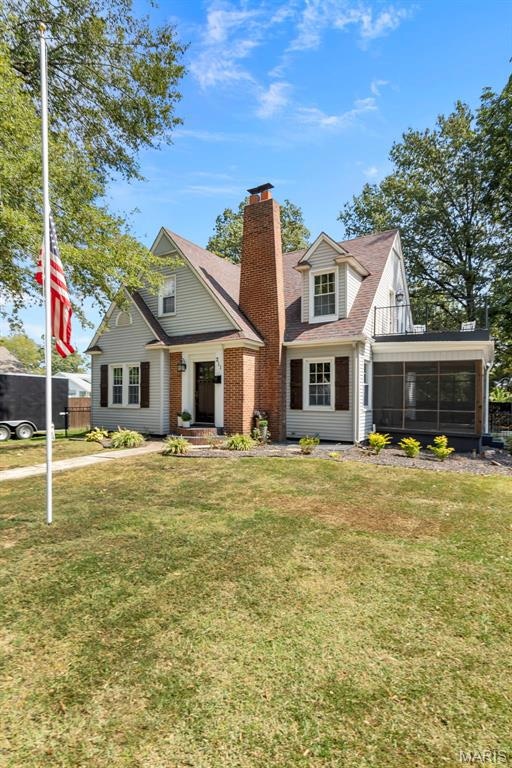


Downtown Dexter Showstopper!
This fully updated Victorian-style gem boasts 3 spacious bedrooms, 3 bathrooms, and 2,100 sq. ft. of living space. From the moment you step inside, the high-end finishes and custom details will take your breath away—think designer tile showers, gleaming surfaces, and modern touches throughout. The fenced yard offers the perfect outdoor retreat, while the detached one-car garage adds convenience. With its prime downtown location, this home blends timeless character with today’s luxuries. It’s a rare opportunity to own a true Dexter treasure this nice.
Last Agent to Sell the Property
EPM Real Estate License #2023028331 Listed on: 09/18/2025
| Date | Type | Sale Price | Title Company |
|---|---|---|---|
| Warranty Deed | $162,500 | Stoddard Cnty Title & Escrow | |
| Warranty Deed | $270,000 | Stoddard Cnty Title & Escrow | |
| Grant Deed | $225,000 | -- |
| Date | Status | Loan Amount | Loan Type |
|---|---|---|---|
| Open | $130,000 | Construction | |
| Previous Owner | $216,000 | Construction | |
| Closed | $180,000 | No Value Available |
| Date | Event | Price | List to Sale | Price per Sq Ft |
|---|---|---|---|---|
| 10/17/2025 10/17/25 | Sold | -- | -- | -- |
| 09/22/2025 09/22/25 | Pending | -- | -- | -- |
| 09/18/2025 09/18/25 | For Sale | $259,900 | -- | $124 / Sq Ft |
| Year | Tax Paid | Tax Assessment Tax Assessment Total Assessment is a certain percentage of the fair market value that is determined by local assessors to be the total taxable value of land and additions on the property. | Land | Improvement |
|---|---|---|---|---|
| 2025 | $901 | $20,729 | $0 | $0 |
| 2024 | $9 | $19,475 | $0 | $0 |
| 2023 | $900 | $19,475 | $0 | $0 |
| 2022 | $851 | $18,449 | $0 | $0 |
| 2021 | $851 | $18,449 | $0 | $0 |
| 2020 | $803 | $17,138 | $0 | $0 |
| 2019 | $802 | $17,309 | $0 | $0 |
| 2018 | $789 | $17,138 | $0 | $0 |
| 2016 | $734 | $16,454 | $0 | $0 |
| 2015 | -- | $15,865 | $0 | $0 |
| 2014 | -- | $15,751 | $0 | $0 |
| 2013 | -- | $0 | $0 | $0 |
A
Seller's Agent in 2025
Ashley Cross
EPM Real Estate
(573) 421-0151
10 in this area
56 Total Sales
I
Buyer's Agent in 2025
Isaac Stevens
Young Real Estate LLC
1 in this area
2 Total Sales
Source: MARIS MLS
MLS Number: MIS25063581
APN: 19-5.0-022-003-018-005.00000
Disclaimer: Certain information contained herein is derived from information provided by parties other than Homes.com. All information provided is deemed reliable, but is not guaranteed to be accurate and should be independently verified.
![]() Based on information submitted to the MLS GRID. All data is obtained from various sources and may not have been verified by broker or MLS GRID. Supplied Open House Information is subject to change without notice. All information should be independently reviewed and verified for accuracy. Properties may or may not be listed by the office/agent presenting the information. Some IDX listings have been excluded from this website.
Based on information submitted to the MLS GRID. All data is obtained from various sources and may not have been verified by broker or MLS GRID. Supplied Open House Information is subject to change without notice. All information should be independently reviewed and verified for accuracy. Properties may or may not be listed by the office/agent presenting the information. Some IDX listings have been excluded from this website.
Based on information submitted to the MLS GRID
Ask me questions while you tour the home.
