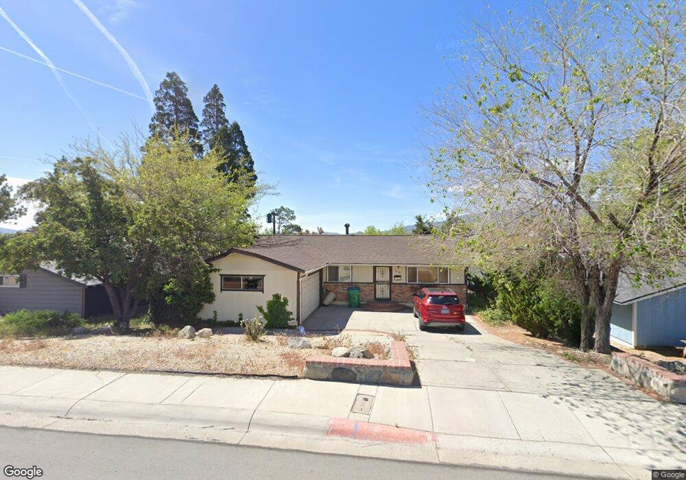
2110 W 7th St Reno, NV 89503
Kings Row NeighborhoodEstimated Value: $455,000 - $603,000
5
Beds
3
Baths
1,276
Sq Ft
$397/Sq Ft
Est. Value
About This Home
This home is located at 2110 W 7th St, Reno, NV 89503 and is currently estimated at $506,250, approximately $396 per square foot. 2110 W 7th St is a home located in Washoe County with nearby schools including Elmcrest Elementary School, Archie Clayton Pre-AP Academy, and Reno High School.
Ownership History
Date
Name
Owned For
Owner Type
Purchase Details
Closed on
Apr 2, 2009
Sold by
Mclean David M
Bought by
Mclean David M and David M Mclean Living Trust
Current Estimated Value
Purchase Details
Closed on
Dec 9, 1994
Sold by
Wait Richard P
Bought by
Mclean David M and Mclean Claudene G
Home Financials for this Owner
Home Financials are based on the most recent Mortgage that was taken out on this home.
Original Mortgage
$85,000
Interest Rate
9.1%
Create a Home Valuation Report for This Property
The Home Valuation Report is an in-depth analysis detailing your home's value as well as a comparison with similar homes in the area
Home Values in the Area
Average Home Value in this Area
Purchase History
| Date | Buyer | Sale Price | Title Company |
|---|---|---|---|
| Mclean David M | -- | None Available | |
| Mclean David M | $135,000 | Stewart Title |
Source: Public Records
Mortgage History
| Date | Status | Borrower | Loan Amount |
|---|---|---|---|
| Closed | Mclean David M | $85,000 |
Source: Public Records
Tax History
| Year | Tax Paid | Tax Assessment Tax Assessment Total Assessment is a certain percentage of the fair market value that is determined by local assessors to be the total taxable value of land and additions on the property. | Land | Improvement |
|---|---|---|---|---|
| 2026 | $824 | $62,726 | $34,242 | $28,483 |
| 2025 | $1,058 | $64,132 | $35,816 | $28,316 |
| 2024 | $1,058 | $61,315 | $33,737 | $27,579 |
| 2023 | $1,028 | $60,635 | $35,280 | $25,355 |
| 2022 | $998 | $49,027 | $28,350 | $20,677 |
| 2021 | $969 | $39,356 | $19,121 | $20,235 |
| 2020 | $939 | $37,933 | $17,987 | $19,946 |
| 2019 | $912 | $37,048 | $18,270 | $18,778 |
| 2018 | $886 | $30,930 | $13,010 | $17,920 |
| 2017 | $860 | $29,214 | $11,624 | $17,590 |
| 2016 | $839 | $27,617 | $10,206 | $17,411 |
| 2015 | $837 | $25,953 | $8,663 | $17,290 |
| 2014 | $813 | $24,125 | $7,718 | $16,407 |
| 2013 | -- | $21,452 | $5,513 | $15,939 |
Source: Public Records
Map
Nearby Homes
- 575 Northstar Dr
- 880 Ruby Ave
- 2000 Royal Dr
- 820 Wyoming Ave
- 2720 Judith Ln
- 2601 Powder Dr
- 1840 Windsor Way
- 745 Akard Dr
- 2091 W 4th St
- 1510 Majestic Dr Unit one
- 4232 Fawnridge Place
- 4128 Scenic Dr
- 1695 Severn Dr
- 1155 Beldon Way
- 2300 Dickerson Rd Unit 16
- 2801 Kings Row
- 1620 Harold Dr
- 1155 Wesley Dr
- 2562 River Hatchling Ln
- 2285 King Edward Dr