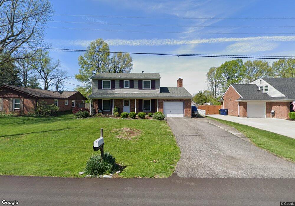
2114 Westridge Rd Louisville, KY 40242
North Central Jefferson County NeighborhoodEstimated Value: $359,000 - $388,000
4
Beds
3
Baths
2,410
Sq Ft
$155/Sq Ft
Est. Value
About This Home
This home is located at 2114 Westridge Rd, Louisville, KY 40242 and is currently estimated at $374,577, approximately $155 per square foot. 2114 Westridge Rd is a home located in Jefferson County with nearby schools including Wilder Elementary School, Zachary Taylor Elementary School, and Norton Elementary School.
Ownership History
Date
Name
Owned For
Owner Type
Purchase Details
Closed on
Sep 15, 2010
Sold by
Weichert Relocation Resources Inc
Bought by
Wiselogel Angie Lauer
Current Estimated Value
Home Financials for this Owner
Home Financials are based on the most recent Mortgage that was taken out on this home.
Original Mortgage
$185,994
Outstanding Balance
$122,381
Interest Rate
4.37%
Mortgage Type
FHA
Estimated Equity
$252,197
Create a Home Valuation Report for This Property
The Home Valuation Report is an in-depth analysis detailing your home's value as well as a comparison with similar homes in the area
Home Values in the Area
Average Home Value in this Area
Purchase History
| Date | Buyer | Sale Price | Title Company |
|---|---|---|---|
| Wiselogel Angie Lauer | $188,500 | Ky Title | |
| Weichert Relocation Resources Inc | $188,500 | Ky Title |
Source: Public Records
Mortgage History
| Date | Status | Borrower | Loan Amount |
|---|---|---|---|
| Open | Wiselogel Angie Lauer | $185,994 |
Source: Public Records
Tax History Compared to Growth
Tax History
| Year | Tax Paid | Tax Assessment Tax Assessment Total Assessment is a certain percentage of the fair market value that is determined by local assessors to be the total taxable value of land and additions on the property. | Land | Improvement |
|---|---|---|---|---|
| 2024 | $2,760 | $247,570 | $39,000 | $208,570 |
| 2023 | $2,842 | $247,570 | $39,000 | $208,570 |
| 2022 | $2,852 | $204,110 | $35,000 | $169,110 |
| 2021 | $2,541 | $204,110 | $35,000 | $169,110 |
| 2020 | $2,362 | $204,110 | $35,000 | $169,110 |
| 2019 | $2,314 | $204,110 | $35,000 | $169,110 |
| 2018 | $2,287 | $204,110 | $35,000 | $169,110 |
| 2017 | $2,142 | $204,110 | $35,000 | $169,110 |
| 2013 | $1,885 | $188,500 | $37,000 | $151,500 |
Source: Public Records
Map
Nearby Homes
- 2114 Ashcraft Ln
- 8822 Staghorn Dr
- 8612 Wintergreen Ct Unit 104
- 9016 Fawn Ct Unit 130
- 9100 Trentham Ct
- 8622 Locust Ct
- 8612 Locust Ct Unit 36
- 1851 Washington Blvd
- 1853 Washington Blvd
- 2103 Redleaf Dr
- 1855 Washington Blvd
- Mitchell Plan at Lyndon Green
- Hampton Plan at Lyndon Green
- Aspire Plan at Lyndon Green
- 1857 Washington Blvd
- 1852 Washington Blvd
- 1861 Washington Blvd
- 1867 Washington Blvd
- 1850 Washington Blvd
- 2001 Lyndon Green Cir
- 2112 Westridge Rd
- 8725 Deer Point Ct
- 2110 Westridge Rd
- 8918 Cardiff Rd
- 2115 Westridge Rd
- 9001 Westridge Ct
- 8721 Deer Point Ct Unit 57
- 8721 Deer Point Ct Unit 1
- 2117 Westridge Rd
- 8722 Deer Point Ct
- 2108 Westridge Rd
- 8720 Deer Point Ct
- 9000 Cardiff Rd
- 8719 Deer Point Ct
- 8718 Deer Point Ct Unit 63
- 8811 Doe Run Ct
- 9000 Westridge Ct
- 2106 Westridge Rd
- 9003 Westridge Ct
- 8812 Doe Run Ct Unit 82