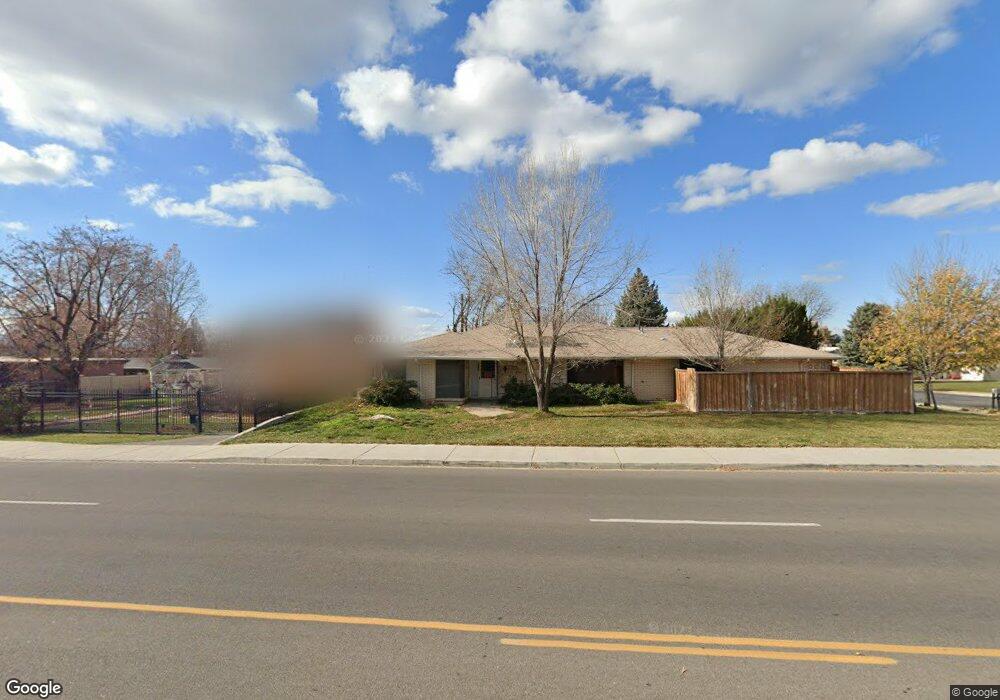
2115 N 150 E Provo, UT 84604
Rock Canyon NeighborhoodEstimated Value: $673,000 - $784,000
7
Beds
5
Baths
3,769
Sq Ft
$193/Sq Ft
Est. Value
About This Home
This home is located at 2115 N 150 E, Provo, UT 84604 and is currently estimated at $726,515, approximately $192 per square foot. 2115 N 150 E is a home located in Utah County with nearby schools including Rock Canyon Elementary School, Centennial Middle School, and Timpview High School.
Ownership History
Date
Name
Owned For
Owner Type
Purchase Details
Closed on
Jul 27, 2012
Sold by
Hovey Verl and Hovey Marianne D
Bought by
Yang Chongming
Current Estimated Value
Home Financials for this Owner
Home Financials are based on the most recent Mortgage that was taken out on this home.
Original Mortgage
$271,000
Outstanding Balance
$188,441
Interest Rate
3.75%
Mortgage Type
FHA
Estimated Equity
$538,074
Purchase Details
Closed on
Feb 15, 2012
Sold by
Andrus Mark M and Andrus Deborah M
Bought by
Hovey Verl and Hovey Marianne D
Home Financials for this Owner
Home Financials are based on the most recent Mortgage that was taken out on this home.
Original Mortgage
$165,000
Interest Rate
3.86%
Mortgage Type
Commercial
Purchase Details
Closed on
Jan 10, 2007
Sold by
Oak Ridge Properties Llc
Bought by
Andrus Mark M and Andrus Deborah M
Home Financials for this Owner
Home Financials are based on the most recent Mortgage that was taken out on this home.
Original Mortgage
$45,000
Interest Rate
6.09%
Mortgage Type
Credit Line Revolving
Purchase Details
Closed on
Sep 7, 2006
Sold by
Andrus Mark M and Andrus Deborah M
Bought by
Oak Ridge Properties Llc
Home Financials for this Owner
Home Financials are based on the most recent Mortgage that was taken out on this home.
Original Mortgage
$228,750
Interest Rate
3.25%
Mortgage Type
Commercial
Purchase Details
Closed on
Aug 30, 2006
Sold by
Oak Ridge Properties Llc
Bought by
Andrus Mark M and Andrus Deborah M
Home Financials for this Owner
Home Financials are based on the most recent Mortgage that was taken out on this home.
Original Mortgage
$228,750
Interest Rate
3.25%
Mortgage Type
Commercial
Purchase Details
Closed on
May 5, 2005
Sold by
Westphal Zak and Westphal Carol
Bought by
Oak Ridge Properties Llc
Home Financials for this Owner
Home Financials are based on the most recent Mortgage that was taken out on this home.
Original Mortgage
$184,000
Interest Rate
5.99%
Mortgage Type
Seller Take Back
Purchase Details
Closed on
Jan 8, 2002
Sold by
M M Capital Corp
Bought by
Down David W and Down Shirlene A
Purchase Details
Closed on
Oct 4, 2000
Sold by
Woods Mary Margaret
Bought by
M M Capital Corp
Create a Home Valuation Report for This Property
The Home Valuation Report is an in-depth analysis detailing your home's value as well as a comparison with similar homes in the area
Home Values in the Area
Average Home Value in this Area
Purchase History
| Date | Buyer | Sale Price | Title Company |
|---|---|---|---|
| Yang Chongming | -- | Eagle Pointe Title Insurance | |
| Hovey Verl | -- | Title West Spanish Fork | |
| Andrus Mark M | -- | Title West Title Company | |
| Oak Ridge Properties Llc | -- | Title West Title Company | |
| Andrus Mark M | -- | Title West Title Company | |
| Oak Ridge Properties Llc | -- | Empire Land Title Company | |
| Down David W | -- | Signature Title | |
| M M Capital Corp | -- | -- |
Source: Public Records
Mortgage History
| Date | Status | Borrower | Loan Amount |
|---|---|---|---|
| Open | Yang Chongming | $271,000 | |
| Previous Owner | Hovey Verl | $165,000 | |
| Previous Owner | Andrus Mark M | $45,000 | |
| Previous Owner | Andrus Mark M | $228,750 | |
| Previous Owner | Oak Ridge Properties Llc | $184,000 |
Source: Public Records
Tax History
| Year | Tax Paid | Tax Assessment Tax Assessment Total Assessment is a certain percentage of the fair market value that is determined by local assessors to be the total taxable value of land and additions on the property. | Land | Improvement |
|---|---|---|---|---|
| 2025 | $3,639 | $350,295 | -- | -- |
| 2024 | $3,639 | $358,215 | $0 | $0 |
| 2023 | $3,655 | $354,695 | $0 | $0 |
| 2022 | $3,452 | $337,810 | $0 | $0 |
| 2021 | $2,879 | $491,300 | $171,900 | $319,400 |
| 2020 | $2,742 | $438,700 | $153,500 | $285,200 |
| 2019 | $2,453 | $408,100 | $133,300 | $274,800 |
| 2018 | $2,282 | $433,500 | $205,800 | $227,700 |
| 2017 | $2,211 | $204,985 | $0 | $0 |
| 2016 | $2,023 | $174,790 | $0 | $0 |
| 2015 | $1,819 | $158,895 | $0 | $0 |
| 2014 | $1,606 | $146,245 | $0 | $0 |
Source: Public Records
Map
Nearby Homes
- 186 E 2100 N
- 182 E 2090 N
- 240 E 2230 N Unit 7
- 1960 N Canyon Rd
- 360 Sumac Ln
- 223 W 2230 N Unit 14
- 241 W 2230 N Unit 16
- 1801 N 650 E
- 2735 N Country Club Dr
- 264 W 1625 N
- 2774 N 370 E
- 1470 N 380 W
- 788 E 2680 N
- 431 W 2310 N
- 2939 N Marrcrest Dr W
- 2999 N Marrcrest West Dr
- 3013 N 100 W
- 3025 N 250 E
- 3057 N 100 W
- 1108 E 2620 N
- 2115 N Canyon Rd
- 2109 N Canyon Rd
- 2102 N 80 E
- 101 E 2120 N
- 2085 N Canyon Rd
- 163 E 2100 N
- 2112 N Canyon Rd
- 2114 N Canyon Rd
- 165 E 2100 N
- 2110 N Canyon Rd
- 161 E 2100 N
- 161 E 2100 N Unit 3
- 159 E 2100 N Unit 2
- 159 E 2100 N Unit 4
- 159 E 2100 N
- 2048 N 80 E
- 81 E 2120 N
- 2122 N Canyon Rd
- 2105 N 80 E
- 71 E 2050 N
Your Personal Tour Guide
Ask me questions while you tour the home.