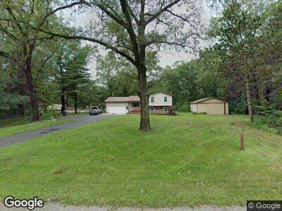
2117 S Maple Island Rd Muskegon, MI 49442
Estimated Value: $231,000 - $364,000
3
Beds
2
Baths
1,232
Sq Ft
$220/Sq Ft
Est. Value
About This Home
This home is located at 2117 S Maple Island Rd, Muskegon, MI 49442 and is currently estimated at $270,734, approximately $219 per square foot. 2117 S Maple Island Rd is a home located in Muskegon County with nearby schools including Oakridge Lower Elementary School, Oakridge Upper Elementary School, and Oakridge Middle School.
Ownership History
Date
Name
Owned For
Owner Type
Purchase Details
Closed on
Aug 5, 2011
Sold by
Tromp George J and Tromp Thelma
Bought by
Davis Michael P and Davis Diana R
Current Estimated Value
Home Financials for this Owner
Home Financials are based on the most recent Mortgage that was taken out on this home.
Original Mortgage
$103,020
Outstanding Balance
$72,359
Interest Rate
4.5%
Mortgage Type
FHA
Estimated Equity
$198,375
Purchase Details
Closed on
Jan 31, 2007
Sold by
Tromp Tim G and Tromp Jennifer L
Bought by
Tromp George J and Tromp Thelma
Home Financials for this Owner
Home Financials are based on the most recent Mortgage that was taken out on this home.
Original Mortgage
$100,000
Interest Rate
6.22%
Mortgage Type
New Conventional
Create a Home Valuation Report for This Property
The Home Valuation Report is an in-depth analysis detailing your home's value as well as a comparison with similar homes in the area
Home Values in the Area
Average Home Value in this Area
Purchase History
| Date | Buyer | Sale Price | Title Company |
|---|---|---|---|
| Davis Michael P | $109,900 | Chicago Title | |
| Tromp George J | -- | Safe Title Inc |
Source: Public Records
Mortgage History
| Date | Status | Borrower | Loan Amount |
|---|---|---|---|
| Open | Davis Michael P | $103,020 | |
| Previous Owner | Tromp George J | $100,000 | |
| Previous Owner | Tromp Tim G | $96,000 |
Source: Public Records
Tax History Compared to Growth
Tax History
| Year | Tax Paid | Tax Assessment Tax Assessment Total Assessment is a certain percentage of the fair market value that is determined by local assessors to be the total taxable value of land and additions on the property. | Land | Improvement |
|---|---|---|---|---|
| 2024 | $634 | $100,600 | $0 | $0 |
| 2023 | $606 | $86,400 | $0 | $0 |
| 2022 | $1,768 | $74,100 | $0 | $0 |
| 2021 | $1,722 | $68,000 | $0 | $0 |
| 2020 | $1,706 | $65,400 | $0 | $0 |
| 2019 | $1,619 | $60,000 | $0 | $0 |
| 2018 | $1,581 | $53,300 | $0 | $0 |
| 2017 | $1,548 | $52,600 | $0 | $0 |
| 2016 | $517 | $48,900 | $0 | $0 |
| 2015 | -- | $51,100 | $0 | $0 |
| 2014 | -- | $44,500 | $0 | $0 |
| 2013 | -- | $44,000 | $0 | $0 |
Source: Public Records
Map
Nearby Homes
- 7258 Sue Marie Ln
- 6865 Evanston Ave
- 1826 Barnes Rd
- 6672 Minard Dr
- 6991 E Apple Ave
- 6975 E Apple Ave
- 6772 E Apple Ave
- 3344 S Hilton Park Rd
- 3511 Barnes Rd
- 0 Hilltop Dr Unit 50171431
- 0 Silver Creek Rd Unit 1924407
- 0 W Potter Rd Unit 50137588
- 1 Balian Dr
- 555 S Maple Island Rd
- 1286 Holiday St
- 655 S Hilton Park Rd
- 653 Chatterson Rd
- 412 Sabine Dr Unit 11
- 241 Jayden Dr
- 6001 Savannah Way Unit 36
- 2117 S Maple Island Rd
- 2133 S Maple Island Rd
- 2118 S Maple Island Rd
- 2102 S Maple Island Rd
- 2055 S Maple Island Rd
- 2072 S Maple Island Rd
- 2150 S Maple Island Rd
- 7158 Evanston Ave
- 2081 S Maple Island Rd
- 2173 S Maple Island Rd
- 2054 S Maple Island Rd
- 7152 Evanston Ave
- 2196 S Maple Island Rd
- 2038 S Maple Island Rd
- 7134 Evanston Ave
- 7240 Evanston Ave
- 6993 Evanston Ave
- 7084 Evanston Ave
- 7256 Evanston Ave
- 7260 Evanston Ave