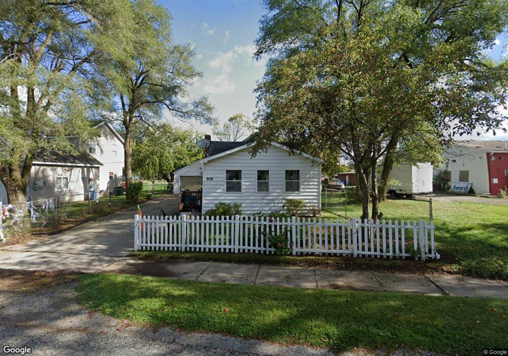
2118 Newark Ave Lansing, MI 48911
Southern Lansing NeighborhoodEstimated Value: $97,865 - $126,000
--
Bed
--
Bath
785
Sq Ft
$143/Sq Ft
Est. Value
About This Home
This home is located at 2118 Newark Ave, Lansing, MI 48911 and is currently estimated at $112,216, approximately $142 per square foot. 2118 Newark Ave is a home located in Ingham County with nearby schools including Reo Elementary School, Attwood School, and Everett High School.
Ownership History
Date
Name
Owned For
Owner Type
Purchase Details
Closed on
Nov 16, 2009
Sold by
Rendon Reynaldo and Rendon Maria D
Bought by
Rendon Reynaldo B and Rendon Maria L
Current Estimated Value
Purchase Details
Closed on
Apr 16, 1969
Sold by
Remez Walter H and Remez Aune M
Bought by
Rendon Reynaldo and Rendon Maria D
Create a Home Valuation Report for This Property
The Home Valuation Report is an in-depth analysis detailing your home's value as well as a comparison with similar homes in the area
Home Values in the Area
Average Home Value in this Area
Purchase History
| Date | Buyer | Sale Price | Title Company |
|---|---|---|---|
| Rendon Reynaldo B | -- | None Available | |
| Rendon Reynaldo | $6,900 | -- | |
| Rendon Reynaldo | $6,900 | Burton Abstract & Title Co |
Source: Public Records
Tax History Compared to Growth
Tax History
| Year | Tax Paid | Tax Assessment Tax Assessment Total Assessment is a certain percentage of the fair market value that is determined by local assessors to be the total taxable value of land and additions on the property. | Land | Improvement |
|---|---|---|---|---|
| 2025 | $1,404 | $49,000 | $6,000 | $43,000 |
| 2024 | $11 | $39,200 | $6,000 | $33,200 |
| 2023 | $1,320 | $33,500 | $6,000 | $27,500 |
| 2022 | $1,195 | $28,700 | $4,200 | $24,500 |
| 2021 | $1,170 | $25,600 | $4,200 | $21,400 |
| 2020 | $1,162 | $23,900 | $4,200 | $19,700 |
| 2019 | $1,111 | $21,200 | $4,200 | $17,000 |
| 2018 | $1,045 | $17,800 | $4,200 | $13,600 |
| 2017 | $999 | $17,800 | $4,200 | $13,600 |
| 2016 | $956 | $17,100 | $4,200 | $12,900 |
| 2015 | $956 | $16,300 | $8,379 | $7,921 |
| 2014 | $956 | $16,000 | $13,033 | $2,967 |
Source: Public Records
Map
Nearby Homes
- 6030 Piper Ave
- 5838 S Martin Luther King Junior Blvd
- 6037 Hughes Rd
- 2045 Moffitt St
- 5750 Ashley Dr
- 1119 W Miller Rd
- 0 Midwood St
- 1020 R G Curtiss Ave
- 2416 Midwood St
- 3400 Independence Ln
- 1014 W Northrup St
- 5906 Monticello Dr
- 4828 Ingham St
- 4916 Tressa Dr
- 6270 S Washington Ave
- 4809 Ballard Rd
- 4628 Pleasant Grove Rd
- 2626 Little Hickory Dr
- 0 W Jolly Rd
- 4620 Christiansen Rd
- 2122 Newark Ave
- 6030 S Martin Luther King jr Blvd
- 6030 S Martin Luther King Junior Blvd
- 2117 Newark Ave
- 6026 S Martin Luther King jr Blvd
- 2126 Newark Ave
- 2130 Newark Ave
- 2133 Newark Ave
- 6016 S Mlk Blvd
- 2136 Newark Ave
- 5921 Piper Ave
- 2035 Webster St
- 2017 Webster St
- 5915 Piper Ave
- 6012 S Mlk Blvd
- 2023 Webster St
- 2119 Webster St
- 6000 Piper Ave
- 6008 Piper Ave