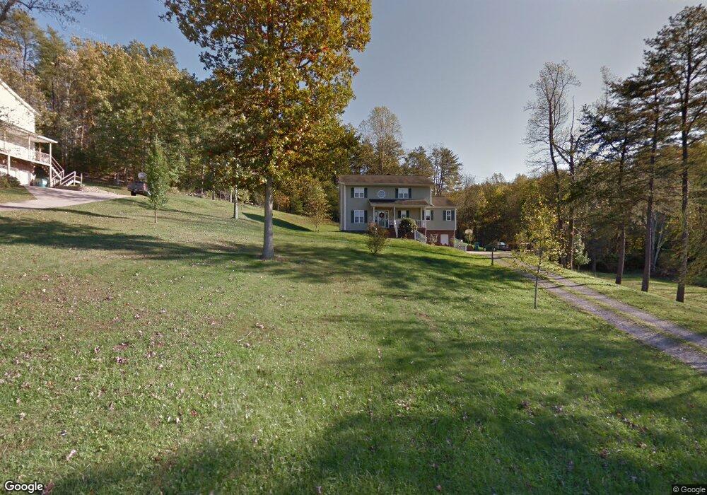
212 Cedar Dr Scott Depot, WV 25560
Estimated Value: $295,000 - $401,000
4
Beds
4
Baths
2,250
Sq Ft
$152/Sq Ft
Est. Value
About This Home
This home is located at 212 Cedar Dr, Scott Depot, WV 25560 and is currently estimated at $343,032, approximately $152 per square foot. 212 Cedar Dr is a home located in Putnam County with nearby schools including Teays Valley Christian School and Calvary Baptist Academy.
Ownership History
Date
Name
Owned For
Owner Type
Purchase Details
Closed on
May 1, 2008
Sold by
Primacy Closing Corporation
Bought by
Unroe Billy A and Unroe Amber N
Current Estimated Value
Home Financials for this Owner
Home Financials are based on the most recent Mortgage that was taken out on this home.
Original Mortgage
$147,120
Interest Rate
6.17%
Mortgage Type
Purchase Money Mortgage
Create a Home Valuation Report for This Property
The Home Valuation Report is an in-depth analysis detailing your home's value as well as a comparison with similar homes in the area
Home Values in the Area
Average Home Value in this Area
Purchase History
| Date | Buyer | Sale Price | Title Company |
|---|---|---|---|
| Unroe Billy A | $183,900 | -- | |
| Primacy Closing Corporation | $181,900 | -- |
Source: Public Records
Mortgage History
| Date | Status | Borrower | Loan Amount |
|---|---|---|---|
| Previous Owner | Primacy Closing Corporation | $147,120 |
Source: Public Records
Tax History Compared to Growth
Tax History
| Year | Tax Paid | Tax Assessment Tax Assessment Total Assessment is a certain percentage of the fair market value that is determined by local assessors to be the total taxable value of land and additions on the property. | Land | Improvement |
|---|---|---|---|---|
| 2025 | $1,853 | $146,580 | $34,020 | $112,560 |
| 2024 | $1,853 | $136,620 | $34,020 | $102,600 |
| 2023 | $1,540 | $123,420 | $34,020 | $89,400 |
| 2022 | $1,455 | $120,720 | $34,020 | $86,700 |
| 2021 | $1,314 | $108,540 | $29,640 | $78,900 |
| 2020 | $1,443 | $119,340 | $22,200 | $97,140 |
| 2019 | $1,396 | $113,700 | $22,200 | $91,500 |
| 2018 | $1,389 | $112,860 | $22,200 | $90,660 |
| 2017 | $1,377 | $110,940 | $21,660 | $89,280 |
| 2016 | $1,393 | $111,660 | $25,380 | $86,280 |
| 2015 | $1,496 | $118,860 | $31,020 | $87,840 |
| 2014 | $1,223 | $97,320 | $15,960 | $81,360 |
Source: Public Records
Map
Nearby Homes
- 0 Tbd Hedrick Rd
- 149 Beechwood Estates
- 7732 Teays Valley Rd
- 5431 Teays Valley Rd
- TBD Hedrick Rd
- 107 Woodstone Dr
- 115 Rolling Meadows Dr
- 146 Tyler Way
- 107 Countryside Rd
- 200 Bent Tree Estates
- 116 Knights Ct
- 111 Heritage Place
- 127 Litton Heights
- 106 Heather Ct
- 413 Lyman Ln
- 75 Poinsettia Dr
- 0 Hedrick Rd Unit WVPU2000008
- 104 Lynn Knolls
- Lot 12 Crooked Creek Rd
- 2671 Scott Depot Rd