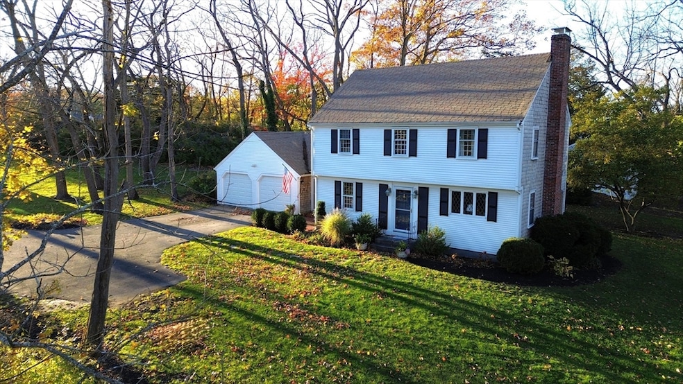
212 S Main St Cohasset, MA 02025
Estimated payment $8,667/month
Highlights
- Marina
- Golf Course Community
- 1.54 Acre Lot
- Deer Hill School Rated A-
- Barn or Stable
- Colonial Architecture
About This Home
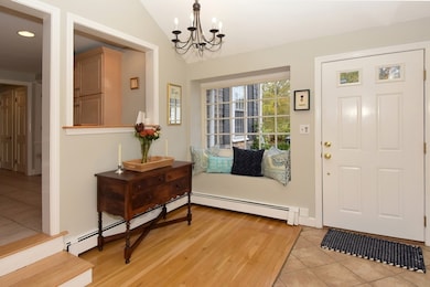
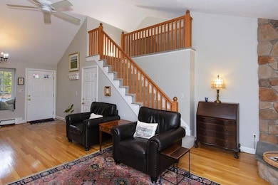
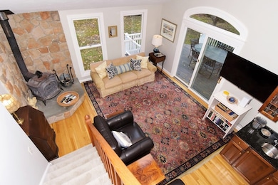
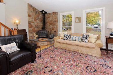
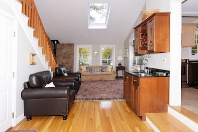
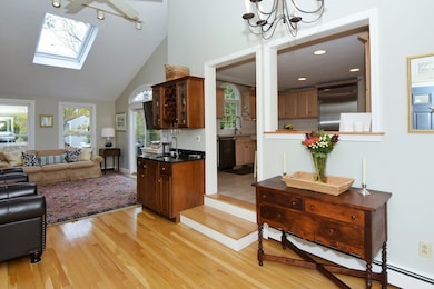
Welcome to this exquisite Cohasset Colonial that is nestled on a serene 1.54 acres of private coastal splendor in the heart of Cohasset. This 2,462 sqft masterpiece radiates timeless New England elegance, featuring 4 sun-drenched bedrooms, 2 lavish baths. Gleaming hardwood floors sweep through an open, airy layout crafted for effortless entertaining or cherished family living. The gourmet kitchen with stainless steel appliances sports abundant light & connects to the Family Room with soaring vaulted ceilings & a wood burning stove perfect for those cold nights. The renovated upstairs bath is a tranquil sanctuary with a spa-caliber fit & finish. Don’t miss the expansive maintenance free deck, large finished basement & 2 car garage. Mature trees frame expansive grounds—perfect with lush gardens & play spaces. A short distance to Cohasset Village, beaches, Wompatuck Park trails, yacht club, the vibrant harbor life & quick 3A access. Claim this rare Cohasset legacy of luxury & serenity!
Home Details
Home Type
- Single Family
Est. Annual Taxes
- $12,132
Year Built
- Built in 1956
Lot Details
- 1.54 Acre Lot
- Stone Wall
- Gentle Sloping Lot
- Wooded Lot
- Property is zoned RB
Parking
- 2 Car Attached Garage
- Driveway
- Open Parking
- Off-Street Parking
Home Design
- Colonial Architecture
- Frame Construction
- Shingle Roof
- Concrete Perimeter Foundation
Interior Spaces
- 2,462 Sq Ft Home
- Vaulted Ceiling
- 1 Fireplace
- Great Room
Kitchen
- Range
- Microwave
- Freezer
- Dishwasher
Flooring
- Wood
- Tile
Bedrooms and Bathrooms
- 4 Bedrooms
- Primary bedroom located on second floor
- 2 Full Bathrooms
Laundry
- Dryer
- Washer
Finished Basement
- Basement Fills Entire Space Under The House
- Laundry in Basement
Outdoor Features
- Bulkhead
- Deck
Location
- Property is near public transit
- Property is near schools
Horse Facilities and Amenities
- Barn or Stable
Utilities
- Window Unit Cooling System
- Heating System Uses Oil
- Baseboard Heating
- 200+ Amp Service
- Electric Water Heater
- Private Sewer
Listing and Financial Details
- Assessor Parcel Number M:F6 B:33 L:026,62923
Community Details
Overview
- No Home Owners Association
- Near Conservation Area
Amenities
- Shops
Recreation
- Marina
- Golf Course Community
- Tennis Courts
- Community Pool
- Park
- Jogging Path
- Bike Trail
Map
Home Values in the Area
Average Home Value in this Area
Tax History
| Year | Tax Paid | Tax Assessment Tax Assessment Total Assessment is a certain percentage of the fair market value that is determined by local assessors to be the total taxable value of land and additions on the property. | Land | Improvement |
|---|---|---|---|---|
| 2025 | $12,132 | $1,047,700 | $712,600 | $335,100 |
| 2024 | $10,823 | $889,300 | $569,900 | $319,400 |
| 2023 | $10,267 | $870,100 | $553,300 | $316,800 |
| 2022 | $9,239 | $735,600 | $448,000 | $287,600 |
| 2021 | $8,795 | $674,500 | $406,300 | $268,200 |
| 2020 | $8,748 | $674,500 | $406,300 | $268,200 |
| 2019 | $8,701 | $674,500 | $406,300 | $268,200 |
| 2018 | $8,627 | $674,500 | $406,300 | $268,200 |
| 2017 | $8,014 | $613,600 | $369,400 | $244,200 |
| 2016 | $7,903 | $613,600 | $369,400 | $244,200 |
| 2015 | $7,773 | $611,600 | $369,400 | $242,200 |
| 2014 | $7,669 | $611,600 | $369,400 | $242,200 |
Property History
| Date | Event | Price | List to Sale | Price per Sq Ft |
|---|---|---|---|---|
| 11/04/2025 11/04/25 | For Sale | $1,449,900 | -- | $589 / Sq Ft |
Purchase History
| Date | Type | Sale Price | Title Company |
|---|---|---|---|
| Quit Claim Deed | -- | None Available | |
| Deed | $245,000 | -- |
Mortgage History
| Date | Status | Loan Amount | Loan Type |
|---|---|---|---|
| Previous Owner | $227,000 | No Value Available | |
| Previous Owner | $48,500 | No Value Available | |
| Previous Owner | $10,400 | No Value Available | |
| Previous Owner | $175,000 | Purchase Money Mortgage |
Source: MLS Property Information Network (MLS PIN)
MLS Number: 73451300
APN: COHA-000006F-000033-000026
Disclaimer: Certain information contained herein is derived from information provided by parties other than Homes.com. All information provided is deemed reliable, but is not guaranteed to be accurate and should be independently verified.
![]() The property listing data and information, or the Images, set forth herein were provided to MLS Property Information Network, Inc. from third party sources, including sellers, lessors and public records, and were compiled by MLS Property Information Network, Inc. The property listing data and information, and the Images, are for the personal, non-commercial use of consumers having a good faith interest in purchasing or leasing listed properties of the type displayed to them and may not be used for any purpose other than to identify prospective properties which such consumers may have a good faith interest in purchasing or leasing. MLS Property Information Network, Inc. and its subscribers disclaim any and all representations and warranties as to the accuracy of the property listing data and information, or as to the accuracy of any of the Images, set forth herein.
The property listing data and information, or the Images, set forth herein were provided to MLS Property Information Network, Inc. from third party sources, including sellers, lessors and public records, and were compiled by MLS Property Information Network, Inc. The property listing data and information, and the Images, are for the personal, non-commercial use of consumers having a good faith interest in purchasing or leasing listed properties of the type displayed to them and may not be used for any purpose other than to identify prospective properties which such consumers may have a good faith interest in purchasing or leasing. MLS Property Information Network, Inc. and its subscribers disclaim any and all representations and warranties as to the accuracy of the property listing data and information, or as to the accuracy of any of the Images, set forth herein.
- 98 Black Horse Ln
- 68 Black Horse Ln
- 70 Black Horse Ln
- 40 Pond St
- 87 Elm St Unit 215
- 124 Elm St Unit 202
- 124 Elm St Unit 308
- 309 S Main St
- 4 Margin St Unit A
- 128 Elm St Unit 211
- 100 Pond St Unit 10
- 26 Ash St
- 73 Pond St
- 21-23 Elm Ct
- 15 Cushing Rd
- 104 Howard Gleason Rd
- 46 Pond St
- 100 Howard Gleason Rd
- 392 S Main St
- 89 Ripley Rd
- 31 S Main St Unit 31
- 1 Pleasant St Unit 206
- 1 Pleasant St Unit 202
- 1 Pleasant St Unit 306
- 1 Pleasant St Unit 301
- 1 Pleasant St Unit 201
- 1 Pleasant St Unit 204
- 1 Pleasant St Unit 205
- 1 Pleasant St Unit 307
- 1 Pleasant St Unit 302
- 1 Pleasant St Unit 305
- 17 Atlantic Ave Unit Main House
- 11 Beach St
- 430 S Main St Unit 5
- 67 Border St
- 92 Atlantic Ave
- 205-209 Sohier St
- 19 Hobart Ln
- 100 Avalon Dr
- 334 N Main St
